Difference between revisions of "2015-12-29 52 1"
From Geohashing
imported>Sourcerer m (→Achievements) |
m |
||
| (4 intermediate revisions by 2 users not shown) | |||
| Line 9: | Line 9: | ||
== Location == | == Location == | ||
| − | In a field behind the church of St. Mary the Virgin and St. Botolph, south of Aylsham, Norfolk, UK. | + | 1) In a field behind the church of St. Mary the Virgin and St. Botolph, south of Aylsham, Norfolk, UK. |
== Participants == | == Participants == | ||
| Line 19: | Line 19: | ||
Expedition one of three spanning midnight - [[2015-12-29 52 1]] - [[2015-12-29 52 0]] - [[2015-12-30 52 0]] - ETA 21:15. | Expedition one of three spanning midnight - [[2015-12-29 52 1]] - [[2015-12-29 52 0]] - [[2015-12-30 52 0]] - ETA 21:15. | ||
| − | == Expedition == | + | == Expedition - Fail == |
| + | The field behind the Rectory and Glebe Farm was well fenced against both small and large animals, including humans. The track log shows six fence tests. In every case the fence was in good order and could not be crossed without doing damage. My "no damage, no disturbance" rules prevented further progress. My closest approach was 90 metres. | ||
== Photos == | == Photos == | ||
<gallery> | <gallery> | ||
| − | |||
Image:2015-12-29_52_1_Sourcerer_1451423896191.jpg | Fail. [http://www.openstreetmap.org/?lat=52.75706649&lon=1.25945270&zoom=16&layers=B000FTF @52.7571,1.2595] | Image:2015-12-29_52_1_Sourcerer_1451423896191.jpg | Fail. [http://www.openstreetmap.org/?lat=52.75706649&lon=1.25945270&zoom=16&layers=B000FTF @52.7571,1.2595] | ||
| + | Image:2015-12-29_52_1_Sourcerer.jpg | Google Earth Track | ||
</gallery> | </gallery> | ||
| Line 41: | Line 42: | ||
[[Category:Expeditions with photos]] | [[Category:Expeditions with photos]] | ||
[[Category:Coordinates not reached]] | [[Category:Coordinates not reached]] | ||
| + | [[Category:Not reached - No public access]] | ||
| + | {{location|GB|ENG|NFK}} | ||
Latest revision as of 13:40, 27 March 2022
| Tue 29 Dec 2015 in Norwich, UK: 52.7548441, 1.2626942 geohashing.info google osm bing/os kml crox |
Location
1) In a field behind the church of St. Mary the Virgin and St. Botolph, south of Aylsham, Norfolk, UK.
Participants
Plans
Expedition one of three spanning midnight - 2015-12-29 52 1 - 2015-12-29 52 0 - 2015-12-30 52 0 - ETA 21:15.
Expedition - Fail
The field behind the Rectory and Glebe Farm was well fenced against both small and large animals, including humans. The track log shows six fence tests. In every case the fence was in good order and could not be crossed without doing damage. My "no damage, no disturbance" rules prevented further progress. My closest approach was 90 metres.
Photos
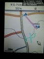
Fail. @52.7571,1.2595
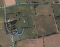
Google Earth Track


Achievements
Expeditions and Plans
| 2015-12-29 | ||
|---|---|---|
| Seattle, Washington | Benjamin Kaiser | In the trees/bushes (lots of ferns) behind a house in a seemingly quite wea... |
| Nürnberg, Germany | Breti | Huzza, my first Geohash Breti -- Breti (talk) @49.7548,11.2627 15:10, 29 ... |
| Bonn, Germany | Burgman | A meadow between Geistingen and Rott, near Hennef. |
| Cambridge, United Kingdom | Sourcerer | 2) In a field between the rivers Nene and Great Ouse, west of Kings Lynn, N... |
| Norwich, United Kingdom | Sourcerer | 1) In a field behind the church of St. Mary the Virgin and St. Botolph, sou... |
Sourcerer's Expedition Links
2015-12-28 52 1 - 2015-12-29 52 1 - 2015-12-29 52 0 - KML file download of Sourcerer's expeditions for use with Google Earth.