Difference between revisions of "2016-01-03 52 4"
imported>FelixTheCat |
imported>FippeBot m (Location) |
||
| Line 42: | Line 42: | ||
[[Category:Expeditions with photos]] | [[Category:Expeditions with photos]] | ||
[[Category:Coordinates reached]] | [[Category:Coordinates reached]] | ||
| + | {{location|NL|UT}} | ||
Latest revision as of 06:23, 15 August 2019
| Sun 3 Jan 2016 in 52,4: 52.0336429, 4.8717493 geohashing.info google osm bing/os kml crox |
Location
On the edge of the city of Oudewater, Utrecht province.
Participants
Plans
Today's hash seemed to be accessible, and required just a small(ish) detour from my trip to a New Year's event near Amsterdam.
Expedition
I got up early and set my car's GPS to today's coordinates. Officially Oudewater is a city, but by today's standards it's a rural village. The hash seemed to be located a little off the road at the northwestern edge of the "city". I parked my car in front of a building nearby and walked towards the hash. It seemed like I had to cross a ditch to get there, but luckily there was a crossing nearby. The area actually turned out to be a park, although with very tall grass. The ground was also very wet and muddy. As I approached the hash, a startled hare jumped out of the grass and ran away. Finally, I reached the hash (next to a small tree), took a few pictures, went back to the car and on to my event.
Photos
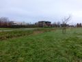
View towards a business park.
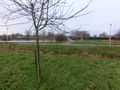
View towards a residential area (including skate ramp). Also, the hashtree.
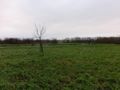
Outside the city are just fields.
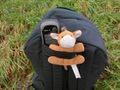
Lloyd posing at the hash.
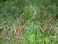
Lots of little apples on the ground. I'm no botanist, but I think this means that the hashtree is of the genus Malus.
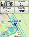
GPS proof.


Achievements
