Difference between revisions of "2016-01-07 52 1"
imported>Sourcerer m (→Location) |
m |
||
| (5 intermediate revisions by 2 users not shown) | |||
| Line 21: | Line 21: | ||
This might be close enough to the road for success, I might get rather wet or I could chicken out. | This might be close enough to the road for success, I might get rather wet or I could chicken out. | ||
| − | == Expedition == | + | == Expedition - Fail == |
| + | *Arrived. -- [[User:Sourcerer|Sourcerer]] ([[User talk:Sourcerer|talk]]) [http://www.openstreetmap.org/?lat=52.67012000&lon=1.50453150&zoom=16&layers=B000FTF @52.6701,1.5045] 13:33, 7 January 2016 (GMT) | ||
| + | Droid said I'd arrived but I'm not claiming this one. All sources indicated that the point was in the reed bed and there was a deep wet drainage ditch between me and the point. I needed to replace my ageing car and I didn't want to fill it with watery mud days before trying to sell it. | ||
| + | |||
| + | Quantum cussedness is working well today. The Friday point looks reachable and is close to this one. This would have made an ideal midnight pair. However I was in the area in daylight today well before the new location was available so that's a missed chance. | ||
== Photos == | == Photos == | ||
| − | <gallery> | + | <gallery perrow=4> |
| + | Image:2016-01-07 52 1 Sourcerer Fail.jpg | Failure evidence | ||
| + | Image:2016-01-07 52 1 Sourcerer Hashpoint.jpg | The terrain | ||
| + | Image:2016-01-07 52 1 Sourcerer Nearby.jpg | A local house | ||
| + | Image:2016-01-07 52 1 Sourcerer Ape 1.jpg | Ape | ||
| + | Image:2016-01-07 52 1 Sourcerer Ape 2.jpg | Ape | ||
| + | Image:2016-01-07 52 1 Sourcerer SW Broad.jpg | South Walsham Broad | ||
| + | Image:2016-01-07 52 1 Sourcerer Bye Bye.jpg | My old car - Bye bye. | ||
</gallery> | </gallery> | ||
| Line 35: | Line 46: | ||
| prev = 2016-01-06 52 1 | | prev = 2016-01-06 52 1 | ||
| curr = 2016-01-07 52 1 | | curr = 2016-01-07 52 1 | ||
| − | | next = 2016-01-08 | + | | next = 2016-01-08 52 1 |
| date = 2016-01-07 | | date = 2016-01-07 | ||
}} | }} | ||
| − | |||
| − | |||
[[Category:Expeditions]] | [[Category:Expeditions]] | ||
[[Category:Expeditions with photos]] | [[Category:Expeditions with photos]] | ||
| − | [[Category:Coordinates reached]] | + | [[Category:Coordinates not reached]] |
| − | - | + | [[Category:Not reached - Mother Nature]] |
| + | {{location|GB|ENG|NFK}} | ||
Latest revision as of 11:55, 27 March 2022
| Thu 7 Jan 2016 in Norwich, UK: 52.6701420, 1.5044654 geohashing.info google osm bing/os kml crox |
Location
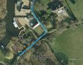
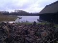
In a reed bed between South Walsham and Ranworth in the Norfolk Broads river and lake system, UK.
Participants
Plans
My planned midnight arrival has been postponed due to thick fog.
This might be close enough to the road for success, I might get rather wet or I could chicken out.
Expedition - Fail
- Arrived. -- Sourcerer (talk) @52.6701,1.5045 13:33, 7 January 2016 (GMT)
Droid said I'd arrived but I'm not claiming this one. All sources indicated that the point was in the reed bed and there was a deep wet drainage ditch between me and the point. I needed to replace my ageing car and I didn't want to fill it with watery mud days before trying to sell it.
Quantum cussedness is working well today. The Friday point looks reachable and is close to this one. This would have made an ideal midnight pair. However I was in the area in daylight today well before the new location was available so that's a missed chance.
Photos
Failure evidence
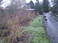
The terrain
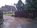
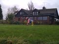
A local house
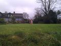
Ape
Ape
South Walsham Broad
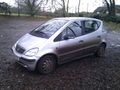
My old car - Bye bye.


Achievements
Expeditions and Plans
| 2016-01-07 | ||
|---|---|---|
| Portland, Oregon | Jim | Private land next to a Demonstration garden |
| Mannheim, Germany | Q-Owl | A meadow near Einhausen |
| Norwich, United Kingdom | Sourcerer | In a reed bed between South Walsham and Ranworth in the Norfolk Broads rive... |
Sourcerer's Expedition Links
2016-01-06 52 1 - 2016-01-07 52 1 - 2016-01-08 52 1 - KML file download of Sourcerer's expeditions for use with Google Earth.