Difference between revisions of "2016-01-08 52 1"
From Geohashing
imported>Sourcerer m (→Planning) |
imported>FippeBot m (Location) |
||
| (3 intermediate revisions by one other user not shown) | |||
| Line 21: | Line 21: | ||
== Expedition == | == Expedition == | ||
| − | + | There was a place to park in the side road near the church. The hashpoint was in a ploughed field, close to the perimeter. My arrival was ahead of time. The sky was clear with lots of stars. | |
== Photos == | == Photos == | ||
<gallery perrow=4> | <gallery perrow=4> | ||
| + | Image:2016-01-08_52_1_Sourcerer_1452292437206.jpg | Arrival proof. [http://www.openstreetmap.org/?lat=52.67379463&lon=1.59520626&zoom=16&layers=B000FTF @52.6738,1.5952] | ||
| + | Image:2016-01-08_52_1_Sourcerer.jpg | Google Earth Track | ||
</gallery> | </gallery> | ||
| Line 37: | Line 39: | ||
}} | }} | ||
| − | |||
| − | |||
[[Category:Expeditions]] | [[Category:Expeditions]] | ||
[[Category:Expeditions with photos]] | [[Category:Expeditions with photos]] | ||
[[Category:Coordinates reached]] | [[Category:Coordinates reached]] | ||
| − | + | {{location|GB|ENG|NFK}} | |
Latest revision as of 06:26, 15 August 2019
| Fri 8 Jan 2016 in Norwich, UK: 52.6738038, 1.5952132 geohashing.info google osm bing/os kml crox |
Location
1) A field at Clippesby, Norfolk, UK.
Participants
Plans
1 of 2 spanning midnight - 2016-01-08 52 1 - 2016-01-09 52 1 - ETA 22:50.
Expedition
There was a place to park in the side road near the church. The hashpoint was in a ploughed field, close to the perimeter. My arrival was ahead of time. The sky was clear with lots of stars.
Photos
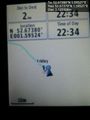
Arrival proof. @52.6738,1.5952
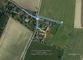
Google Earth Track


Achievements
Expeditions and Plans
| 2016-01-08 | ||
|---|---|---|
| Mannheim, Germany | Q-Owl, DODO | A hashpoint in Bensheim near "Dänisches Bettenlager", behind the "B1" do-it... |
| Norwich, United Kingdom | Sourcerer | 1) A field at Clippesby, Norfolk, UK. |
Sourcerer's Expedition Links
2016-01-07 52 1 - 2016-01-08 52 1 - 2016-01-09 52 1 - KML file download of Sourcerer's expeditions for use with Google Earth.