Difference between revisions of "2016-01-14 52 1"
From Geohashing
imported>Sourcerer m (→New expedition) |
imported>FippeBot m (Location) |
||
| (One intermediate revision by one other user not shown) | |||
| Line 31: | Line 31: | ||
== Achievements == | == Achievements == | ||
{{#vardefine:ribbonwidth|800px}} | {{#vardefine:ribbonwidth|800px}} | ||
| + | |||
| + | {{Midnight geohash | ||
| + | | latitude = 52 | ||
| + | | longitude = 1 | ||
| + | | date = 2016-01-14 | ||
| + | | name = Sourcerer | ||
| + | }} | ||
{{Sourcerer_links | {{Sourcerer_links | ||
| Line 42: | Line 49: | ||
[[Category:Expeditions with photos]] | [[Category:Expeditions with photos]] | ||
[[Category:Coordinates reached]] | [[Category:Coordinates reached]] | ||
| + | {{location|GB|ENG|SFK}} | ||
Latest revision as of 06:28, 15 August 2019
| Thu 14 Jan 2016 in Norwich, UK: 52.3728991, 1.6191584 geohashing.info google osm bing/os kml crox |
Location
A field between Stoven and Frosteden, Suffolk, UK.
Participants
Plans
Expedition 2 of 2 spanning midnight - 2016-01-13 52 1 - 2016-01-14 52 1 - ETA 00:00.
Expedition
This was an almost exact duplicate of the pre-midnight expedition. There was a handy field entrance and even more mud, perhaps not quite as wet. I arrived at the mud pool at three minutes past midnight.
Photos
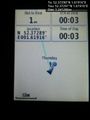
Arrival proof. @52.3729,1.6192
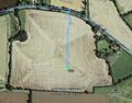
Google Earth Track


Achievements
Sourcerer earned the Midnight Geohash achievement
|
Expeditions and Plans
| 2016-01-14 | ||
|---|---|---|
| Mannheim, Germany | DODO | A field next to the former american casern Patrick-Henry-Village in Heidelb... |
| Kassel, Germany | GeorgDerReisende | The hash lay on the court in front of a house in Staufenberg-Lutterberg. |
| Norwich, United Kingdom | Sourcerer | A field between Stoven and Frosteden, Suffolk, UK. |
Sourcerer's Expedition Links
2016-01-13 52 1 - 2016-01-14 52 1 - 2016-01-15 52 1 - KML file download of Sourcerer's expeditions for use with Google Earth.