Difference between revisions of "2016-01-17 48 8"
imported>Klaus (changed category expedition planning) |
imported>FippeBot m (Location) |
||
| (3 intermediate revisions by one other user not shown) | |||
| Line 1: | Line 1: | ||
| + | [[Image:{{{image|2016-01-17_48_8_view_geohash_4.jpg}}}|thumb|left]] | ||
| − | |||
| − | |||
| − | |||
| − | |||
| − | |||
| − | |||
| − | |||
| − | |||
| − | |||
{{meetup graticule | {{meetup graticule | ||
| lat=48 | | lat=48 | ||
| Line 32: | Line 24: | ||
== Expedition == | == Expedition == | ||
| − | + | tl;dr: Why the f*** did I do this? | |
| + | |||
| + | === The start === | ||
| + | |||
| + | I was lazy in the morning and slept until 10am. | ||
| + | So the original plans was already skewed, but hey, I expect noone to go to this hash anyway so I don't need to be on time. | ||
| + | Furthermore, it was snowing quite strongly at 10am, so actually I ate something and left at around 12:15. | ||
| + | The streets in Tuebingen and until Pfaeffingen were ploughed, and nothing spectacular happened the first 10km or so until Poltringen. | ||
| + | |||
| + | === The way to the geohash === | ||
| − | + | At the end of Poltringen, I turned left at the church and the minor road immediately was covered with 3cm snow, noone ploughs this one. | |
| − | + | Ok, no problem, I have quite new tires, it should be possible to go further. | |
| + | Some 100m later, I was not able to climb the hill any further by cycling, because my backtire had no traction anymore and I was actually standing still will cycling. | ||
| − | + | <gallery> | |
| − | < | + | Image:2016-01-17_48_8_snowy_roads_bicycle.jpg|The hill |
| − | Image: | ||
| − | |||
| − | |||
</gallery> | </gallery> | ||
| − | + | To make things worse, the weather changed each 5min between one of the both: | |
| − | + | Either it was snowing, cold and windy or else the sun came out and my eyes were hurting, because I forgot to bring sunglasses and the snow was reflecting the sunlight. | |
| − | <!-- | + | |
| + | The rest of the way to the geohash was like this, and some time later, the inevitable happened (altough I was driving only like 3km/h): | ||
| + | |||
| + | <gallery> | ||
| + | Image:2016-01-17_48_8_slippy_street.jpg|The marks of a geohasher who decided it was a good idea to cycle on icy roads... | ||
| + | </gallery> | ||
| + | |||
| + | I mainly had to walk most the remaining way because of ice and snow. Half an hour or so later I arrived at the stupidy distance: | ||
| + | |||
| + | <gallery> | ||
| + | Image:2016-01-17_48_8_hill_to_geohash.jpg|Somewhere up there it is! | ||
| + | </gallery> | ||
| + | |||
| + | At the geohash, I took the obligatory photos: | ||
| + | |||
| + | <gallery> | ||
| + | Image:2016-01-17_48_8_proof.jpg|Proof | ||
| + | Image:2016-01-17_48_8_view_geohash_1.jpg|View #1 | ||
| + | Image:2016-01-17_48_8_view_geohash_2.jpg|View #2 | ||
| + | Image:2016-01-17_48_8_view_geohash_3.jpg|View #3 | ||
| + | Image:2016-01-17_48_8_view_geohash_4.jpg|View #4 | ||
| + | Image:2016-01-17_48_8_marker.jpg|Marker | ||
| + | </gallery> | ||
| + | === The way back === | ||
| + | On the way back I thought that it is a much better idea to cycle down to Reusten, because this street is ploughed. | ||
| + | I even spotted some deer crossing the street 10 metres before me: | ||
| + | <gallery> | ||
| + | Image:2016-01-17_48_8_wheres_the_deer.jpg|Where's <s>Waldo</s> the deer? | ||
| + | Image:2016-01-17_48_8_cliffs.jpg|Some nice rocks, like 100m before my tire went flat. | ||
| + | </gallery> | ||
| + | Unfortunately this would have only been a good idea if not somewhere in the "Hailfinger Str." my back tire suddenly went flat... | ||
| + | Damn, not again, just had fixed the flat front tire two days ago and I don't have any repair-stuff with me :( | ||
| − | + | Ok, how do I get back to Tuebingen? Take the bus? No way on a sunday from Reusten. | |
| + | So I actually decided to walk a few kilometers back to Pfaeffingen, where I just wanted to take the train back to Tuebingen. | ||
| − | < | + | <gallery> |
| + | Image:2016-01-17_48_8_snowstorm.jpg|Isn't it fun to walk 5km in this weather :) | ||
| + | Image:2016-01-17_48_8_obligatory_wurmlinger_kapelle.jpg|Obligatory view to "Wurmlinger Kapelle" | ||
| + | </gallery> | ||
| − | + | Luckily, while walking back, I had written Ben (the drag-along from [[2015-11-28 48 9]]) about my failure and as he was near to Pfaeffingen anyway, he picked me up at the station in Pfaeffingen and drove me and my bicycle back home. Thx! | |
| − | [[ | ||
| − | |||
| − | |||
| − | |||
| − | |||
| − | |||
| − | |||
| − | |||
| − | |||
| + | After all, I left at 12:15 and arrived at 15:15 back home. | ||
| − | + | == Achievements == | |
| − | + | {{#vardefine:ribbonwidth|800px}} | |
| − | |||
| − | |||
| − | |||
| − | |||
| − | |||
| − | |||
| − | + | {{land geohash | |
| − | [[ | + | | latitude = 48 |
| − | + | | longitude = 8 | |
| − | + | | date = 2016-01-17 | |
| − | [[ | + | | name = [[User:Klaus|Klaus]] |
| + | }} | ||
| + | {{bicycle geohash | ||
| + | | latitude = 48 | ||
| + | | longitude = 8 | ||
| + | | date = 2016-01-17 | ||
| + | | name = [[User:Klaus|Klaus]] | ||
| + | | distance = 19km | ||
| + | | bothways = true | ||
| + | }} | ||
| + | {{Two to the N achievement | ||
| + | | count = 4 | ||
| + | | date = 2016-01-17 | ||
| + | | latitude = 48 | ||
| + | | longitude = 8 | ||
| + | | name = [[User:Klaus]] | ||
| + | }} | ||
| − | + | [[Category:Expeditions]] | |
| + | [[Category:Expeditions with photos]] | ||
| + | [[Category:Coordinates reached]] | ||
| + | {{location|DE|BW|TÜ}} | ||
Latest revision as of 06:31, 15 August 2019

| Sun 17 Jan 2016 in 48,8: 48.5367424, 8.9107625 geohashing.info google osm bing/os kml crox |
Location
Reusten, Germany
Participants
Plans
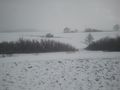
This one is near to a nice area (German wiki has pictures) where I wasn't before. I'll cycle there in the morning starting around 10:00, so I'll arrive around 11:00. If it's too stormy and snowy in the morning, I might not attempt it.
Hopefully the valley is nice in winter, too :)
Expedition
tl;dr: Why the f*** did I do this?
The start
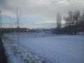
I was lazy in the morning and slept until 10am. So the original plans was already skewed, but hey, I expect noone to go to this hash anyway so I don't need to be on time. Furthermore, it was snowing quite strongly at 10am, so actually I ate something and left at around 12:15. The streets in Tuebingen and until Pfaeffingen were ploughed, and nothing spectacular happened the first 10km or so until Poltringen.
The way to the geohash
At the end of Poltringen, I turned left at the church and the minor road immediately was covered with 3cm snow, noone ploughs this one. Ok, no problem, I have quite new tires, it should be possible to go further. Some 100m later, I was not able to climb the hill any further by cycling, because my backtire had no traction anymore and I was actually standing still will cycling.
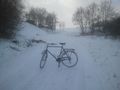
The hill

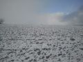
To make things worse, the weather changed each 5min between one of the both: Either it was snowing, cold and windy or else the sun came out and my eyes were hurting, because I forgot to bring sunglasses and the snow was reflecting the sunlight.
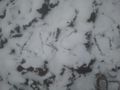
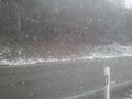
The rest of the way to the geohash was like this, and some time later, the inevitable happened (altough I was driving only like 3km/h):
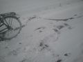
The marks of a geohasher who decided it was a good idea to cycle on icy roads...

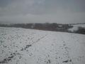
I mainly had to walk most the remaining way because of ice and snow. Half an hour or so later I arrived at the stupidy distance:
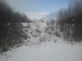
Somewhere up there it is!

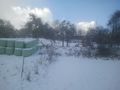
At the geohash, I took the obligatory photos:

Proof
View #1
View #2
View #3
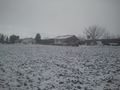
View #4
Marker


The way back
On the way back I thought that it is a much better idea to cycle down to Reusten, because this street is ploughed. I even spotted some deer crossing the street 10 metres before me:
Where's
Waldothe deer?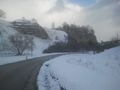
Some nice rocks, like 100m before my tire went flat.


Unfortunately this would have only been a good idea if not somewhere in the "Hailfinger Str." my back tire suddenly went flat... Damn, not again, just had fixed the flat front tire two days ago and I don't have any repair-stuff with me :(
Ok, how do I get back to Tuebingen? Take the bus? No way on a sunday from Reusten. So I actually decided to walk a few kilometers back to Pfaeffingen, where I just wanted to take the train back to Tuebingen.
Isn't it fun to walk 5km in this weather :)
Obligatory view to "Wurmlinger Kapelle"


Luckily, while walking back, I had written Ben (the drag-along from 2015-11-28 48 9) about my failure and as he was near to Pfaeffingen anyway, he picked me up at the station in Pfaeffingen and drove me and my bicycle back home. Thx!
After all, I left at 12:15 and arrived at 15:15 back home.
Achievements
Klaus earned the Land geohash achievement
|
Klaus earned the Bicycle geohash achievement
|
