Difference between revisions of "2016-01-24 47 -122"
imported>Thomcat ([live picture]Post hash refreshment [http://www.openstreetmap.org/?lat=47.91070540&lon=-122.22495020&zoom=16&layers=B000FTF @47.9107,-122.2250]) |
imported>Thomcat |
||
| Line 13: | Line 13: | ||
| lon=-122 | | lon=-122 | ||
| date=2016-01-24 | | date=2016-01-24 | ||
| + | | graticule_name=Seattle | ||
| + | | graticule_link=Seattle, Washington | ||
}} | }} | ||
| Line 19: | Line 21: | ||
== Location == | == Location == | ||
| − | + | Near a Texaco station just north of Silver Lake in Everett. | |
== Participants == | == Participants == | ||
| − | + | * [[User:Thomcat|Thomcat]] | |
| − | |||
== Plans == | == Plans == | ||
| Line 29: | Line 30: | ||
== Expedition == | == Expedition == | ||
| − | + | Got a lot of housework taken care of on Sunday and figured I had time for a geohash. A short drive up the freeway to Everett deposited me just south of Silver Lake, which I circumvented to reach the hashpoint. | |
| + | |||
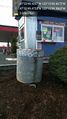
| + | When I first opened up the droid, it found the hashpoint on the edge of the road, near the foundation of a light standard and just meters away from a coffee stand. I decorated the side of this with sidewalk chalk and snapped a picture. | ||
| + | |||
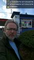
| + | Going for the wiki upload, the point was now a meter or so off the curb in the other direction - a relatively busy road. I snapped a selfie and proceeded to upload both. | ||
| + | |||
| + | Following this, I drove a short distance north (but out of visual range, so no pub award here) and had a pint while watching the last 10 suspenseful minutes of the AFC championship game (NFL). | ||
== Tracklog == | == Tracklog == | ||
| Line 53: | Line 60: | ||
<!-- Add any achievement ribbons you earned below, or remove this section --> | <!-- Add any achievement ribbons you earned below, or remove this section --> | ||
| − | |||
| − | |||
| − | |||
| − | |||
| − | |||
| − | |||
| − | |||
| − | |||
| − | |||
| − | |||
| − | |||
| − | |||
[[Category:Expeditions]] | [[Category:Expeditions]] | ||
| − | |||
[[Category:Expeditions with photos]] | [[Category:Expeditions with photos]] | ||
| − | |||
| − | |||
| − | |||
| − | |||
| − | |||
[[Category:Coordinates reached]] | [[Category:Coordinates reached]] | ||
| − | |||
| − | |||
| − | |||
| − | |||
| − | |||
| − | |||
| − | |||
| − | |||
| − | |||
| − | |||
| − | |||
| − | |||
| − | |||
| − | |||
| − | |||
| − | |||
| − | |||
| − | |||
Revision as of 14:45, 25 January 2016
| Sun 24 Jan 2016 in Seattle: 47.8970627, -122.2109631 geohashing.info google osm bing/os kml crox |
Location
Near a Texaco station just north of Silver Lake in Everett.
Participants
Plans
Expedition
Got a lot of housework taken care of on Sunday and figured I had time for a geohash. A short drive up the freeway to Everett deposited me just south of Silver Lake, which I circumvented to reach the hashpoint.
When I first opened up the droid, it found the hashpoint on the edge of the road, near the foundation of a light standard and just meters away from a coffee stand. I decorated the side of this with sidewalk chalk and snapped a picture.
Going for the wiki upload, the point was now a meter or so off the curb in the other direction - a relatively busy road. I snapped a selfie and proceeded to upload both.
Following this, I drove a short distance north (but out of visual range, so no pub award here) and had a pint while watching the last 10 suspenseful minutes of the AFC championship game (NFL).
Tracklog
Photos
Here @47.8971,-122.2110
Geohasher @47.8971,-122.2110
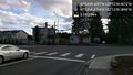
Intersection @47.8971,-122.2109
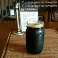
Post hash refreshment @47.9107,-122.2250


