Difference between revisions of "2016-02-05 47 -122"
From Geohashing
imported>Thomcat (An expedition message sent via Geohash Droid for Android.) |
imported>FippeBot m (Location) |
||
| (4 intermediate revisions by one other user not shown) | |||
| Line 13: | Line 13: | ||
| lon=-122 | | lon=-122 | ||
| date=2016-02-05 | | date=2016-02-05 | ||
| + | | graticule_name=Seattle | ||
| + | | graticule_link=Seattle, Washington | ||
}} | }} | ||
| Line 19: | Line 21: | ||
== Location == | == Location == | ||
| − | + | Holyrood cemetery | |
== Participants == | == Participants == | ||
<!-- who attended: If you link to your wiki user name in this section, your expedition will be picked up by the various statistics generated for geohashing. You may use three tildes ~ as a shortcut to automatically insert the user signature of the account you are editing with. | <!-- who attended: If you link to your wiki user name in this section, your expedition will be picked up by the various statistics generated for geohashing. You may use three tildes ~ as a shortcut to automatically insert the user signature of the account you are editing with. | ||
--> | --> | ||
| + | * [[User:Thomcat|Thomcat]] | ||
== Plans == | == Plans == | ||
| Line 29: | Line 32: | ||
== Expedition == | == Expedition == | ||
| − | + | A day off with plans to visit the transfer station and dump 140 pounds of refuse, along with a nearby Costco. The cemetery was basically on the route and open. | |
| + | |||
| + | While someday a geohasher may reach their final couch potato at this location, it is now an empty field for future expansion. | ||
| + | |||
| + | After achieving the geohashpoint, I left behind the tranquility to continue my errands. | ||
== Tracklog == | == Tracklog == | ||
| Line 39: | Line 46: | ||
--> | --> | ||
<gallery perrow="5"> | <gallery perrow="5"> | ||
| + | |||
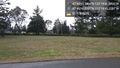
| + | Image:2016-02-05_47_-122_thomcat_1454702013041.jpg|Future past geohasher [http://www.openstreetmap.org/?lat=47.77127020&lon=-122.32868280&zoom=16&layers=B000FTF @47.7713,-122.3287] | ||
| + | |||
| + | Image:2016-02-05_47_-122_thomcat_1454702247924.jpg|Present geohasher [http://www.openstreetmap.org/?lat=47.77089480&lon=-122.32826440&zoom=16&layers=B000FTF @47.7709,-122.3283] | ||
| + | |||
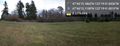
| + | Image:2016-02-05_47_-122_thomcat_1454702355707.jpg|Panorama [http://www.openstreetmap.org/?lat=47.77086660&lon=-122.32827830&zoom=16&layers=B000FTF @47.7709,-122.3283] | ||
</gallery> | </gallery> | ||
| Line 45: | Line 58: | ||
<!-- Add any achievement ribbons you earned below, or remove this section --> | <!-- Add any achievement ribbons you earned below, or remove this section --> | ||
| − | |||
| − | |||
| − | |||
| − | |||
| − | |||
| − | |||
| − | |||
| − | |||
| − | |||
| − | |||
| − | |||
| − | |||
[[Category:Expeditions]] | [[Category:Expeditions]] | ||
| − | |||
[[Category:Expeditions with photos]] | [[Category:Expeditions with photos]] | ||
| − | |||
| − | |||
| − | |||
| − | |||
| − | |||
[[Category:Coordinates reached]] | [[Category:Coordinates reached]] | ||
| − | + | {{location|US|WA|KN}} | |
| − | |||
| − | |||
| − | |||
| − | |||
| − | |||
| − | |||
| − | |||
| − | |||
| − | |||
| − | |||
| − | |||
| − | |||
| − | |||
| − | |||
| − | |||
| − | |||
| − | |||
Latest revision as of 06:38, 15 August 2019
| Fri 5 Feb 2016 in Seattle: 47.7708850, -122.3282899 geohashing.info google osm bing/os kml crox |
Location
Holyrood cemetery
Participants
Plans
Expedition
A day off with plans to visit the transfer station and dump 140 pounds of refuse, along with a nearby Costco. The cemetery was basically on the route and open.
While someday a geohasher may reach their final couch potato at this location, it is now an empty field for future expansion.
After achieving the geohashpoint, I left behind the tranquility to continue my errands.
Tracklog
Photos
Future past geohasher @47.7713,-122.3287

Present geohasher @47.7709,-122.3283
Panorama @47.7709,-122.3283

