Difference between revisions of "2016-02-12 52 -1"
imported>Pbro (→Achievements) |
imported>Pbro |
||
| Line 17: | Line 17: | ||
<!-- edit as necessary --> | <!-- edit as necessary --> | ||
__NOTOC__ | __NOTOC__ | ||
| + | [[User:Pbro|Pbro]] ([[User talk:Pbro|talk]]) detoured on his cycle commute past this central divider hash. | ||
== Location == | == Location == | ||
| Line 37: | Line 38: | ||
--> | --> | ||
<gallery perrow="5"> | <gallery perrow="5"> | ||
| + | Image:2016_02_12_52_-1_Bush.jpg | Not climbing in there | ||
| + | Image:2016_02_12_52_-1_Opp.jpg | House with view of a hash | ||
| + | Image:2016_02_12_52_-1_AOR1.jpg | The road from Birmingham | ||
| + | Image:2016_02_12_52_-1_AOR2.jpg | Beautiful morning | ||
| + | Image:2016_02_12_52_-1_Selfie.jpg | Bicycle hash! | ||
| + | Image:Screenshot_2016_02_12_52_-1.png | Phone believes I'm there | ||
</gallery> | </gallery> | ||
| Line 47: | Line 54: | ||
| longitude = -1 | | longitude = -1 | ||
| date = 2016-02-12 | | date = 2016-02-12 | ||
| − | | name = Pbro | + | | name = [[User:Pbro|Pbro]] |
| distance = 2.6 km | | distance = 2.6 km | ||
| − | | | + | | image = 2016_02_12_52_-1_Selfie.jpg |
}} | }} | ||
| Line 59: | Line 66: | ||
| latitude = 52 | | latitude = 52 | ||
| longitude = -1 | | longitude = -1 | ||
| − | | name = Pbro | + | | reached = true |
| + | | name = [[User:Pbro|Pbro]] | ||
}} | }} | ||
Revision as of 23:04, 3 March 2016
| Fri 12 Feb 2016 in 52,-1: 52.4185127, -1.5528699 geohashing.info google osm bing/os kml crox |
Pbro (talk) detoured on his cycle commute past this central divider hash.
Location
In the bushes in the wide central divider of Allesley Old Road (opposite 618 Allesley Old Road, CV5 8GB), Coventry, close to the junction with Holyhead Road.
Participants
Pbro (talk) -- detoured on his bicycle on his way to work.
Expedition
Pbro (talk) finally found another hash in bicycle distance from home. Decided to stop by on glorious morning on the way to work (10 min detour). The hash was easily accessible, located on an overgrown central divider where Allesley Old Road is a dual carriageway. I first stopped my bicycle on the northbound side of the divider and headed into the undergrowth along a footpath, but could not get close. After checking the exact location on my mobile, I rode around the divider to the southbound side. The exact hash was in a blackberry thicket just opposite 618 Allesley Old Road. After making sure that I had reached the hash to within GPS precision, I rode back down Allesley Old Road, just to remember that I wanted to take a hash selfie. So back up the hill, another pic, and off to work.
The same evening, I fell of my bicycle on the way home, fractured my wrist and thus did not get to report this hash until much later...
Tracklog
Battery failure in my tracking GPS device (or rather charging failure on my side). So no track log.
Photos
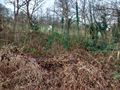
Not climbing in there

House with view of a hash
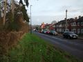
The road from Birmingham
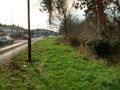
Beautiful morning

Bicycle hash!
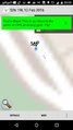
Phone believes I'm there


Achievements
Pbro earned the Bicycle geohash achievement
|
