Difference between revisions of "2016-02-12 52 9"
From Geohashing
imported>Fippe |
m (Adding hours) |
||
| (5 intermediate revisions by 3 users not shown) | |||
| Line 8: | Line 8: | ||
==Location== | ==Location== | ||
| − | The Geohash is located the Blauer See and the Leine in [[wikipedia:Garbsen|Garbsen]]. | + | The Geohash is located between the Blauer See and the Leine in [[wikipedia:Garbsen|Garbsen]]. |
==Participants== | ==Participants== | ||
| Line 29: | Line 29: | ||
==Achievements== | ==Achievements== | ||
| − | {{#vardefine:ribbonwidth| | + | {{#vardefine:ribbonwidth|100%}} |
| − | {{land geohash|latitude=52|longitude=9|date=2016- | + | {{land geohash|latitude=52|longitude=9|date=2016-02-12|name=[[User:Fippe|Fippe]]|image=2016-02-12 52 09 07 Geohash.jpg}} |
__NOTOC__ | __NOTOC__ | ||
| Line 36: | Line 36: | ||
[[Category:Coordinates reached]] | [[Category:Coordinates reached]] | ||
[[Category:Expeditions with photos]] | [[Category:Expeditions with photos]] | ||
| + | {{location|DE|NI|H}} | ||
| + | {{user categories|user=Fippe|bus=31|foot=5|hours=18}} | ||
Latest revision as of 19:06, 11 December 2022
| Fri 12 Feb 2016 in Hannover: 52.4185127, 9.5528699 geohashing.info google osm bing/os kml crox |
Location
The Geohash is located between the Blauer See and the Leine in Garbsen.
Participants
Expedition
I took the bus to Lohnde. From there, I walked to the hash in Garbsen. I found it right in-between the river Leine, which is meandering around over there, and a pond, the Blauer See.
Photos


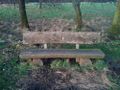
A Bench in Garbsen
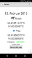
Proof
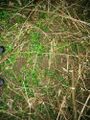
The Geohash
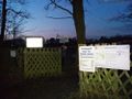
Entry to the Blauer See.


Achievements
Fippe earned the Land geohash achievement
|