Difference between revisions of "2016-02-13 52 1"
From Geohashing
imported>Sourcerer (→Planning) |
imported>Sourcerer m ([live picture] Arrival proof. [http://www.openstreetmap.org/?lat=52.71195173&lon=1.44526541&zoom=16&layers=B000FTF @52.7120,1.4453]) |
||
| Line 25: | Line 25: | ||
== Photos == | == Photos == | ||
<gallery perrow=4> | <gallery perrow=4> | ||
| + | |||
| + | Image:2016-02-13_52_1_Sourcerer_1455321522485.jpg | Arrival proof. [http://www.openstreetmap.org/?lat=52.71195173&lon=1.44526541&zoom=16&layers=B000FTF @52.7120,1.4453] | ||
</gallery> | </gallery> | ||
Revision as of 00:00, 13 February 2016
| Sat 13 Feb 2016 in Norwich, UK: 52.7118780, 1.4452625 geohashing.info google osm bing/os kml crox |
Location
A wood between Hoveton and Horning, Norfolk, UK.
Participants
Plans
Two of two spanning midnight - 2016-02-12 52 1 - 2016-02-13 52 1 - ETA 00:00.
Expedition
Photos
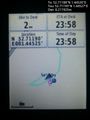
Arrival proof. @52.7120,1.4453

Achievements
Expeditions and Plans
| 2016-02-13 | ||
|---|---|---|
| Concord, New Hampshire | Someone went | Somewhere near Center Harbor/Moultonborough line - North of Gifford |
| Innsbruck, Austria | TheOneRing | in a forest near Benediktbeuern. |
| Norwich, United Kingdom | Sourcerer | A wood between Hoveton and Horning, Norfolk, UK. |
Sourcerer's Expedition Links
2016-02-12 52 1 - 2016-02-13 52 1 - 2016-02-14 52 1 - KML file download of Sourcerer's expeditions for use with Google Earth.