Difference between revisions of "2016-02-19 42 -73"
imported>SlumberBear (Created page with "{{subst:Expedition |lat = 42 |lon = -73 |date = 2016-02-19 }}") |
imported>FippeBot m (Location) |
||
| (2 intermediate revisions by one other user not shown) | |||
| Line 1: | Line 1: | ||
| − | |||
| − | |||
| − | |||
| − | |||
| − | |||
| − | |||
| − | |||
| − | |||
| − | |||
| − | |||
{{meetup graticule | {{meetup graticule | ||
| lat=42 | | lat=42 | ||
| Line 14: | Line 4: | ||
| date=2016-02-19 | | date=2016-02-19 | ||
}} | }} | ||
| − | |||
| − | |||
| − | |||
== Location == | == Location == | ||
| − | + | In the woods between Rt. 8 and Outlook Ave. | |
== Participants == | == Participants == | ||
| − | + | [[User:SlumberBear|SlumberBear]] ([[User talk:SlumberBear|talk]]) | |
| − | |||
| − | |||
| − | |||
| − | |||
== Expedition == | == Expedition == | ||
| − | + | We decided to make this stop while on a Geocaching and antiquing trip through the mountains. When we reached Outlook Ave., we realized that the walk would be a bit longer than we thought. But we had come that far, so we had to continue. After crossing through a field, we came upon a clearing made for the gas pipeline, and followed it to the area of the hash. Then we cut off the clearing (for only a few hundred feet) to get into the vicinity. Success! And we never crossed any No Trespassing signs, so we're calling our expedition "legal." | |
| − | |||
| − | |||
| − | |||
== Photos == | == Photos == | ||
| − | < | + | <gallery perrow> |
| − | Image: | + | Image: 2016-02-19 field.JPG | The field we crossed. |
| − | -- | + | Image: 2016-02-19 pipeline.JPG | Our free passage through the woods. |
| − | + | Image: 2016-02-19 pano.JPG | A panorama of the geohash spot. The woods were beautiful. | |
| + | Image: 2016-02-19 grin.JPG | Obligitory. | ||
| + | Image: 2016-02-19 map.PNG | Proof. The phone was well within its accuracy field. | ||
</gallery> | </gallery> | ||
== Achievements == | == Achievements == | ||
{{#vardefine:ribbonwidth|800px}} | {{#vardefine:ribbonwidth|800px}} | ||
| − | + | {{Two to the N achievement | count = 1 | latitude = 42 | longitude = -73 | date = 2016-02-19 | name = SlumberBear }} | |
| − | |||
| − | |||
| − | |||
| − | |||
| − | |||
| − | |||
| − | |||
| − | |||
| − | |||
| − | |||
| − | |||
| − | |||
[[Category:Expeditions]] | [[Category:Expeditions]] | ||
| − | |||
[[Category:Expeditions with photos]] | [[Category:Expeditions with photos]] | ||
| − | |||
| − | |||
| − | |||
| − | |||
| − | |||
[[Category:Coordinates reached]] | [[Category:Coordinates reached]] | ||
| − | + | [[Category: Meetup on 2016-02-19]] | |
| − | + | [[Category: Meetup in 42 -73]] | |
| − | + | {{location|US|MA|BE}} | |
| − | [[Category: | ||
| − | |||
| − | |||
| − | |||
| − | |||
| − | |||
| − | [[Category: | ||
| − | |||
| − | |||
| − | |||
| − | |||
| − | |||
| − | |||
| − | |||
| − | |||
Latest revision as of 01:38, 7 August 2019
| Fri 19 Feb 2016 in 42,-73: 42.5802651, -73.1581315 geohashing.info google osm bing/os kml crox |
Location
In the woods between Rt. 8 and Outlook Ave.
Participants
Expedition
We decided to make this stop while on a Geocaching and antiquing trip through the mountains. When we reached Outlook Ave., we realized that the walk would be a bit longer than we thought. But we had come that far, so we had to continue. After crossing through a field, we came upon a clearing made for the gas pipeline, and followed it to the area of the hash. Then we cut off the clearing (for only a few hundred feet) to get into the vicinity. Success! And we never crossed any No Trespassing signs, so we're calling our expedition "legal."
Photos
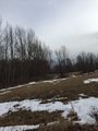
The field we crossed.
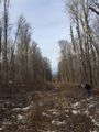
Our free passage through the woods.
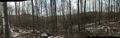
A panorama of the geohash spot. The woods were beautiful.

Obligitory.
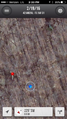
Proof. The phone was well within its accuracy field.


Achievements
