Difference between revisions of "2016-02-23 49 8"
imported>DODO (→Achievements) |
m (Location correction) |
||
| (4 intermediate revisions by 3 users not shown) | |||
| Line 15: | Line 15: | ||
}} | }} | ||
| − | + | ||
__NOTOC__ | __NOTOC__ | ||
== Location == | == Location == | ||
| − | + | ||
In the forest near Iggelheim | In the forest near Iggelheim | ||
== Participants == | == Participants == | ||
| − | + | ||
| − | + | * [[User:DODO|DODO]] | |
| − | [[User:DODO|DODO]] | ||
== Plans == | == Plans == | ||
| − | + | ||
Drive by on my way to the office. | Drive by on my way to the office. | ||
== Expedition == | == Expedition == | ||
| − | + | ||
I had to go to work by car today and so the plan was to drive as close to the hash as possible, walk the rest of the way and continue my way to the office. There was a big surprise when I woke up in the morning: it was heavily snowing outside (so I would have driven by car anyway). | I had to go to work by car today and so the plan was to drive as close to the hash as possible, walk the rest of the way and continue my way to the office. There was a big surprise when I woke up in the morning: it was heavily snowing outside (so I would have driven by car anyway). | ||
| − | The hash was close to the Waldsiedlung "Am Waldend" (forest settlement "At the end of the forest"). I left the car at the end of the forest and started walking. The world had changed into a winter wonderland and I enjoyed the walk very much. I had the first view to the hash after ten minutes. Perception wasn't | + | The hash was close to the Waldsiedlung "Am Waldend" (forest settlement "At the end of the forest"). I left the car at the end of the forest and started walking. |
| + | The world had changed into a winter wonderland and I enjoyed the walk very much. I had the first view to the hash after ten minutes. | ||
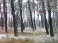
| + | Perception wasn't too good in the forest with the dense snow, so I had to do some dancing, but in the end I got two acceptable proofs. | ||
| + | I returned to my car and continued the drive to the office. | ||
All in all it was a 49 KM drive and 2 KM of walking. As the way to the office is 25 KM, it was a acceptable violation of my fuel policy (not more than 20 KM of car driving for a hash). | All in all it was a 49 KM drive and 2 KM of walking. As the way to the office is 25 KM, it was a acceptable violation of my fuel policy (not more than 20 KM of car driving for a hash). | ||
== Tracklog == | == Tracklog == | ||
| − | + | ||
| + | [https://www.komoot.de/tour/7932488 49 KM by car and 2 KM by foot] | ||
== Photos == | == Photos == | ||
| − | + | ||
| − | |||
| − | |||
<gallery perrow="4"> | <gallery perrow="4"> | ||
Image:2016-02-23_49_8-1.jpg|Where I left little car | Image:2016-02-23_49_8-1.jpg|Where I left little car | ||
| Line 59: | Line 60: | ||
== Achievements == | == Achievements == | ||
{{#vardefine:ribbonwidth|800px}} | {{#vardefine:ribbonwidth|800px}} | ||
| − | |||
{{land geohash | {{land geohash | ||
| Line 67: | Line 67: | ||
| name = DODO | | name = DODO | ||
}} | }} | ||
| + | |||
| + | It's my 100th successful geohash. So just 28 more for level 7 :-) | ||
| + | And it's my first successful hash in Bad Dürkheim. | ||
[[Category:Expeditions]] | [[Category:Expeditions]] | ||
| − | |||
[[Category:Expeditions with photos]] | [[Category:Expeditions with photos]] | ||
| − | |||
[[Category:Coordinates reached]] | [[Category:Coordinates reached]] | ||
| + | {{location|DE|RP|DÜW}} | ||
Latest revision as of 20:31, 16 May 2020
| Tue 23 Feb 2016 in 49,8: 49.3429322, 8.3012656 geohashing.info google osm bing/os kml crox |
Location
In the forest near Iggelheim
Participants
Plans
Drive by on my way to the office.
Expedition
I had to go to work by car today and so the plan was to drive as close to the hash as possible, walk the rest of the way and continue my way to the office. There was a big surprise when I woke up in the morning: it was heavily snowing outside (so I would have driven by car anyway).
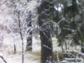
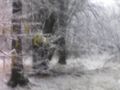
The hash was close to the Waldsiedlung "Am Waldend" (forest settlement "At the end of the forest"). I left the car at the end of the forest and started walking. The world had changed into a winter wonderland and I enjoyed the walk very much. I had the first view to the hash after ten minutes. Perception wasn't too good in the forest with the dense snow, so I had to do some dancing, but in the end I got two acceptable proofs. I returned to my car and continued the drive to the office.
All in all it was a 49 KM drive and 2 KM of walking. As the way to the office is 25 KM, it was a acceptable violation of my fuel policy (not more than 20 KM of car driving for a hash).
Tracklog
Photos
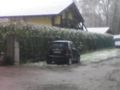
Where I left little car
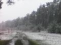
winter wonderland
first view to the hashes direction
first proof

second proof

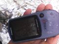
obligatory
view from the hash
in the other direction


Achievements
DODO earned the Land geohash achievement
|
It's my 100th successful geohash. So just 28 more for level 7 :-) And it's my first successful hash in Bad Dürkheim.