Difference between revisions of "2016-02-24 52 1"
From Geohashing
imported>Sourcerer m (→New expedition) |
imported>FippeBot m (Location) |
||
| (4 intermediate revisions by one other user not shown) | |||
| Line 22: | Line 22: | ||
There was a dry field entrance to park and a 60 metre walk over a grassy meadow to reach the moonlit hashpoint. A fox was making crying/barking noises in the distance. A ghostly owl flew past. | There was a dry field entrance to park and a 60 metre walk over a grassy meadow to reach the moonlit hashpoint. A fox was making crying/barking noises in the distance. A ghostly owl flew past. | ||
| + | |||
| + | I had planned to make a retro visit to [[2015-04-10 52 1]], only 45 metres from the road and about 500 metres from today's point. There was deep mud and I was feeling tired so I didn't bother. | ||
== Photos == | == Photos == | ||
| Line 27: | Line 29: | ||
Image:2016-02-24_52_1_Sourcerer_1456272041804.jpg | Arrival proof. [http://www.openstreetmap.org/?lat=52.73644567&lon=1.10599816&zoom=16&layers=B000FTF @52.7364,1.1060] | Image:2016-02-24_52_1_Sourcerer_1456272041804.jpg | Arrival proof. [http://www.openstreetmap.org/?lat=52.73644567&lon=1.10599816&zoom=16&layers=B000FTF @52.7364,1.1060] | ||
Image:2016-02-24_52_1_Sourcerer.jpg | Google Earth Track | Image:2016-02-24_52_1_Sourcerer.jpg | Google Earth Track | ||
| + | 2016-02-24 52 1 Sourcerer Retro.jpg | Abandoned Retro | ||
</gallery> | </gallery> | ||
== Achievements == | == Achievements == | ||
{{#vardefine:ribbonwidth|800px}} | {{#vardefine:ribbonwidth|800px}} | ||
| + | |||
| + | {{Frozen Geohash | ||
| + | | latitude = 52 | ||
| + | | longitude = 1 | ||
| + | | date = 2016-02-24 | ||
| + | | name = Sourcerer | ||
| + | | temperature = -1.5°C | ||
| + | }} | ||
| + | {{Midnight geohash | ||
| + | | latitude = 52 | ||
| + | | longitude = 1 | ||
| + | | date = 2016-02-24 | ||
| + | | name = Sourcerer | ||
| + | }} | ||
{{Sourcerer_links | {{Sourcerer_links | ||
| prev = 2016-02-23 52 1 | | prev = 2016-02-23 52 1 | ||
| curr = 2016-02-24 52 1 | | curr = 2016-02-24 52 1 | ||
| − | | next = 2016-02- | + | | next = 2016-02-26 52 1 |
| date = 2016-02-24 | | date = 2016-02-24 | ||
}} | }} | ||
| Line 42: | Line 59: | ||
[[Category:Expeditions with photos]] | [[Category:Expeditions with photos]] | ||
[[Category:Coordinates reached]] | [[Category:Coordinates reached]] | ||
| + | {{location|GB|ENG|NFK}} | ||
Latest revision as of 06:46, 15 August 2019
| Wed 24 Feb 2016 in Norwich, UK: 52.7364653, 1.1060463 geohashing.info google osm bing/os kml crox |
Location
A field north of Great Witchingham, Norfolk, UK.
Participants
Plans
Two of two spanning midnight - 2016-02-23 52 1 - 2016-02-24 52 1 - ETA 00:00.
Expedition
There was a dry field entrance to park and a 60 metre walk over a grassy meadow to reach the moonlit hashpoint. A fox was making crying/barking noises in the distance. A ghostly owl flew past.
I had planned to make a retro visit to 2015-04-10 52 1, only 45 metres from the road and about 500 metres from today's point. There was deep mud and I was feeling tired so I didn't bother.
Photos

Arrival proof. @52.7364,1.1060
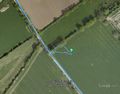
Google Earth Track
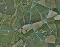
Abandoned Retro


Achievements

Sourcerer earned the Frozen Geohash Achievement
by reaching the (52, 1) geohash on 2016-02-24 while the temperature was -1.5°C.
Sourcerer earned the Midnight Geohash achievement
|
Expeditions and Plans
| 2016-02-24 | ||
|---|---|---|
| Bonn, Germany | Burgman | Just in front of the Bonn Opera. |
| Norwich, United Kingdom | Sourcerer | A field north of Great Witchingham, Norfolk, UK. |
Sourcerer's Expedition Links
2016-02-23 52 1 - 2016-02-24 52 1 - 2016-02-26 52 1 - KML file download of Sourcerer's expeditions for use with Google Earth.