Difference between revisions of "2016-03-07 52 1"
From Geohashing
imported>Sourcerer m ([live picture] Foiled. [http://www.openstreetmap.org/?lat=52.35981524&lon=1.10454977&zoom=16&layers=B000FTF @52.3598,1.1045]) |
m |
||
| (6 intermediate revisions by 2 users not shown) | |||
| Line 1: | Line 1: | ||
| − | + | {{meetup graticule | |
| − | |||
| − | |||
| − | |||
| − | |||
| − | |||
| − | |||
| − | |||
| − | |||
| − | |||
| − | {{meetup graticule | ||
| lat=52 | | lat=52 | ||
| lon=1 | | lon=1 | ||
| date=2016-03-07 | | date=2016-03-07 | ||
| + | | graticule_name=Norwich, UK | ||
| + | | graticule_link=Norwich, United Kingdom | ||
}} | }} | ||
| + | __NOTOC__ | ||
| + | == Location == | ||
| − | + | A field edge at Palgrave south of Diss, just over the border in Suffolk, UK. | |
| − | |||
| − | == | + | == Participants == |
| − | |||
| − | + | [[User:Sourcerer|Sourcerer]] | |
| − | |||
| − | |||
== Plans == | == Plans == | ||
| − | |||
| − | + | This was only 400 metres off the track I was already travelling so it had to be tried. | |
| − | |||
| − | == | + | == Expedition - Fail == |
| − | |||
| − | + | Several approaches were tried. The final and closest approach got to 7 or 8 metres away but the hashpoint was on the wrong side of a dense hedge. Foiled! | |
| − | |||
| − | |||
| − | |||
| − | |||
| + | == Photos == | ||
| + | <gallery perrow=2> | ||
Image:2016-03-07_52_1_Sourcerer_1457357150867.jpg | Foiled. [http://www.openstreetmap.org/?lat=52.35981524&lon=1.10454977&zoom=16&layers=B000FTF @52.3598,1.1045] | Image:2016-03-07_52_1_Sourcerer_1457357150867.jpg | Foiled. [http://www.openstreetmap.org/?lat=52.35981524&lon=1.10454977&zoom=16&layers=B000FTF @52.3598,1.1045] | ||
| + | |||
| + | Image:2016-03-07_52_1_Sourcerer_1457357176374.jpg | Rabbit fence. [http://www.openstreetmap.org/?lat=52.35981524&lon=1.10454977&zoom=16&layers=B000FTF @52.3598,1.1045] | ||
| + | |||
| + | Image:2016-03-07_52_1_Sourcerer_1457357170490.jpg | Rabbit fence. [http://www.openstreetmap.org/?lat=52.35981524&lon=1.10454977&zoom=16&layers=B000FTF @52.3598,1.1045] | ||
| + | |||
| + | Image:2016-03-07_52_1_Sourcerer.jpg | Google Earth Track | ||
</gallery> | </gallery> | ||
== Achievements == | == Achievements == | ||
{{#vardefine:ribbonwidth|800px}} | {{#vardefine:ribbonwidth|800px}} | ||
| − | |||
| − | + | {{Sourcerer_links | |
| − | + | | prev = 2016-03-01 52 1 | |
| − | + | | curr = 2016-03-07 52 1 | |
| + | | next = 2016-03-14 51 0 | ||
| + | | date = 2016-03-07 | ||
| + | }} | ||
| − | |||
| − | |||
| − | |||
| − | |||
| − | |||
| − | |||
| − | |||
| − | |||
[[Category:Expeditions]] | [[Category:Expeditions]] | ||
| − | |||
[[Category:Expeditions with photos]] | [[Category:Expeditions with photos]] | ||
| − | |||
| − | |||
| − | |||
| − | |||
| − | |||
| − | |||
| − | |||
| − | |||
| − | |||
[[Category:Coordinates not reached]] | [[Category:Coordinates not reached]] | ||
| − | |||
| − | |||
| − | |||
| − | |||
| − | |||
[[Category:Not reached - No public access]] | [[Category:Not reached - No public access]] | ||
| − | + | {{location|GB|ENG|SFK}} | |
| − | |||
| − | |||
| − | |||
| − | |||
| − | |||
| − | |||
| − | |||
Latest revision as of 11:54, 27 March 2022
| Mon 7 Mar 2016 in Norwich, UK: 52.3598813, 1.1045388 geohashing.info google osm bing/os kml crox |
Location
A field edge at Palgrave south of Diss, just over the border in Suffolk, UK.
Participants
Plans
This was only 400 metres off the track I was already travelling so it had to be tried.
Expedition - Fail
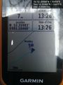
Several approaches were tried. The final and closest approach got to 7 or 8 metres away but the hashpoint was on the wrong side of a dense hedge. Foiled!
Photos
Foiled. @52.3598,1.1045
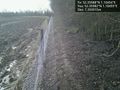
Rabbit fence. @52.3598,1.1045
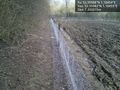
Rabbit fence. @52.3598,1.1045
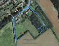
Google Earth Track


Achievements
Expeditions and Plans
| 2016-03-07 | ||
|---|---|---|
| Canberra, Australia | 1PE | Beside a road and a storm water drain, near the Embassy of Jordan, in Canbe... |
| Norwich, United Kingdom | Sourcerer | A field edge at Palgrave south of Diss, just over the border in Suffolk, UK... |
| Kiel, Germany | ZettS | Sports ground of the Ernst-Barlach-Gymnaium Kiel (academic high school) |
Sourcerer's Expedition Links
2016-03-01 52 1 - 2016-03-07 52 1 - 2016-03-14 51 0 - KML file download of Sourcerer's expeditions for use with Google Earth.