2016-03-01 52 1
| Tue 1 Mar 2016 in Norwich, UK: 52.4280396, 1.3775138 geohashing.info google osm bing/os kml crox |
Location
A sand quarry west of Bungay, Suffolk, UK. This is 5 km from home.
Participants
Plans
A footpath runs past this quarry. From memory, there were few if any fences or gates and the the hashpoint looks as though it's on dry land. Of course it might have been dredged out and turned into a lake since Google took their image.
Expedition
Elaborate metal gates blocked the main access track. After driving a circular route looking for a better approach, there was an alternative footpath bypassing the closed and locked gates. This led to the planned track and right of way. Later in the walk, without gates or fences or even signs, I passed a large JCB digger. A muddy but passable track led towards the hashpoint. Right at the end, there were large, uneven heaps of dumped concrete and various piles of discarded tube and wire to negotiate. The final approach was on level ground with hundreds of bags, stacked on pallets. They contained an unknown material related to quarrying. My phone lost GPS lock and said I was about 12 metres away. My Garmin receiver said I was within 1 metre.
Photos
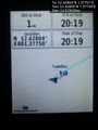
Arrival proof. @52.4281,1.3773
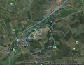
Google Earth Track
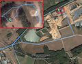
Google Earth Overview


Achievements
Expeditions and Plans
| 2016-03-01 | ||
|---|---|---|
| Mannheim, Germany | DODO | A field next to Limburgerhof. |
| Norwich, United Kingdom | Sourcerer | A sand quarry west of Bungay, Suffolk, UK. This is 5 km from home. |
| Närpiö, Finland | thestormer | A clearcutting/young forest in the village of Böle in Närpes |
Sourcerer's Expedition Links
2016-02-27 52 0 - 2016-03-01 52 1 - 2016-03-07 52 1 - KML file download of Sourcerer's expeditions for use with Google Earth.