Difference between revisions of "2016-03-17 52 1"
From Geohashing
imported>Sourcerer (An expedition message sent via Geohash Droid for Android.) |
imported>FippeBot m (Location) |
||
| (4 intermediate revisions by one other user not shown) | |||
| Line 1: | Line 1: | ||
| − | + | {{meetup graticule | |
| − | |||
| − | |||
| − | |||
| − | |||
| − | |||
| − | |||
| − | |||
| − | |||
| − | |||
| − | {{meetup graticule | ||
| lat=52 | | lat=52 | ||
| lon=1 | | lon=1 | ||
| date=2016-03-17 | | date=2016-03-17 | ||
| + | | graticule_name=Norwich, UK | ||
| + | | graticule_link=Norwich, United Kingdom | ||
}} | }} | ||
| + | __NOTOC__ | ||
| + | == Location == | ||
| − | + | A meadow on common land at Thornage, Norfolk, UK. | |
| − | |||
| − | == | + | == Participants == |
| − | |||
| − | + | [[User:Sourcerer|Sourcerer]] | |
| − | |||
| − | |||
== Plans == | == Plans == | ||
| − | + | ||
| + | Expedition one of two spanning midnight - [[2016-03-17 52 1]] - [[2016-03-18 52 1]] - ETA 23:05. | ||
== Expedition == | == Expedition == | ||
| − | |||
| − | + | The weather was ideal for an expedition with dry conditions and moonlight but there was some cloud. The hashpoint was on common land and the terrain was grassy meadow. There was a sandy lay-by to park close to the destination so it was all very easy. | |
| − | |||
== Photos == | == Photos == | ||
| − | + | ||
| − | |||
| − | |||
<gallery perrow="5"> | <gallery perrow="5"> | ||
| + | Image:2016-03-17_52_1_Sourcerer_1458253612327.jpg | Arrival. [http://www.openstreetmap.org/?lat=52.88146734&lon=1.04252100&zoom=16&layers=B000FTF @52.8815,1.0425] | ||
| + | Image:2016-03-17 52 1 Sourcerer.jpg | Google Earth Track | ||
</gallery> | </gallery> | ||
== Achievements == | == Achievements == | ||
{{#vardefine:ribbonwidth|800px}} | {{#vardefine:ribbonwidth|800px}} | ||
| − | |||
| − | + | {{Last man standing | |
| − | + | | latitude = 52 | |
| − | + | | longitude = 1 | |
| + | | date = 2016-03-17 | ||
| + | | gender = man | ||
| + | | name = Sourcerer | ||
| + | }} | ||
| − | + | {{Sourcerer_links | |
| − | + | | prev = 2016-03-15 51 0 | |
| − | + | | curr = 2016-03-17 52 1 | |
| − | -- | + | | next = 2016-03-18 52 1 |
| − | + | | date = 2016-03-17 | |
| − | + | }} | |
| − | |||
[[Category:Expeditions]] | [[Category:Expeditions]] | ||
| − | |||
[[Category:Expeditions with photos]] | [[Category:Expeditions with photos]] | ||
| − | |||
| − | |||
| − | |||
| − | |||
| − | |||
[[Category:Coordinates reached]] | [[Category:Coordinates reached]] | ||
| − | + | {{location|GB|ENG|NFK}} | |
| − | |||
| − | |||
| − | |||
| − | |||
| − | |||
| − | |||
| − | |||
| − | |||
| − | |||
| − | |||
| − | |||
| − | |||
| − | |||
| − | |||
| − | |||
| − | |||
| − | |||
Latest revision as of 06:56, 15 August 2019
| Thu 17 Mar 2016 in Norwich, UK: 52.8814969, 1.0425514 geohashing.info google osm bing/os kml crox |
Location
A meadow on common land at Thornage, Norfolk, UK.
Participants
Plans
Expedition one of two spanning midnight - 2016-03-17 52 1 - 2016-03-18 52 1 - ETA 23:05.
Expedition
The weather was ideal for an expedition with dry conditions and moonlight but there was some cloud. The hashpoint was on common land and the terrain was grassy meadow. There was a sandy lay-by to park close to the destination so it was all very easy.
Photos
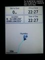
Arrival. @52.8815,1.0425
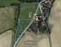
Google Earth Track


Achievements
Sourcerer earned the Last man standing achievement
|
Expeditions and Plans
| 2016-03-17 | ||
|---|---|---|
| Norwich, United Kingdom | Sourcerer | A meadow on common land at Thornage, Norfolk, UK. |
Sourcerer's Expedition Links
2016-03-15 51 0 - 2016-03-17 52 1 - 2016-03-18 52 1 - KML file download of Sourcerer's expeditions for use with Google Earth.