Difference between revisions of "2016-03-23 52 1"
From Geohashing
imported>Sourcerer m (→New expedition) |
m |
||
| (7 intermediate revisions by 2 users not shown) | |||
| Line 15: | Line 15: | ||
[[User:Sourcerer|Sourcerer]] | [[User:Sourcerer|Sourcerer]] | ||
| − | == Expedition == | + | == Expedition - Fail == |
*Foiled. -- [[User:Sourcerer|Sourcerer]] ([[User talk:Sourcerer|talk]]) [http://www.openstreetmap.org/?lat=52.54756987&lon=1.39978588&zoom=16&layers=B000FTF @52.5476,1.3998] 15:16, 23 March 2016 (GMT) | *Foiled. -- [[User:Sourcerer|Sourcerer]] ([[User talk:Sourcerer|talk]]) [http://www.openstreetmap.org/?lat=52.54756987&lon=1.39978588&zoom=16&layers=B000FTF @52.5476,1.3998] 15:16, 23 March 2016 (GMT) | ||
| Line 21: | Line 21: | ||
This was a domain of horses and could not be accessed. These low lying watery hashpoints are a problem in this area. | This was a domain of horses and could not be accessed. These low lying watery hashpoints are a problem in this area. | ||
| − | == Photos == | + | == Photos == |
| − | + | <gallery perrow=4> | |
| − | <gallery perrow= | + | Image:2016-03-23 52 1 Sourcerer.jpg | Horses, Fences, Foiled! |
| − | Image: | ||
</gallery> | </gallery> | ||
| Line 33: | Line 32: | ||
| prev = 2016-03-19 52 1 | | prev = 2016-03-19 52 1 | ||
| curr = 2016-03-23 52 1 | | curr = 2016-03-23 52 1 | ||
| − | | next = 2016-03- | + | | next = 2016-03-27 51 0 |
| date = 2016-03-23 | | date = 2016-03-23 | ||
}} | }} | ||
| Line 40: | Line 39: | ||
[[Category:Expeditions with photos]] | [[Category:Expeditions with photos]] | ||
[[Category:Coordinates not reached]] | [[Category:Coordinates not reached]] | ||
| + | [[Category:Not reached - No public access]] | ||
| + | {{location|GB|ENG|NFK}} | ||
Latest revision as of 11:51, 27 March 2022
| Wed 23 Mar 2016 in Norwich, UK: 52.5465434, 1.4002527 geohashing.info google osm bing/os kml crox |
Location
A meadow close to the source of the river Chet, Norfolk, UK.
Participants
Expedition - Fail
- Foiled. -- Sourcerer (talk) @52.5476,1.3998 15:16, 23 March 2016 (GMT)
This was a domain of horses and could not be accessed. These low lying watery hashpoints are a problem in this area.
Photos
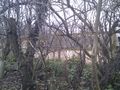
Horses, Fences, Foiled!

Achievements
Expeditions and Plans
| 2016-03-23 | ||
|---|---|---|
| Mannheim, Germany | Q-Owl | On the BASF area near Frankenthal. |
| Kassel, Germany | GeorgDerReisende | The hash lay in Hümme on the side of the former railway track of the Carlsb... |
| Norwich, United Kingdom | Sourcerer | A meadow close to the source of the river Chet, Norfolk, UK. |
Sourcerer's Expedition Links
2016-03-19 52 1 - 2016-03-23 52 1 - 2016-03-27 51 0 - KML file download of Sourcerer's expeditions for use with Google Earth.