Difference between revisions of "2016-03-27 42 -85"
imported>Mcbaneg (Created page with "<!-- If you did not specify these parameters in the template, please substitute appropriate values for IMAGE, LAT, LON, and DATE (YYYY-MM-DD format) {{{image|2016-03-27 42...") |
imported>FippeBot m (Location) |
||
| (One intermediate revision by one other user not shown) | |||
| Line 30: | Line 30: | ||
== Expedition == | == Expedition == | ||
| − | On the highway, in the right-hand lane. We had visited friends for an Easter meal and made a brief detour on the way home to pick this one up. Susanne drove, Rebekah sat in back seat with camera to demonstrate cruising speed, and George rode shotgun doing repeated screenshots to demonstrate progress. We got on the highway near our friends' house, drove west (actually north along this stretch of highway) past the hashpoint to the next interchange, exited and re-entered eastbound, and cruised through the hashpoint in the right lane. Judging from the satmap George and Rebekah, on the right side of the car, probably passed right through the hashpoint. | + | On the highway, in the right-hand lane. We had visited friends for an Easter meal and made a brief detour on the way home to pick this one up. Susanne drove, Rebekah sat in the back seat with camera to demonstrate cruising speed, and George rode shotgun doing repeated screenshots to demonstrate progress. We got on the highway near our friends' house, drove west (actually north along this stretch of highway) past the hashpoint to the next interchange, exited and re-entered eastbound, and cruised through the hashpoint in the right lane. Judging from the satmap George and Rebekah, on the right side of the car, probably passed right through the hashpoint. |
== Photos == | == Photos == | ||
| Line 74: | Line 74: | ||
[[Category:Expeditions with photos]] | [[Category:Expeditions with photos]] | ||
[[Category:Coordinates reached]] | [[Category:Coordinates reached]] | ||
| + | {{location|US|MI|KN}} | ||
Latest revision as of 00:02, 16 August 2019
| Sun 27 Mar 2016 in 42,-85: 42.9946308, -85.6050404 geohashing.info google osm bing/os kml crox |
Location
Right eastbound lane of I-96 between Knapp and Leonard streets, Grand Rapids, MI
Participants
Expedition
On the highway, in the right-hand lane. We had visited friends for an Easter meal and made a brief detour on the way home to pick this one up. Susanne drove, Rebekah sat in the back seat with camera to demonstrate cruising speed, and George rode shotgun doing repeated screenshots to demonstrate progress. We got on the highway near our friends' house, drove west (actually north along this stretch of highway) past the hashpoint to the next interchange, exited and re-entered eastbound, and cruised through the hashpoint in the right lane. Judging from the satmap George and Rebekah, on the right side of the car, probably passed right through the hashpoint.
Photos
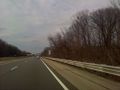
Speed limit sign, actually on westbound side of road (but the eastbound limit is the same.)
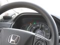
Speedometer shot by Rebekah, taken as hashpoint was being approached.
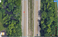
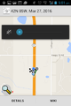
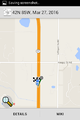
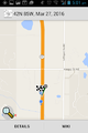
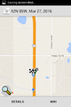
Satmap showing location of hashpoint on road.
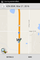
First of several screenshots. I suggest printing them out and making a flip-book.

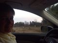
Susanne at wheel.
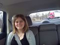
Rebekah wishing she was at home doing her homework rather than riding pointlessly around town.


Achievements

George earned the Consecutive geohash achievement
|