Difference between revisions of "2016-03-27 48 8"
imported>DODO (→Achievements) |
m (Location correction) |
||
| (2 intermediate revisions by 2 users not shown) | |||
| Line 45: | Line 45: | ||
Image:2012-##-## ## ## Alpha.jpg | Witty Comment | Image:2012-##-## ## ## Alpha.jpg | Witty Comment | ||
--> | --> | ||
| − | <gallery perrow=" | + | <gallery perrow="4"> |
| + | Image:2016-03-27_48_8-1.jpg|view to the golf course | ||
| + | Image:2016-03-27_48_8-2.jpg|proof of transport | ||
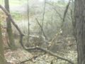
| + | Image:2016-03-27_48_8-3.jpg|the path | ||
| + | Image:2016-03-27_48_8-8.png|proof | ||
| + | Image:2016-03-27_48_8-4.jpg|view from the hash through the thicket to the path and the golf course | ||
| + | Image:2016-03-27_48_8-5.jpg|in the other direction it is just forest | ||
| + | Image:2016-03-27_48_8-6.jpg|happy hasher with silly grin | ||
| + | Image:2016-03-27_48_8-7.jpg|kind of x | ||
</gallery> | </gallery> | ||
| − | |||
== Achievements == | == Achievements == | ||
| Line 61: | Line 68: | ||
[[Category:Expeditions]] | [[Category:Expeditions]] | ||
[[Category:Coordinates reached]] | [[Category:Coordinates reached]] | ||
| + | {{location|DE|BW|KA}} | ||
Latest revision as of 20:32, 16 May 2020
| Sun 27 Mar 2016 in 48,8: 48.9946308, 8.6050404 geohashing.info google osm bing/os kml crox |
Location
A forest next to a golf course near Wösslingen.
Participants
Plans
Go there by bull, continue my ride to Karlsruhe and come back by train.
Expedition
Pretty much as planned. I couldn't start before 1 pm and I wanted to catch the 16:08-train from Karlsruhe (the train goes every two hours and the next train would have been much to late). I had to go 70 kilometers and so I had to hurry. That was a pity, as I love the landscape of the Kraichgau very much but hadn't much time to enjoy it. Anyway. I came near the hash after 50 kilometers at five to three. I found myself on a path between a golf course on my right hand and a forest, that was protected by a nearly impenetrable thicket on my left hand. On the path I came down to 7 m, but that wasn't enough. So I followed the path to find a way inside the forest, and after 20 m the thicket had an outlet, just big enough for me. So I entered the forest and walked back. A minute later I found myself at the hash, took some pictures, build a wooden X and walked back to the outlet.
10 minutes after I parked it, I unleashed the bull again and continued my way. Soon I reached the suburbs of Karlsruhe and I reached the station at 15:50. Time enough to buy a ticket and some food, and to heave the heavy bull into the train. So I arrived back home at 5 pm.
Tracklog
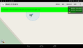
70KM of bull-riding. As I ran out of batteries, I couldn't track the train-ride.
Photos
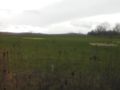
view to the golf course
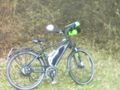
proof of transport
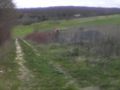
the path
proof
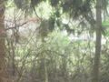
view from the hash through the thicket to the path and the golf course
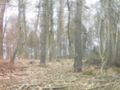
in the other direction it is just forest

happy hasher with silly grin
kind of x


Achievements
DODO earned the Land geohash achievement
|