Difference between revisions of "2016-03-30 48 9"
imported>Drei aus Korb (Heute war's endlich soweit : Die Entfernung machbar, die Location potentiell interessant und erreichbar und wir hatten Zeit. Trotz Regenwetter sind wir los und UNSER ERSTER HASH! [http://www.openstreetmap.org/?lat=48.84115390&lon=9.35886950&zoom=16&lay...) |
m (Category) |
||
| (17 intermediate revisions by 3 users not shown) | |||
| Line 1: | Line 1: | ||
| − | Heute war's endlich soweit: zwei von drei hatten Zeit, die Koordinaten waren in der Nähe, das Ziel potentiell interessant und erreichbar. Also trotz Regenwetter rein in's und los. Wir | + | |
| − | Ein Kunstwerk hinterlassen, ein paar Fotos geschossen und | + | <!-- If you did not specify these parameters in the template, please substitute appropriate values for IMAGE, LAT, LON, and DATE (YYYY-MM-DD format) |
| − | <gallery> | + | |
| − | Image:2016-03-30_48_9_Drei aus Korb _1459344675873.jpg| | + | [[Image:{{{image|IMAGE}}}|thumb|left]] |
| − | + | ||
| − | + | Remove this section if you don't want an image at the top (left) of your report. You should remove the "Image:" or "File:" | |
| + | tag from your image file name, and replace the all upper-case word IMAGE in the above line. | ||
| + | |||
| + | And DON'T FORGET to add your expedition and the best photo you took to the gallery on the Main Page! We'd love to read your report, but that means we first have to discover it! :) | ||
| + | --> | ||
| + | {{meetup graticule | ||
| + | | lat=48 | ||
| + | | lon=9 | ||
| + | | date=2016-03-30 | ||
| + | }} | ||
| + | |||
| + | <!-- edit as necessary --> | ||
| + | __NOTOC__ | ||
| + | |||
| + | == Location == | ||
| + | <!-- where you've surveyed the hash to be --> | ||
| + | Ein Wald bei Allmersbach im Tal, Germany | ||
| + | |||
| + | == Participants == | ||
| + | <!-- who attended: If you link to your wiki user name in this section, your expedition will be picked up by the various statistics generated for geohashing. You may use three tildes ~ as a shortcut to automatically insert the user signature of the account you are editing with. | ||
| + | --> | ||
| + | Mara & Holger / [[User:Drei aus Korb|Drei aus Korb]] | ||
| + | |||
| + | == Plans == | ||
| + | <!-- what were the original plans --> | ||
| + | Endlich ein passender Hash: Nix wie hin! | ||
| + | |||
| + | == Expedition == | ||
| + | Heute war's endlich soweit: zwei von drei hatten Zeit, die Koordinaten waren in der Nähe, das Ziel potentiell interessant und erreichbar. Also trotz Regenwetter rein in's Auto und los. Wir konnten in der Nähe parken und fanden sogar im Wald einen Pfad, der uns in die Nähe des Ziels führte. Und Hooray: UNSER ERSTER HASH! | ||
| + | Ein Kunstwerk hinterlassen, ein paar Fotos geschossen und patschnass aber zufrieden zurück zum Auto und nix wie Heim. | ||
| + | |||
| + | Anmerkung: am Ziel hat irgendwie der Geohash Droid nicht so wollen wie wir, könnte möglicherweise eventuell vielleicht auch ein Bedienerfehler gewesen sein ;-), auf jeden Fall hat der sich irgendie fast schon zu Hause mit dem Wiki verbunden: der aufmerksame Beobachter merkt sofort, dass im Bild eine Distanz von 9,107336 km zu Ziel angezeigt wird. Deshalb auch der Screenshot, der beweist, dass wir tatsächlich vor Ort waren. | ||
| + | |||
| + | |||
| + | Short summary in English: | ||
| + | |||
| + | Our first geohash ever led us deep into a forest at Almersbach im Tal near Backnang on a rainy day. | ||
| + | Unfortunately the Geohash Droid didn't send the photo to the wiki unless we were nearly back home; so the stamp shows 9,107336 km distance from target. | ||
| + | Well, at least the screenshot proves we were there! | ||
| + | |||
| + | == Photos == | ||
| + | <!-- Insert pictures between the gallery tags using the following format: | ||
| + | Image:2012-##-## ## ## Alpha.jpg | Witty Comment | ||
| + | --> | ||
| + | <gallery perrow="4"> | ||
| + | Image:2016-03-30_48_9_Drei aus Korb _1459344675873.jpg|Kunst am Ziel | ||
| + | Image:Screenshot_2016-03-30-12-23-04.png|Droid Screenshot | ||
| + | Image:Einweg.JPG|A path... | ||
| + | Image:Hierlang.JPG|...hooray, this way! | ||
| + | Image:Kunstamziel.JPG|Kunst am Ziel | ||
</gallery> | </gallery> | ||
| + | |||
| + | [[Category:Expeditions]] | ||
| + | [[Category:Coordinates reached]] | ||
| + | |||
| + | == Achievements == | ||
| + | {{#vardefine:ribbonwidth|800px}} | ||
| + | <!-- Add any achievement ribbons you earned below, or remove this section --> | ||
| + | == Achievements == | ||
| + | {{#vardefine:ribbonwidth|800px}} | ||
| + | |||
| + | {{land geohash | ||
| + | | latitude = 48 | ||
| + | | longitude = 9 | ||
| + | | date = 2016-03-30 | ||
| + | | name = Drei aus Korb | ||
| + | }} | ||
| + | [[Category:Expeditions]] | ||
| + | [[Category:Coordinates reached]] | ||
| + | [[Category:Pages in German]] | ||
| + | {{location|DE|BW|BK}} | ||
Latest revision as of 12:19, 10 January 2022
| Wed 30 Mar 2016 in 48,9: 48.8954719, 9.4517729 geohashing.info google osm bing/os kml crox |
Location
Ein Wald bei Allmersbach im Tal, Germany
Participants
Mara & Holger / Drei aus Korb
Plans
Endlich ein passender Hash: Nix wie hin!
Expedition
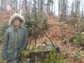
Heute war's endlich soweit: zwei von drei hatten Zeit, die Koordinaten waren in der Nähe, das Ziel potentiell interessant und erreichbar. Also trotz Regenwetter rein in's Auto und los. Wir konnten in der Nähe parken und fanden sogar im Wald einen Pfad, der uns in die Nähe des Ziels führte. Und Hooray: UNSER ERSTER HASH! Ein Kunstwerk hinterlassen, ein paar Fotos geschossen und patschnass aber zufrieden zurück zum Auto und nix wie Heim.
Anmerkung: am Ziel hat irgendwie der Geohash Droid nicht so wollen wie wir, könnte möglicherweise eventuell vielleicht auch ein Bedienerfehler gewesen sein ;-), auf jeden Fall hat der sich irgendie fast schon zu Hause mit dem Wiki verbunden: der aufmerksame Beobachter merkt sofort, dass im Bild eine Distanz von 9,107336 km zu Ziel angezeigt wird. Deshalb auch der Screenshot, der beweist, dass wir tatsächlich vor Ort waren.
Short summary in English:
Our first geohash ever led us deep into a forest at Almersbach im Tal near Backnang on a rainy day. Unfortunately the Geohash Droid didn't send the photo to the wiki unless we were nearly back home; so the stamp shows 9,107336 km distance from target. Well, at least the screenshot proves we were there!
Photos
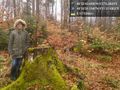
Kunst am Ziel
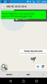
Droid Screenshot
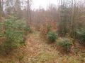
A path...
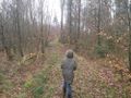
...hooray, this way!
Kunst am Ziel


Achievements
Achievements
Drei aus Korb earned the Land geohash achievement
|