Difference between revisions of "2016-03-31 49 8"
imported>DODO (Created page with "{{subst:Expedition|lat=49|lon=8|date=2016-03-31}}") |
imported>FippeBot m (Location) |
||
| (18 intermediate revisions by 2 users not shown) | |||
| Line 1: | Line 1: | ||
| − | + | <!-- | |
| − | <!-- | ||
| − | |||
[[Image:{{{image|IMAGE}}}|thumb|left]] | [[Image:{{{image|IMAGE}}}|thumb|left]] | ||
| − | |||
| − | |||
| − | |||
| − | |||
| − | |||
--> | --> | ||
{{meetup graticule | {{meetup graticule | ||
| Line 19: | Line 12: | ||
== Location == | == Location == | ||
| − | + | Near Darmstadt-Eberstadt next to the B426 highway. | |
== Participants == | == Participants == | ||
| − | + | ||
| − | + | *[[User:DODO|DODO]] | |
| + | *[[User:Q-Owla|Q-Owla]] | ||
| + | *[[User:Q-Owl|Q-Owl]] | ||
| + | |||
| + | == Plans == | ||
| + | |||
| + | '''DODO:''' Another hash in the Rhine Valley but we're getting closer to the edge. And it is close enough to today's hash, so I can walk there without usig a train, and that's just what I Plan to do. | ||
| + | |||
| + | It's a 25 kilometers walk and I hope to arrive around 4. | ||
| − | + | '''Q-Owla and Q-Owl:''' We planned to find some geocaches and noticed, that todays gh was not far from us. And it did not lie on the military area but between it and the B426. | |
| − | + | So we decided to go for it. | |
== Expedition == | == Expedition == | ||
| − | <!-- | + | |
| + | ===Q-Owla and Q-Owl=== | ||
| + | We drove near the hashpoint and had a little bit to dance (under clouds and trees) until we got near enough to it. We waited a while if Dodo might arrive and this time we left a mark for him. | ||
| + | <br>Sorry, that we did not meet each other. But you are invited for a cup of coffee, lunch or what ever you like at our home. | ||
| + | |||
| + | Later we found about 10 geocaches ([http://www.geaocaching.com/ www.geaocaching.com] and [http://www.opencaching.de/ www.opencaching.de]) near Ober-Ramstadt. | ||
| + | |||
| + | |||
| + | ===DODO=== | ||
| + | This is part four of this years hash-tour. Here you find the parts [[2016-03-30_49_8|three]] and [[2016-04-01_49_8|five]]. | ||
| + | |||
| + | The hash god was nice to me. It was still another point in the rhine valley, and I didn't get any mountains, but at least todays hash was close enough to the one yesterday, that I could walk all the way again. | ||
| + | |||
| + | Todays walk seemed to have some recurrent themes: paths and streets, live and death, freedom and imprissonment. | ||
| + | {| | ||
| + | |- | ||
| + | ! style="width:300px" | !! style="width:300px" | !! style="width:300px" | | ||
| + | |- | ||
| + | | [[Image:2016-03-31 49 8-1.jpg | 300px]] ||Just when I've left Groß-Gerau I had to cross the autobahn. After that I followed it for a while. Yes, the small green strip next to the asphalt is my path. | ||
| + | |- | ||
| + | |} | ||
| + | |||
| + | I had to cross an Autobahn for five more times today: | ||
| + | {| | ||
| + | |- | ||
| + | ! style="width:200px" | !! style="width:200px" | !! style="width:200px" | !! style="width:200px" | !! style="width:200px" | | ||
| + | |- | ||
| + | |[[Image:2016-03-31 49 8-9.jpg| 200px]] ||[[Image:2016-03-31 49 8-10.jpg | 200px]] ||[[Image:2016-03-31 49 8-13.jpg| 200px]] ||[[Image:2016-03-31 49 8-18.jpg| 200px]] ||[[Image:2016-03-31 49 8-24.jpg | 200px]] | ||
| + | |- | ||
| + | | In the middle of the forest between Griesheim and Darmstadt||On a road before I reached Tann||South of Darmstadt near the Heimstätten-Siedlung||To get from Pfungstadt to Eberstadt and the hash|| To get back from the hash to Pfungstadt. | ||
| + | |- | ||
| + | |} | ||
| + | |||
| + | {| | ||
| + | |- | ||
| + | ! style="width:300px" | !! style="width:300px" | !! style="width:300px" | | ||
| + | |- | ||
| + | | [[Image:2016-03-31 49 8-2.jpg | 300px]] ||[[Image:2016-03-31 49 8-3.jpg | 300px]] ||But first I had to walk through some fields and I photographed my first animals for today, some wild geese. A short time later I reached the forest (that I will almost only leave to cross an Autobahn). | ||
| + | |- | ||
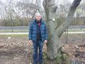
| + | | [[Image:2016-03-31 49 8-7.jpg | 300px]] ||[[Image:2016-03-31 49 8-8.jpg | 300px]] || Some more paths and a special tree with a name | ||
| + | |- | ||
| + | | [[Image:2016-03-31 49 8-4.jpg | 300px]] ||[[Image:2016-03-31 49 8-5.jpg | 300px]] || Then I came along some prisons. One for people and one - strange enough - for a dromedary. | ||
| + | |- | ||
| + | || Traces of a free animal || working animals (bees) || and a free - but death - animal | ||
| + | |- | ||
| + | | [[Image:2016-03-31 49 8-14.jpg | 300px]] ||[[Image:2016-03-31 49 8-11.jpg | 300px]] ||[[Image:2016-03-31 49 8-15.jpg | 300px]] | ||
| + | |- | ||
| + | | [[Image:2016-03-31 49 8-16.jpg | 300px]] ||[[Image:2016-03-31 49 8-17.jpg | 300px]] || I don't know if this is another prison or a military are, but on the second picture you see the remaining of the gibbet of Pfungstadt | ||
| + | |- | ||
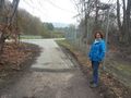
| + | | [[Image:2016-03-31 49 8-29.png | 300px]] ||[[Image:2016-03-31 49 8-20.jpg | 300px]] ||Finally I reached the hash next to this busy road. | ||
| + | |- | ||
| + | | [[Image:2016-03-31 49 8-23.jpg | 300px]] ||[[Image:2016-03-31 49 8-22.jpg | 300px]] || I found the Owl's mark and left my own. | ||
| + | |- | ||
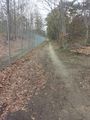
| + | | [[Image:2016-03-31 49 8-21.jpg | 300px]] ||[[Image:2016-03-31 49 8-grin.jpg | 300px]] || I'm on the outside of this fence. A soldier came along on the inside but didn't take care of me. | ||
| + | |- | ||
| + | | [[Image:2016-03-31 49 8-25.jpg | 300px]] ||[[Image:2016-03-31 49 8-26.jpg | 300px]] || I made a little detour in Pfungstadt to see the Villa Büchner, but it isn't the house of the famous romantic author but of a local entrepreneur. A short time later I came along this former mill. | ||
| + | |- | ||
| + | | [[Image:2016-03-31 49 8-27.jpg | 300px]] ||[[Image:2016-03-31 49 8-28.jpg | 300px]] || And Pfundstadt proofs humor: a fountain called entrance for the major. A short smile later I arrived at the hotel. | ||
| + | |- | ||
| + | |} | ||
== Tracklog == | == Tracklog == | ||
| − | + | [https://www.komoot.de/tour/8325712 29 KM walking] | |
== Photos == | == Photos == | ||
| − | + | ||
| − | + | ===Q-Owla and Q-Owl=== | |
| − | -- | ||
<gallery perrow="5"> | <gallery perrow="5"> | ||
| + | Image:2016-03-31 49 8 hp.jpg | Marked hashpoint and view north | ||
| + | Image:2016-03-31 49 8 proof.png | Proof 0.37 m | ||
| + | Image:2016-03-31 49 8 w.jpg | View west | ||
| + | Image:2016-03-31 49 8 e.jpg | View east | ||
</gallery> | </gallery> | ||
== Achievements == | == Achievements == | ||
| − | {{#vardefine:ribbonwidth| | + | {{#vardefine:ribbonwidth|900px}}{{land geohash |
| − | + | | latitude = 49 | |
| + | | longitude = 8 | ||
| + | | date = 2016-03-31 | ||
| + | | name = DODO, Q-Owla, Q-Owl | ||
| + | }} | ||
| + | {{gratuitous ribbon | ||
| + | | icon = Avoid achievement.png | ||
| + | | latitude = 49 | ||
| + | | longitude = 8 | ||
| + | | date = 2016-03-31 | ||
| + | | achievement = Avoid Each Other Achievement | ||
| + | | description = launching two independent expeditions without meeting up at the | ||
| + | | name = DODO, Q-Owla, Q-Owl | ||
| + | }} | ||
| − | |||
| − | |||
| − | |||
| − | + | {{consecutive geohash | |
| − | + | | count = 5 | |
| − | [[ | + | | latitude = 48 |
| − | -- | + | | longitude = 8 |
| + | | date = 2016-03-27 | ||
| + | | name = [[User:DODO|DODO]] | ||
| + | }} | ||
| + | {{Walk geohash | ||
| + | | latitude = 49 | ||
| + | | longitude = 8 | ||
| + | | date = 2016-03-31 | ||
| + | | name = DODO | ||
| + | | distance = 29 KM | ||
| + | }} | ||
| − | |||
| − | + | {{Radio Yerevan | |
| − | + | | achievement = Hash collision | |
| − | + | | detail = the cache GC2MEX4 under the bridge nearby wasn't there today and found by me already one year ago | |
| − | + | | date = 2016-03-31 | |
| − | + | | latitude = 49 | |
| − | [[ | + | | longitude = 8 |
| − | + | | user = [[User:Q-Owl |Q-Owl ]] | |
| − | + | }} | |
| − | |||
| − | |||
| + | == Other Geohashing Expeditions and Plans on this Day == | ||
| − | -- | + | {{expedition summaries|2016-03-28}} |
| − | |||
| − | |||
| − | |||
| − | |||
| − | |||
| − | |||
| − | |||
| − | + | [[Category:Expeditions]] | |
| − | [[Category: | + | [[Category:Coordinates reached]] |
| − | + | [[Category:Expeditions with photos]] | |
| − | |||
| − | [[Category: | ||
| − | + | [[Category: Meetup on 2016-03-31]] | |
| + | [[Category: Meetup in 49 8]] | ||
| + | {{location|DE|HE|DA|city=true}} | ||
Latest revision as of 00:04, 16 August 2019
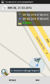
| Thu 31 Mar 2016 in 49,8: 49.8040197, 8.6340738 geohashing.info google osm bing/os kml crox |
Location
Near Darmstadt-Eberstadt next to the B426 highway.
Participants
Plans
DODO: Another hash in the Rhine Valley but we're getting closer to the edge. And it is close enough to today's hash, so I can walk there without usig a train, and that's just what I Plan to do.
It's a 25 kilometers walk and I hope to arrive around 4.
Q-Owla and Q-Owl: We planned to find some geocaches and noticed, that todays gh was not far from us. And it did not lie on the military area but between it and the B426. So we decided to go for it.
Expedition
Q-Owla and Q-Owl
We drove near the hashpoint and had a little bit to dance (under clouds and trees) until we got near enough to it. We waited a while if Dodo might arrive and this time we left a mark for him.
Sorry, that we did not meet each other. But you are invited for a cup of coffee, lunch or what ever you like at our home.
Later we found about 10 geocaches (www.geaocaching.com and www.opencaching.de) near Ober-Ramstadt.
DODO
This is part four of this years hash-tour. Here you find the parts three and five.
The hash god was nice to me. It was still another point in the rhine valley, and I didn't get any mountains, but at least todays hash was close enough to the one yesterday, that I could walk all the way again.
Todays walk seemed to have some recurrent themes: paths and streets, live and death, freedom and imprissonment.
 |
Just when I've left Groß-Gerau I had to cross the autobahn. After that I followed it for a while. Yes, the small green strip next to the asphalt is my path. |
I had to cross an Autobahn for five more times today:
 |
 |
 |
 |

|
| In the middle of the forest between Griesheim and Darmstadt | On a road before I reached Tann | South of Darmstadt near the Heimstätten-Siedlung | To get from Pfungstadt to Eberstadt and the hash | To get back from the hash to Pfungstadt. |
 |
 |
But first I had to walk through some fields and I photographed my first animals for today, some wild geese. A short time later I reached the forest (that I will almost only leave to cross an Autobahn). |
 |
 |
Some more paths and a special tree with a name |
 |
 |
Then I came along some prisons. One for people and one - strange enough - for a dromedary. |
| Traces of a free animal | working animals (bees) | and a free - but death - animal |
 |
 |

|
 |
 |
I don't know if this is another prison or a military are, but on the second picture you see the remaining of the gibbet of Pfungstadt |
 |
 |
Finally I reached the hash next to this busy road. |
 |
 |
I found the Owl's mark and left my own. |
 |
 |
I'm on the outside of this fence. A soldier came along on the inside but didn't take care of me. |
 |
 |
I made a little detour in Pfungstadt to see the Villa Büchner, but it isn't the house of the famous romantic author but of a local entrepreneur. A short time later I came along this former mill. |
 |
 |
And Pfundstadt proofs humor: a fountain called entrance for the major. A short smile later I arrived at the hotel. |
Tracklog
Photos
Q-Owla and Q-Owl
Marked hashpoint and view north
Proof 0.37 m
View west
View east


Achievements
DODO, Q-Owla, Q-Owl earned the Land geohash achievement
|
DODO, Q-Owla, Q-Owl earned the Avoid Each Other Achievement
|
DODO earned the Consecutive geohash achievement
|
DODO earned the Walk geohash Achievement
|
Is it true that Q-Owl earned the Hash collision?
|
Other Geohashing Expeditions and Plans on this Day
Expeditions and Plans
| 2016-03-28 | ||
|---|---|---|
| Mannheim, Germany | DODO, Q-Owla, Q-Owl | A field near Stockstadt am Rhein. |
| Norwich, United Kingdom | ChromeCrusaders, Sourcerer | A patch of public land very close to a patch of private land, East Ruston, ... |