2016-04-01 49 8
From Geohashing
Revision as of 20:14, 1 April 2016 by imported>Q-Owl (Created page with "thumb|left|xxx xxx {{meetup graticule | lat=49 | lon=8 | date=2016-04-01 }}__NOTOC__ == Location == A hashpoint near wikipedia:Grünstadt|...")
File:2016-04-01 49 8 d.jpg
xxx xxx
| Fri 1 Apr 2016 in 49,8: 49.5822653, 8.1592834 geohashing.info google osm bing/os kml crox |
Location
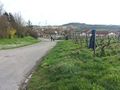
A hashpoint near Grünstadt on the left side of the Rhine valley.
Participants
Plan
Drive near the hashpoint, find it, walk back to the car, find some geocaches and drive home.
Expedition
Success! :-)
Photos
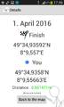
Proof
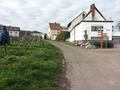
View W
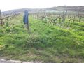
View N with my jacket at the hp
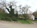
View E
View S

Grin


Achievements
Q-Owl earned the Land geohash achievement
|
Q-Owl earned the Consecutive geohash achievement
|
Other Geohashing Expeditions and Plans on this Day
Expeditions and Plans
| 2016-04-01 | ||
|---|---|---|
| Mannheim, Germany | Q-Owl, DODO | A hashpoint near Grünstadt on the left side of the Rhine valley. |
| Norwich, United Kingdom | Sourcerer | A field near Kett's Oak, Norfolk, UK. |