Difference between revisions of "2016-04-02 47 -122"
imported>Thomcat ([live picture]Dragonfly pavillion [http://www.openstreetmap.org/?lat=47.56662580&lon=-122.36780310&zoom=16&layers=B000FTF @47.5666,-122.3678]) |
imported>Thomcat |
||
| Line 14: | Line 14: | ||
== Participants == | == Participants == | ||
* [[User:Thomcat|Thomcat]] | * [[User:Thomcat|Thomcat]] | ||
| − | |||
== Plans == | == Plans == | ||
| Line 21: | Line 20: | ||
:I will be at the gate west of the hashpoint just before 4:00. After that, I propose we reach the point itself and then walk through more of Pigeon Point. --[[User:Thomcat|Thomcat]] ([[User talk:Thomcat|talk]]) 14:32, 2 April 2016 (UTC) | :I will be at the gate west of the hashpoint just before 4:00. After that, I propose we reach the point itself and then walk through more of Pigeon Point. --[[User:Thomcat|Thomcat]] ([[User talk:Thomcat|talk]]) 14:32, 2 April 2016 (UTC) | ||
::Sure, I'll aim to be at that gate around 4PM, but I don't know how precise my schedule will be due to the variables of traveling from Everett to Seattle. [[User:Boomzilla|Boomzilla]] ([[User talk:Boomzilla|talk]]) 15:40, 2 April 2016 (UTC) | ::Sure, I'll aim to be at that gate around 4PM, but I don't know how precise my schedule will be due to the variables of traveling from Everett to Seattle. [[User:Boomzilla|Boomzilla]] ([[User talk:Boomzilla|talk]]) 15:40, 2 April 2016 (UTC) | ||
| + | :::* <strike>[[User:Boomzilla|Boomzilla]]</strike>: sorry for late notice, but I'm not going to make it today :( | ||
== Expedition == | == Expedition == | ||
| − | + | Yesterday it was work in West Seattle; today it was a role playing game (D&D 5E) at Meeples Games. | |
| + | |||
| + | Having briefly scouted the area and decided that the hashpoint was either on the path or reachable from the path, I first visited the school north of the hashpoint. A big fence surrounding the school gave indication that the paths shown on google maps may not connect. I then returned to the point I was at yesterday, directly west of the hashpoint. | ||
| + | |||
| + | I waited until 4:00 in case another intrepid Seattleite chose to brave the geohash with me. Unsatisfied, I then headed back down the path. I turned on tracklogging, but apparently had it set to once a minute - giving me all of four points when I neared the hashpoint. Wll muck with configuration another time. | ||
| + | |||
| + | I continued past the point as the trail headed down into the ravine. I stopped at a hole in the fence (hi OtherJack!) and chatted briefly with a lady with a dog. Further down was a creek, and a lot of mud apparently. Eventually this trail (not on google maps or open street map) would lead to another road, south of this woods. | ||
| + | |||
| + | Heading back north, I ended up directly east of the point, then set off trail a few meters to the spot itself. Success! | ||
| + | |||
| + | On my way out, I took a different trail which would eventually connect with the school. Not far from the hashpoint, I found a little cave where a small stream (brook?) trickled down a 1.5 meter waterfall. Very cool! | ||
| + | |||
| + | Returning to my vehicle, I continued to Meeples Games, stopping briefly at the Dragonfly sculpture which is not far from the hashpoint. All cool things documented, the expedition came to an end. | ||
== Tracklog == | == Tracklog == | ||
| Line 48: | Line 60: | ||
Image:2016-04-02_47_-122_thomcat_1459639088889.jpg|Grotto waterfall [http://www.openstreetmap.org/?lat=47.56033270&lon=-122.35771130&zoom=16&layers=B000FTF @47.5603,-122.3577] | Image:2016-04-02_47_-122_thomcat_1459639088889.jpg|Grotto waterfall [http://www.openstreetmap.org/?lat=47.56033270&lon=-122.35771130&zoom=16&layers=B000FTF @47.5603,-122.3577] | ||
| − | Image:2016-04-02_47_-122_thomcat_1459640833060.jpg|Dragonfly | + | Image:2016-04-02_47_-122_thomcat_1459640833060.jpg|Dragonfly pavilion [http://www.openstreetmap.org/?lat=47.56662580&lon=-122.36780310&zoom=16&layers=B000FTF @47.5666,-122.3678] |
</gallery> | </gallery> | ||
| Line 55: | Line 67: | ||
<!-- Add any achievement ribbons you earned below, or remove this section --> | <!-- Add any achievement ribbons you earned below, or remove this section --> | ||
| − | |||
| − | |||
| − | |||
[[Category:Expeditions]] | [[Category:Expeditions]] | ||
[[Category:Expeditions with photos]] | [[Category:Expeditions with photos]] | ||
[[Category:Coordinates reached]] | [[Category:Coordinates reached]] | ||
| − | |||
| − | |||
| − | |||
| − | |||
| − | |||
| − | |||
| − | |||
| − | |||
| − | |||
| − | |||
| − | |||
Revision as of 14:36, 3 April 2016
| Sat 2 Apr 2016 in Seattle: 47.5602894, -122.3576946 geohashing.info google osm bing/os kml crox |
Location
The woods in Pigeon Point, not far off a trail.
Participants
Plans
Happen to be working close by this afternoon, so I checked it out. Very reachable!
- An inaccurate trail map is located here
- I will be at the gate west of the hashpoint just before 4:00. After that, I propose we reach the point itself and then walk through more of Pigeon Point. --Thomcat (talk) 14:32, 2 April 2016 (UTC)
Expedition
Yesterday it was work in West Seattle; today it was a role playing game (D&D 5E) at Meeples Games.
Having briefly scouted the area and decided that the hashpoint was either on the path or reachable from the path, I first visited the school north of the hashpoint. A big fence surrounding the school gave indication that the paths shown on google maps may not connect. I then returned to the point I was at yesterday, directly west of the hashpoint.
I waited until 4:00 in case another intrepid Seattleite chose to brave the geohash with me. Unsatisfied, I then headed back down the path. I turned on tracklogging, but apparently had it set to once a minute - giving me all of four points when I neared the hashpoint. Wll muck with configuration another time.
I continued past the point as the trail headed down into the ravine. I stopped at a hole in the fence (hi OtherJack!) and chatted briefly with a lady with a dog. Further down was a creek, and a lot of mud apparently. Eventually this trail (not on google maps or open street map) would lead to another road, south of this woods.
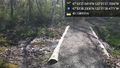
Heading back north, I ended up directly east of the point, then set off trail a few meters to the spot itself. Success!
On my way out, I took a different trail which would eventually connect with the school. Not far from the hashpoint, I found a little cave where a small stream (brook?) trickled down a 1.5 meter waterfall. Very cool!
Returning to my vehicle, I continued to Meeples Games, stopping briefly at the Dragonfly sculpture which is not far from the hashpoint. All cool things documented, the expedition came to an end.
Tracklog
Photos
South of here @47.5606,-122.3579
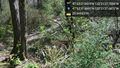
... and down. @47.5605,-122.3577
Meeting point for tomorrow's 4:00 expedition @47.5607,-122.3602
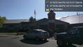
School @47.5629,-122.3569
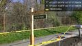
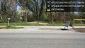
Sign @47.5603,-122.3603

Geohash! @47.5603,-122.3577
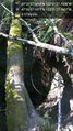
Grotto waterfall @47.5603,-122.3577
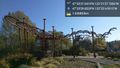
Dragonfly pavilion @47.5666,-122.3678


