Difference between revisions of "2016-04-14 52 1"
From Geohashing
imported>Sourcerer m ([live picture] Arrived. [http://www.openstreetmap.org/?lat=52.16429830&lon=1.46816075&zoom=16&layers=B000FTF @52.1643,1.4682]) |
imported>Sourcerer m ([live picture] Spuds! [http://www.openstreetmap.org/?lat=52.16414809&lon=1.46822512&zoom=16&layers=B000FTF @52.1641,1.4682]) |
||
| Line 24: | Line 24: | ||
Image:2016-04-14_52_1_Sourcerer_1460661207163.jpg | Arrived. [http://www.openstreetmap.org/?lat=52.16429830&lon=1.46816075&zoom=16&layers=B000FTF @52.1643,1.4682] | Image:2016-04-14_52_1_Sourcerer_1460661207163.jpg | Arrived. [http://www.openstreetmap.org/?lat=52.16429830&lon=1.46816075&zoom=16&layers=B000FTF @52.1643,1.4682] | ||
| + | |||
| + | Image:2016-04-14_52_1_Sourcerer_1460661225288.jpg | Spuds! [http://www.openstreetmap.org/?lat=52.16414809&lon=1.46822512&zoom=16&layers=B000FTF @52.1641,1.4682] | ||
</gallery> | </gallery> | ||
Revision as of 19:16, 14 April 2016
| Thu 14 Apr 2016 in Norwich, UK: 52.1642903, 1.4681409 geohashing.info google osm bing/os kml crox |
Location
In a field close to the entrance east of Blaxhall, Suffolk, UK.
Participants
Expedition
Photos
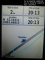
Arrived. @52.1643,1.4682
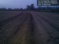
Spuds! @52.1641,1.4682


Achievements
Expeditions and Plans
| 2016-04-14 | ||
|---|---|---|
| Buffalo, New York | Pedalpusher | In an undeveloped (not as swampy as expected) area in Cheektowaga next to a... |
| Norwich, United Kingdom | Sourcerer | In a field close to the entrance east of Blaxhall, Suffolk, UK. |
| Kangasala, Finland | Tilley | Near the peninsula Muttamonkärki of lake Hauhonselkä. The point lies in the... |
Sourcerer's Expedition Links
2016-04-13 52 1 - 2016-04-14 52 1 - 2016-04-15 52 1 - KML file download of Sourcerer's expeditions for use with Google Earth.