Difference between revisions of "2016-04-18 49 8"
From Geohashing
imported>Q-Owl (Created page with "thumb|left|nnnnn {{meetup graticule | lat=49 | lon=8 | date=2016-04-18 }}__NOTOC__ == Location == Between Gernsheim...") |
imported>Q-Owl (→Expedition) |
||
| Line 20: | Line 20: | ||
== Expedition == | == Expedition == | ||
| + | Success! :-) | ||
<!-- We found a road, which led us near the the hashpoint and was not prohibited. To reach the hp we had to walk straight through a litte valley in the wood. Good to wear rainboots! | <!-- We found a road, which led us near the the hashpoint and was not prohibited. To reach the hp we had to walk straight through a litte valley in the wood. Good to wear rainboots! | ||
| Line 25: | Line 26: | ||
Later we found a few geocaches and so we had a nice afternoon outside. --> | Later we found a few geocaches and so we had a nice afternoon outside. --> | ||
| − | |||
== Photos == | == Photos == | ||
Revision as of 17:43, 18 April 2016

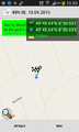
| Mon 18 Apr 2016 in 49,8: 49.7606532, 8.5154285 geohashing.info google osm bing/os kml crox |
Location
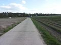
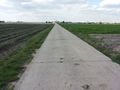
Between Gernsheim and Allmendfeld in the upper Rhine valley.
Participants
Plan
After work: Drive near the hashpoint between Gernsheim and Allmendfeld, walk to the hp, reach it about 17:00, walk back to the car and drive home.
Expedition
Success! :-)
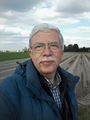
Photos
Proof

View E
View N
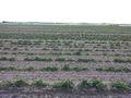
View W
View S
Grin


Achievements / Honorable Mention
Q-Owl & Q-Owla earned the Land geohash achievement
|
Other Geohashing Expeditions and Plans on this Day
Expeditions and Plans
| 2016-04-18 | ||
|---|---|---|
| Mannheim, Germany | Q-Owl | Between Gernsheim and Allmendfeld in the upper Rhine valley; located on a c... |
| Cambridge, United Kingdom | Sourcerer | A meadow divided into allotments near Pott Row, Norfolk, UK. |
| Norwich, United Kingdom | Sourcerer | A footpath point, south of Stalham, Norfolk, UK |