Difference between revisions of "2016-04-25 47 -122"
imported>Thomcat ([live picture]Under construction [http://www.openstreetmap.org/?lat=47.61401660&lon=-122.30888120&zoom=16&layers=B000FTF @47.6140,-122.3089]) |
imported>FippeBot m (Location) |
||
| (3 intermediate revisions by one other user not shown) | |||
| Line 19: | Line 19: | ||
== Expedition == | == Expedition == | ||
<!-- how it all turned out. your narrative goes here. --> | <!-- how it all turned out. your narrative goes here. --> | ||
| − | This hashpoint is on the street east of the former T.T. Minor elementary, | + | This hashpoint is on the street east of the former T.T. Minor elementary, most recently the home of the [[wikipedia:Hamlin_Robinson_School|Hamlin Robinson School]]. This area is known as [[wikipedia:Cherry_Hill,_Seattle|Cherry Hill]]. |
| + | |||
| + | On the way to the site after the [http://www.metroleaguewa.org/index.php?act=view&event_id=292117&league=8&page_name=event_page&school=73&sport=0|Baseball game], I swung by the new home of Hamlin Robinson (since June 2015). | ||
| + | |||
| + | Realizing I wanted to find a bathroom, I found facilities that were near a watering hole. Half an hour later, I was on the road to the geohash again. | ||
| + | |||
| + | Very close by, I passed the namesake of another favorite watering hole, snapping a picture for future reference. Will have to return there another time when I need more watering. | ||
| + | |||
| + | Finally, I turned onto geohash avenue itself. The school is under renovation, soon to be the home of Seattle World School, "a transitional learning center for refugee and immigrant students." Parking, I found the edge of street location for the hashpoint and snapped my grinning photo. As a grand finale, I zoomed in close and snapped the sign for the building project. | ||
| + | |||
| + | Quite the educational geohash! | ||
== Tracklog == | == Tracklog == | ||
| Line 30: | Line 40: | ||
<gallery perrow="5"> | <gallery perrow="5"> | ||
| − | Image:2016-04-25_47_-122_thomcat_1461631239158.jpg|The | + | Image:2016-04-25_47_-122_thomcat_1461631239158.jpg|The current Hamlin Robinson school [http://www.openstreetmap.org/?lat=47.58772010&lon=-122.30665990&zoom=16&layers=B000FTF @47.5877,-122.3067] |
Image:2016-04-25_47_-122_thomcat_1461632390665.jpg|Pit stop [http://www.openstreetmap.org/?lat=47.59946030&lon=-122.29968110&zoom=16&layers=B000FTF @47.5995,-122.2997] | Image:2016-04-25_47_-122_thomcat_1461632390665.jpg|Pit stop [http://www.openstreetmap.org/?lat=47.59946030&lon=-122.29968110&zoom=16&layers=B000FTF @47.5995,-122.2997] | ||
| Line 37: | Line 47: | ||
Image:2016-04-25_47_-122_thomcat_1461633930204.jpg|Under construction [http://www.openstreetmap.org/?lat=47.61401660&lon=-122.30888120&zoom=16&layers=B000FTF @47.6140,-122.3089] | Image:2016-04-25_47_-122_thomcat_1461633930204.jpg|Under construction [http://www.openstreetmap.org/?lat=47.61401660&lon=-122.30888120&zoom=16&layers=B000FTF @47.6140,-122.3089] | ||
| + | |||
| + | Image:2016-04-25_47_-122_thomcat_1461634119353.jpg|Geohasher [http://www.openstreetmap.org/?lat=47.61378100&lon=-122.30883750&zoom=16&layers=B000FTF @47.6138,-122.3088] | ||
| + | |||
| + | Image:2016-04-25_47_-122_thomcat_1461634171456.jpg|Zoom on sign [http://www.openstreetmap.org/?lat=47.61376490&lon=-122.30885470&zoom=16&layers=B000FTF @47.6138,-122.3089] | ||
</gallery> | </gallery> | ||
| Line 43: | Line 57: | ||
<!-- Add any achievement ribbons you earned below, or remove this section --> | <!-- Add any achievement ribbons you earned below, or remove this section --> | ||
| − | |||
| − | |||
| − | |||
| − | |||
[[Category:Expeditions]] | [[Category:Expeditions]] | ||
[[Category:Expeditions with photos]] | [[Category:Expeditions with photos]] | ||
[[Category:Coordinates reached]] | [[Category:Coordinates reached]] | ||
| − | + | {{location|US|WA|KN}} | |
| − | |||
| − | |||
| − | |||
| − | |||
| − | |||
| − | |||
| − | |||
| − | |||
| − | |||
| − | |||
Latest revision as of 00:20, 16 August 2019
| Mon 25 Apr 2016 in Seattle: 47.6137815, -122.3088384 geohashing.info google osm bing/os kml crox |
Location
On 18th avenue, across from the TT Minor building on Seattle's Capitol Hill.
Participants
Plans
Stop by after baseball, then head north to home.
Expedition
This hashpoint is on the street east of the former T.T. Minor elementary, most recently the home of the Hamlin Robinson School. This area is known as Cherry Hill.
On the way to the site after the game, I swung by the new home of Hamlin Robinson (since June 2015).
Realizing I wanted to find a bathroom, I found facilities that were near a watering hole. Half an hour later, I was on the road to the geohash again.
Very close by, I passed the namesake of another favorite watering hole, snapping a picture for future reference. Will have to return there another time when I need more watering.
Finally, I turned onto geohash avenue itself. The school is under renovation, soon to be the home of Seattle World School, "a transitional learning center for refugee and immigrant students." Parking, I found the edge of street location for the hashpoint and snapped my grinning photo. As a grand finale, I zoomed in close and snapped the sign for the building project.
Quite the educational geohash!
Tracklog
Photos
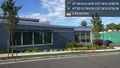
The current Hamlin Robinson school @47.5877,-122.3067
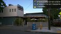
Pit stop @47.5995,-122.2997
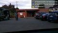
Chuck's! @47.6127,-122.3062
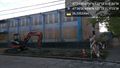
Under construction @47.6140,-122.3089

Geohasher @47.6138,-122.3088
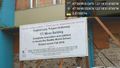
Zoom on sign @47.6138,-122.3089


