Difference between revisions of "2016-04-26 52 1"
imported>Sourcerer m ([live picture] Foiled. [http://www.openstreetmap.org/?lat=52.91895926&lon=1.34020329&zoom=16&layers=B000FTF @52.9190,1.3402]) |
m |
||
| (4 intermediate revisions by 2 users not shown) | |||
| Line 1: | Line 1: | ||
| − | + | {{meetup graticule | |
| − | |||
| − | |||
| − | |||
| − | |||
| − | |||
| − | |||
| − | |||
| − | |||
| − | |||
| − | {{meetup graticule | ||
| lat=52 | | lat=52 | ||
| lon=1 | | lon=1 | ||
| date=2016-04-26 | | date=2016-04-26 | ||
| + | | graticule_name=Norwich, UK | ||
| + | | graticule_link=Norwich, United Kingdom | ||
}} | }} | ||
| − | |||
| − | |||
__NOTOC__ | __NOTOC__ | ||
| + | == Location == | ||
| − | + | In the grounds of The Pleasaunce, Overstrand, Norfolk, UK. | |
| − | |||
== Participants == | == Participants == | ||
| − | + | ||
| − | + | *[[User:Sourcerer|Sourcerer]] | |
== Plans == | == Plans == | ||
| − | |||
| − | == Expedition == | + | One of two spanning midnight - [[2016-04-26 52 1]] - [[2016-04-27 52 1]] - ETA 23:00. |
| − | + | ||
| + | == Expedition - Fail == | ||
| − | + | Wind swept and hail beaten I drove round the circuit a couple of times and then walked the route looking for closer approaches. 33 metres away, I abandoned the attempt to close the final distance. The entrance to the zone was quite impressive but the hail was so heavy, I did not attempt a photo. According to TripAdvisor, the historically interesting Pleasaunce was, until recently, a specialist Christian holiday hotel. I don't know its current status. | |
| − | |||
== Photos == | == Photos == | ||
| − | + | ||
| − | |||
| − | |||
<gallery perrow="5"> | <gallery perrow="5"> | ||
| − | |||
Image:2016-04-26_52_1_Sourcerer_1461708419893.jpg | Foiled. [http://www.openstreetmap.org/?lat=52.91895926&lon=1.34020329&zoom=16&layers=B000FTF @52.9190,1.3402] | Image:2016-04-26_52_1_Sourcerer_1461708419893.jpg | Foiled. [http://www.openstreetmap.org/?lat=52.91895926&lon=1.34020329&zoom=16&layers=B000FTF @52.9190,1.3402] | ||
| + | Image:2016-04-26_52_1_Sourcerer.jpg | Google Earth Track | ||
</gallery> | </gallery> | ||
== Achievements == | == Achievements == | ||
{{#vardefine:ribbonwidth|800px}} | {{#vardefine:ribbonwidth|800px}} | ||
| − | |||
| − | + | {{Sourcerer_links | |
| − | + | | prev = 2016-04-24 52 1 | |
| − | + | | curr = 2016-04-26 52 1 | |
| + | | next = 2016-04-27 52 1 | ||
| + | | date = 2016-04-26 | ||
| + | }} | ||
| − | |||
| − | |||
| − | |||
| − | |||
| − | |||
| − | |||
| − | |||
| − | |||
[[Category:Expeditions]] | [[Category:Expeditions]] | ||
| − | |||
[[Category:Expeditions with photos]] | [[Category:Expeditions with photos]] | ||
| − | |||
| − | |||
| − | |||
| − | |||
| − | |||
| − | |||
| − | |||
| − | |||
| − | |||
[[Category:Coordinates not reached]] | [[Category:Coordinates not reached]] | ||
| − | |||
| − | |||
[[Category:Not reached - Mother Nature]] | [[Category:Not reached - Mother Nature]] | ||
| − | + | {{location|GB|ENG|NFK}} | |
| − | |||
| − | |||
| − | |||
| − | |||
| − | |||
| − | |||
| − | |||
| − | |||
| − | |||
| − | |||
Latest revision as of 11:46, 27 March 2022
| Tue 26 Apr 2016 in Norwich, UK: 52.9186499, 1.3404085 geohashing.info google osm bing/os kml crox |
Location
In the grounds of The Pleasaunce, Overstrand, Norfolk, UK.
Participants
Plans
One of two spanning midnight - 2016-04-26 52 1 - 2016-04-27 52 1 - ETA 23:00.
Expedition - Fail
Wind swept and hail beaten I drove round the circuit a couple of times and then walked the route looking for closer approaches. 33 metres away, I abandoned the attempt to close the final distance. The entrance to the zone was quite impressive but the hail was so heavy, I did not attempt a photo. According to TripAdvisor, the historically interesting Pleasaunce was, until recently, a specialist Christian holiday hotel. I don't know its current status.
Photos
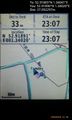
Foiled. @52.9190,1.3402
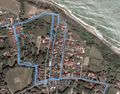
Google Earth Track


Achievements
Expeditions and Plans
| 2016-04-26 | ||
|---|---|---|
| Portland, Oregon | Jim | In a pond near Hwy 26 in Beaverton |
| Stuttgart, Germany | Drei aus Korb | Afalterbach / Landkreis Ludwigsburg |
| Norwich, United Kingdom | Sourcerer | In the grounds of The Pleasaunce, Overstrand, Norfolk, UK. |
Sourcerer's Expedition Links
2016-04-24 52 1 - 2016-04-26 52 1 - 2016-04-27 52 1 - KML file download of Sourcerer's expeditions for use with Google Earth.