Difference between revisions of "2016-05-03 52 1"
From Geohashing
imported>Sourcerer m ([live] Arrived.) |
imported>FippeBot m (Location) |
||
| (4 intermediate revisions by one other user not shown) | |||
| Line 21: | Line 21: | ||
== Expedition == | == Expedition == | ||
| + | *Arrived. -- [[User:Sourcerer|Sourcerer]] ([[User talk:Sourcerer|talk]]) [http://www.openstreetmap.org/?lat=52.62662530&lon=1.09185219&zoom=16&layers=B000FTF @52.6266,1.0919] 22:42, 3 May 2016 (GMT+01:00) | ||
| + | Garmin and Droid disagreed by 17 metres but I went to both points. Later I checked the waymark on the Garmin receiver. The two least significant longitude digits were wrong - finger trouble. Otherwise this was easy enough. It was a nice starry spring night. | ||
| − | |||
| − | |||
== Photos == | == Photos == | ||
<gallery perrow="5"> | <gallery perrow="5"> | ||
| + | Image:2016-05-03_52_1_Sourcerer_1462311618306.jpg | Proof [http://www.openstreetmap.org/?lat=52.62661457&lon=1.09185219&zoom=16&layers=B000FTF @52.6266,1.0919] | ||
| + | Image:2016-05-03_52_1_Sourcerer.jpg | Google Earth Track | ||
</gallery> | </gallery> | ||
| Line 40: | Line 42: | ||
}} | }} | ||
| − | |||
| − | |||
[[Category:Expeditions]] | [[Category:Expeditions]] | ||
[[Category:Expeditions with photos]] | [[Category:Expeditions with photos]] | ||
[[Category:Coordinates reached]] | [[Category:Coordinates reached]] | ||
| − | + | {{location|GB|ENG|NFK}} | |
Latest revision as of 00:25, 16 August 2019
| Tue 3 May 2016 in Norwich, UK: 52.6266169, 1.0918594 geohashing.info google osm bing/os kml crox |
Location
A field perimeter hashpoint close to a road, west of Barford, Norfolk, UK.
Participants
Plans
One of two spanning midnight - 2016-05-03 52 1 - 2016-05-04 52 1 - ETA 22:55.
Expedition
- Arrived. -- Sourcerer (talk) @52.6266,1.0919 22:42, 3 May 2016 (GMT+01:00)
Garmin and Droid disagreed by 17 metres but I went to both points. Later I checked the waymark on the Garmin receiver. The two least significant longitude digits were wrong - finger trouble. Otherwise this was easy enough. It was a nice starry spring night.
Photos
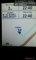
Proof @52.6266,1.0919
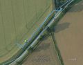
Google Earth Track


Achievements
Expeditions and Plans
| 2016-05-03 | ||
|---|---|---|
| Norwich, United Kingdom | Sourcerer | A field perimeter hashpoint close to a road, west of Barford, Norfolk, UK. |
| Nurmes, Finland | Pastori, The Wife | In Nurmes, Ylikylä. The point lies on a rocky patch of pine trees. |
Sourcerer's Expedition Links
2016-05-01 52 1 - 2016-05-03 52 1 - 2016-05-04 52 1 - KML file download of Sourcerer's expeditions for use with Google Earth.