Difference between revisions of "2016-05-05 52 1"
From Geohashing
imported>Sourcerer m ([live picture] Arrival. [http://www.openstreetmap.org/?lat=52.91334271&lon=1.11897469&zoom=16&layers=B000FTF @52.9133,1.1190]) |
imported>FippeBot m (Location) |
||
| (2 intermediate revisions by one other user not shown) | |||
| Line 21: | Line 21: | ||
== Expedition == | == Expedition == | ||
| − | + | There was a handy lay-by for parking. The hashpoint was about 10 paces into the woodland accessed by squeezing through a wooden fence between the high and low rail. This one was easy apart from my droid wanting to take me to the other side of the road. Phone GPS does not seem to work well under trees. Droid thought I was 27 metres away. Garmin and Google Earth were in good agreement though. | |
== Photos == | == Photos == | ||
<gallery perrow="5"> | <gallery perrow="5"> | ||
| − | |||
Image:2016-05-05_52_1_Sourcerer_1462481473499.jpg | Arrival. [http://www.openstreetmap.org/?lat=52.91334271&lon=1.11897469&zoom=16&layers=B000FTF @52.9133,1.1190] | Image:2016-05-05_52_1_Sourcerer_1462481473499.jpg | Arrival. [http://www.openstreetmap.org/?lat=52.91334271&lon=1.11897469&zoom=16&layers=B000FTF @52.9133,1.1190] | ||
| + | Image:2016-05-05_52_1_Sourcerer.jpg | Google Earth Track | ||
</gallery> | </gallery> | ||
| Line 40: | Line 40: | ||
}} | }} | ||
| − | |||
| − | |||
[[Category:Expeditions]] | [[Category:Expeditions]] | ||
[[Category:Expeditions with photos]] | [[Category:Expeditions with photos]] | ||
[[Category:Coordinates reached]] | [[Category:Coordinates reached]] | ||
| − | + | {{location|GB|ENG|NFK}} | |
Latest revision as of 00:26, 16 August 2019
| Thu 5 May 2016 in Norwich, UK: 52.9130918, 1.1188644 geohashing.info google osm bing/os kml crox |
Location
In woodland close to the A148 at High Kelling east of Holt, Norfolk, UK.
Participants
Plans
One of two spanning midnight - 2016-05-05 52 1 - 2016-05-06 52 1 - ETA 21:55.
Expedition
There was a handy lay-by for parking. The hashpoint was about 10 paces into the woodland accessed by squeezing through a wooden fence between the high and low rail. This one was easy apart from my droid wanting to take me to the other side of the road. Phone GPS does not seem to work well under trees. Droid thought I was 27 metres away. Garmin and Google Earth were in good agreement though.
Photos
Arrival. @52.9133,1.1190
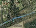
Google Earth Track


Achievements
Expeditions and Plans
| 2016-05-05 | ||
|---|---|---|
| Grand Rapids, Michigan | Mcbaneg | Back lawn of a condominium complex, Byron Center, MI |
| Nürnberg, Germany | Klaus | between Laibaroes und Geisdorf |
| Erfurt, Germany | Manu, Reinhard, Pico | In a field near Schellroda/Erfurt, Thuringia, Germany. |
| Norwich, United Kingdom | Sourcerer | In woodland close to the A148 at High Kelling east of Holt, Norfolk, UK. |
Sourcerer's Expedition Links
2016-05-04 52 1 - 2016-05-05 52 1 - 2016-05-06 52 1 - KML file download of Sourcerer's expeditions for use with Google Earth.