Difference between revisions of "2016-05-12 52 1"
From Geohashing
imported>Sourcerer (→Planning) |
imported>FippeBot m (Location) |
||
| (4 intermediate revisions by one other user not shown) | |||
| Line 21: | Line 21: | ||
== Expedition == | == Expedition == | ||
| + | *Arrived. -- [[User:Sourcerer|Sourcerer]] ([[User talk:Sourcerer|talk]]) [http://www.openstreetmap.org/?lat=52.43059874&lon=1.33759618&zoom=16&layers=B000FTF @52.4306,1.3376] 23:56, 11 May 2016 (GMT+01:00) | ||
| + | |||
| + | I arrived a few minutes early and hung around until midnight to upload my evidence photo taken a bit earlier. The page history time-stamp shows 41 seconds after midnight. The hashpoint was in the middle of a field boundary hedge. There was an unlocked gate leading into into the field but it was not obvious that I could get any closer from the other side of the wide hedge so I didn't bother. | ||
== Photos == | == Photos == | ||
<gallery perrow="5"> | <gallery perrow="5"> | ||
| + | Image:2016-05-12_52_1_Sourcerer_1463007243139.jpg | Now midnight. [http://www.openstreetmap.org/?lat=52.43058264&lon=1.33759618&zoom=16&layers=B000FTF @52.4306,1.3376] | ||
| + | Image:2016-05-12 52 1 Sourcerer.jpg | Google Earth Track | ||
</gallery> | </gallery> | ||
== Achievements == | == Achievements == | ||
{{#vardefine:ribbonwidth|800px}} | {{#vardefine:ribbonwidth|800px}} | ||
| + | |||
| + | {{Midnight geohash | ||
| + | | latitude = 52 | ||
| + | | longitude = 1 | ||
| + | | date = 2016-05-12 | ||
| + | | name = Sourcerer | ||
| + | }} | ||
{{Sourcerer_links | {{Sourcerer_links | ||
| prev = 2016-05-11 52 1 | | prev = 2016-05-11 52 1 | ||
| curr = 2016-05-12 52 1 | | curr = 2016-05-12 52 1 | ||
| − | | next = 2016-05-13 | + | | next = 2016-05-13 51 1 |
| date = 2016-05-12 | | date = 2016-05-12 | ||
}} | }} | ||
| − | |||
| − | |||
[[Category:Expeditions]] | [[Category:Expeditions]] | ||
[[Category:Expeditions with photos]] | [[Category:Expeditions with photos]] | ||
[[Category:Coordinates reached]] | [[Category:Coordinates reached]] | ||
| − | + | {{location|GB|ENG|NFK}} | |
Latest revision as of 00:30, 16 August 2019
| Thu 12 May 2016 in Norwich, UK: 52.4305283, 1.3376619 geohashing.info google osm bing/os kml crox |
Location
A field between Piccadilly Corner and Alburgh, Norfolk, UK.
Participants
Plans
Two of two spanning midnight - 2016-05-11 52 1 - 2016-05-12 52 1 - ETA 00:00.
Expedition
- Arrived. -- Sourcerer (talk) @52.4306,1.3376 23:56, 11 May 2016 (GMT+01:00)
I arrived a few minutes early and hung around until midnight to upload my evidence photo taken a bit earlier. The page history time-stamp shows 41 seconds after midnight. The hashpoint was in the middle of a field boundary hedge. There was an unlocked gate leading into into the field but it was not obvious that I could get any closer from the other side of the wide hedge so I didn't bother.
Photos
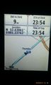
Now midnight. @52.4306,1.3376
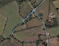
Google Earth Track


Achievements
Sourcerer earned the Midnight Geohash achievement
|
Expeditions and Plans
| 2016-05-12 | ||
|---|---|---|
| Norwich, United Kingdom | Sourcerer | A field between Piccadilly Corner and Alburgh, Norfolk, UK. |
| Turku, Finland | Suurnesu | In front of some private houses near Lauste in Turku |
Sourcerer's Expedition Links
2016-05-11 52 1 - 2016-05-12 52 1 - 2016-05-13 51 1 - KML file download of Sourcerer's expeditions for use with Google Earth.