Difference between revisions of "2016-05-15 52 1"
imported>Sourcerer m (→Achievements) |
imported>Sourcerer m (→New expedition) |
||
| Line 30: | Line 30: | ||
== Expedition == | == Expedition == | ||
| + | === Sourcerer - Not Reached by 15 metres === | ||
| + | At 15:10 after a short drive and walk Sourcerer got to within 15 metres of the hashpoint which was in the river, as expected. The temperature was 11 or 12C and there was a threatening rain cloud and a stiff breeze spoiling the day. Not far north, it was sunny. There followed a chilly hour of waiting around. There were a few nice photo opportunities as boats passed. Then I got a [https://youtu.be/djlZ1ACA488 video] of a very furry caterpillar. | ||
| + | A small boat approached and I wondered if I could hitch a lift. It turned out the be the official Broads Authority police boat so I decided not to interrupt their day. | ||
| + | |||
| + | At 4pm on the dot, there was the yellow peril in the distance. | ||
*Met Mr and Mrs PaintedJaguar. Coordinates reached. -- [[User:Sourcerer|Sourcerer]] ([[User talk:Sourcerer|talk]]) [http://www.openstreetmap.org/?lat=52.55941451&lon=1.52549028&zoom=16&layers=B000FTF @52.5594,1.5255] 16:05, 15 May 2016 (GMT+01:00) | *Met Mr and Mrs PaintedJaguar. Coordinates reached. -- [[User:Sourcerer|Sourcerer]] ([[User talk:Sourcerer|talk]]) [http://www.openstreetmap.org/?lat=52.55941451&lon=1.52549028&zoom=16&layers=B000FTF @52.5594,1.5255] 16:05, 15 May 2016 (GMT+01:00) | ||
| + | |||
| + | I signalled using semaphore (which I don't know) so my message was random garbage. Pearl Horizon sailed past at speed and I wondered what was going on. Perhaps I'd signalled the wrong boat. "Why is that lunatic gesticulating at us?" Then the boat made a 180 degree turn and came close to the reeds, sadly too fast for me to jump on. 360 degrees later, a second attempt was worse but the boat was now the right distance off-shore to pass the hashpoint close enough for "coordinates reached". We exchanged a few words and decided it was not really safe to attempt a jump. A zero speed nose-on approach might have worked. We exchanged a few more words and mentioned our hope to meet on Geohashing day only six more days away. | ||
| + | |||
| + | === PaintedJaguar - Coordinates Reached === | ||
| + | |||
| + | |||
| + | |||
== Photos == | == Photos == | ||
<gallery perrow="5"> | <gallery perrow="5"> | ||
| − | |||
Image:2016-05-15_52_1_Sourcerer_1463321417979.jpg | 15 Metres away. [http://www.openstreetmap.org/?lat=52.55984366&lon=1.52565122&zoom=16&layers=B000FTF @52.5598,1.5257] | Image:2016-05-15_52_1_Sourcerer_1463321417979.jpg | 15 Metres away. [http://www.openstreetmap.org/?lat=52.55984366&lon=1.52565122&zoom=16&layers=B000FTF @52.5598,1.5257] | ||
| + | Image:2016-05-15 52 1 Sourcerer Track.jpg | Google Earth Track | ||
| + | Image:2016-05-15 52 1 Sourcerer Sail.jpg | Sail Power | ||
| + | Image:2016-05-15 52 1 Sourcerer Yare.jpg | River Yare | ||
| + | Image:2016-05-15 52 1 Sourcerer Hardley Cut.jpg | Hardley Cut | ||
| + | Image:2016-05-15 52 1 Sourcerer Cantley Sugar.jpg | Cantley Sugar Factory | ||
| + | Image:2016-05-15 52 1 Sourcerer Pearl Horizon 1.jpg | Pearl Horizon One | ||
</gallery> | </gallery> | ||
| Line 65: | Line 82: | ||
[[Category:Expeditions]] | [[Category:Expeditions]] | ||
[[Category:Expeditions with photos]] | [[Category:Expeditions with photos]] | ||
| + | [[Category:Expeditions with videos]] | ||
[[Category:Coordinates reached]] | [[Category:Coordinates reached]] | ||
Revision as of 16:29, 15 May 2016
| Sun 15 May 2016 in Norwich, UK: 52.5599498, 1.5258119 geohashing.info google osm bing/os kml crox |
Location
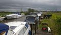
Halfway across the River Yare at the end of the cut at Hardley Staithe, Norfolk, UK. Boaty McBoatface!
Participants
- Sourcerer
- PaintedJaguar
- MrsPaintedJaguar
Plans
Sourcerer
Updated: Dress up as a pirate and capture PaintedJaguar's boat!
PaintedJaguar and MrsPaintedJaguar
The PaintedJaguars already have a holiday booked on the Norfolk Broads this weekend! Does this qualify for some kind of pre-emptive award? We're hiring from the Northern half of the Broads, and the tidally restricted crossing time for Great Yarmouth/Breydon Water is 12:45, with approximately two hours of travel time to the hashpoint from there. Factoring in a late-lunch-pub-stop on the way suggests we'll arrive at around 4pm (cool, but shame it's not a Saturday), although we could easily be an hour or so off that time either way.
We'll be in a bright yellow boat called Pearl Horizon 1 if Sourcerer (or anyone else) wants to look out for us anywhere between Great Yarmouth and the hashpoint sometime in the afternoon. Future internet access may be limited for us, so apologies if we don't contribute to any further planning discussion.
Expedition
Sourcerer - Not Reached by 15 metres
At 15:10 after a short drive and walk Sourcerer got to within 15 metres of the hashpoint which was in the river, as expected. The temperature was 11 or 12C and there was a threatening rain cloud and a stiff breeze spoiling the day. Not far north, it was sunny. There followed a chilly hour of waiting around. There were a few nice photo opportunities as boats passed. Then I got a video of a very furry caterpillar.
A small boat approached and I wondered if I could hitch a lift. It turned out the be the official Broads Authority police boat so I decided not to interrupt their day.
At 4pm on the dot, there was the yellow peril in the distance.
- Met Mr and Mrs PaintedJaguar. Coordinates reached. -- Sourcerer (talk) @52.5594,1.5255 16:05, 15 May 2016 (GMT+01:00)
I signalled using semaphore (which I don't know) so my message was random garbage. Pearl Horizon sailed past at speed and I wondered what was going on. Perhaps I'd signalled the wrong boat. "Why is that lunatic gesticulating at us?" Then the boat made a 180 degree turn and came close to the reeds, sadly too fast for me to jump on. 360 degrees later, a second attempt was worse but the boat was now the right distance off-shore to pass the hashpoint close enough for "coordinates reached". We exchanged a few words and decided it was not really safe to attempt a jump. A zero speed nose-on approach might have worked. We exchanged a few more words and mentioned our hope to meet on Geohashing day only six more days away.
PaintedJaguar - Coordinates Reached
Photos
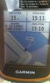
15 Metres away. @52.5598,1.5257
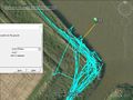
Google Earth Track
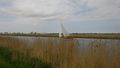
Sail Power
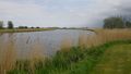
River Yare
Hardley Cut
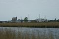
Cantley Sugar Factory
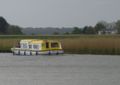
Pearl Horizon One


Achievements

PaintedJaguar earned the Precognition Award
|
Expeditions and Plans
| 2016-05-15 | ||
|---|---|---|
| Portland, Oregon | Jim | In the North Portland Costco parking lot |
| Norwich, United Kingdom | Sourcerer, PaintedJaguar, MrsPaintedJaguar | Halfway across the River Yare at the end of the cut at Hardley Staithe, Nor... |
Sourcerer's Expedition Links
2016-05-14 52 1 - 2016-05-15 52 1 - 2016-05-16 52 1 - KML file download of Sourcerer's expeditions for use with Google Earth.