Difference between revisions of "2016-05-21 47 10"
imported>B2c ([live] Will try tomorrow.) |
m (Linking to The Dance™) |
||
| (20 intermediate revisions by 3 users not shown) | |||
| Line 1: | Line 1: | ||
| − | |||
| − | |||
| − | |||
| − | |||
| − | |||
| − | |||
| − | |||
| − | |||
| − | |||
| − | |||
{{meetup graticule | {{meetup graticule | ||
| lat=47 | | lat=47 | ||
| Line 15: | Line 5: | ||
}} | }} | ||
| − | + | == Location == | |
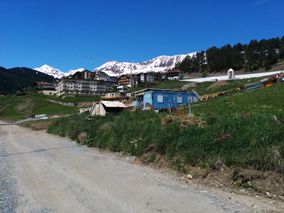
| − | + | [[Image:2016-05-21-47_10-hashpoint-hill.jpg | thumb | left | On a hillslope below Serfaus in Tyrolia, western Austria.]] | |
| + | |||
| + | |||
| + | |||
| + | |||
| + | |||
| + | |||
| + | |||
| − | |||
| − | |||
== Participants == | == Participants == | ||
| − | + | * [[User:B2c|B2c]] | |
| − | + | * Izzy | |
== Plans == | == Plans == | ||
| − | + | B2c and Izzy are planning to check out tomorrows hashpoint near Serfaus, located near a relatives home near Fließ in Tyrolia, western Austria. The hashpoint is located at the edge of the town on a meadow on a hillside. Although B2c had planned to go hashing with his favorite hashbuddies [[User:Micsnare|Micsnare]] and [[User:Crankl|Crankl]] in 48 16, his plans channged as he is on holiday visiting relatives right now. So this geohash is a somewhat distributed operation with the four of them hashing in parallel in [[2016-05-21_47_10]] and [[2016-05-21_48_16]]. | |
| + | |||
| + | Edit1: this is getting better by the minute, as [[User:OtherJack|OtherJack]] joined in on this and will try a holy geohash in [[2016-05-21_41_-73]] (New York)! | ||
| + | |||
| + | Edit2: B2c also pinged fellow hasher [[User:LeslieHapablap|LeslieHapablap]], but he was in Freiburg (Germany) at the time and unsure if he could go hashing. | ||
| + | |||
== Expedition == | == Expedition == | ||
| − | + | B2c picked up Izzy at his workplace at around 11am as he had an extended five hour lunch break, which was ideal as the whole trip to the hashpoint, visiting relatives on the way and driving back to Innsbruck was expected to take around four to five hours total. Izzy knew the way quite well as he was visiting the area quite often, and the hashpoint was located on the opposite side of the valley where their relatives where residing. They had to drive on the motorway along the Inn Valley (Inntal) and took a turn to the southwest at Landeck into the Kauner Valley (Kaunertal), which is well known for its beautiful landscape and overflowing touristic development. Passing the mountain Tschirgant which stands tall and solitary at the entrance to the valley like a giant forgotten pyramid they took to a steep and winding road leading up the western valleyside. After a taxing hillclimb (for the old hashmobile at least ;) they arrived at the small town of Fließ, which seemed to consist mostly of Hotels and Apres-Ski bars. They had a little trouble navigating the small alleys but finally managed to park the hashmobile at the and of a construction site next to some kind of apartment building. From there on they went along a small access road next to some more construction sites and a seemingly out-of-place soccer ground. Turning right at its end walking up a hillside they arrived at the hashpoint. GPS reception was excellent for once and they were spared [[The Dance™|the dance]], immediately allowing them to proceed with taking pictures and recording proof. Admiring the fabulous view in the excellent weather they stood there for a while in awe before walking back to the car and driving onwards to go visit their relatives. After a hearty hello some banter ensued and they were offered drinks and self-baked tomato bread. Refreshed and well-set day they drove back to Innsbruck to end their expedition. | |
| + | == Tracklog == | ||
| + | [[File:2015-05-21-47_10-tracklog.png]] | ||
| − | |||
| − | |||
| − | |||
| − | == Photos == | + | == Photos == |
| − | < | + | <gallery caption="Photo Gallery" widths="320px" heights="213px" perrow="3"> |
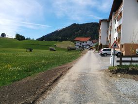
| − | Image: | + | Image:2016-05-21-47_10-car.jpg | View back, along the access road. |
| − | -- | + | Image:2016-05-21-47_10-hotels.jpg | Tourism hitting hard. |
| − | + | Image:2016-05-21-47_10-houses.jpg | Hashpoint from afar, on the hill to the right. | |
| + | Image:2016-05-21-47_10-football.jpg | A soccer ground was least expected around here. | ||
| + | Image:2016-05-21-47_10-hashpoint-hill.jpg | Approaching the hashpoint. | ||
| + | Image:2016-05-21-47_10-hashview.jpg | Beautiful mountain view from the hashpoint. | ||
| + | Image:2016-05-21-47_10-izzy.jpg | Thumbs up, Izzy. | ||
| + | Image:2016-05-21-47_10-stupidgrin.jpg | Stupid grin (tm). | ||
| + | Image:2016-05-21-47_10-proof.png | Proof. | ||
| + | Image:2016-05-21-47_10-moreproof.png | More Proof. | ||
</gallery> | </gallery> | ||
| + | |||
== Achievements == | == Achievements == | ||
| − | {{ | + | {{Geohashing Day |
| − | + | | latitude = 47 | |
| + | | longitude = 10 | ||
| + | | year = 2016 | ||
| + | | coorddate= 2016-05-21 | ||
| + | | name = [[User:B2c|B2c]] | ||
| + | | celebration = commemorating in awe | ||
| + | }} | ||
| − | + | {{Geohashing Day | |
| − | + | | latitude = 47 | |
| − | + | | longitude = 10 | |
| + | | year = 2016 | ||
| + | | coorddate= 2016-05-21 | ||
| + | | name = Izzy | ||
| + | | celebration = commemorating in awe | ||
| + | }} | ||
| − | |||
| − | |||
| − | |||
| − | |||
| − | |||
| − | |||
| − | |||
| − | |||
[[Category:Expeditions]] | [[Category:Expeditions]] | ||
| − | |||
[[Category:Expeditions with photos]] | [[Category:Expeditions with photos]] | ||
| − | |||
| − | |||
| − | |||
| − | |||
| − | |||
[[Category:Coordinates reached]] | [[Category:Coordinates reached]] | ||
| − | + | {{location|AT|T|LA}} | |
| − | |||
| − | |||
| − | |||
| − | |||
| − | |||
| − | |||
| − | |||
| − | |||
| − | |||
| − | |||
| − | |||
| − | |||
| − | |||
| − | |||
| − | |||
| − | |||
| − | |||
Latest revision as of 17:05, 14 November 2020
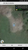
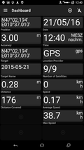
| Sat 21 May 2016 in 47,10: 47.0365641, 10.6168378 geohashing.info google osm bing/os kml crox |
Location

Participants
- B2c
- Izzy
Plans
B2c and Izzy are planning to check out tomorrows hashpoint near Serfaus, located near a relatives home near Fließ in Tyrolia, western Austria. The hashpoint is located at the edge of the town on a meadow on a hillside. Although B2c had planned to go hashing with his favorite hashbuddies Micsnare and Crankl in 48 16, his plans channged as he is on holiday visiting relatives right now. So this geohash is a somewhat distributed operation with the four of them hashing in parallel in 2016-05-21_47_10 and 2016-05-21_48_16.
Edit1: this is getting better by the minute, as OtherJack joined in on this and will try a holy geohash in 2016-05-21_41_-73 (New York)!
Edit2: B2c also pinged fellow hasher LeslieHapablap, but he was in Freiburg (Germany) at the time and unsure if he could go hashing.
Expedition
B2c picked up Izzy at his workplace at around 11am as he had an extended five hour lunch break, which was ideal as the whole trip to the hashpoint, visiting relatives on the way and driving back to Innsbruck was expected to take around four to five hours total. Izzy knew the way quite well as he was visiting the area quite often, and the hashpoint was located on the opposite side of the valley where their relatives where residing. They had to drive on the motorway along the Inn Valley (Inntal) and took a turn to the southwest at Landeck into the Kauner Valley (Kaunertal), which is well known for its beautiful landscape and overflowing touristic development. Passing the mountain Tschirgant which stands tall and solitary at the entrance to the valley like a giant forgotten pyramid they took to a steep and winding road leading up the western valleyside. After a taxing hillclimb (for the old hashmobile at least ;) they arrived at the small town of Fließ, which seemed to consist mostly of Hotels and Apres-Ski bars. They had a little trouble navigating the small alleys but finally managed to park the hashmobile at the and of a construction site next to some kind of apartment building. From there on they went along a small access road next to some more construction sites and a seemingly out-of-place soccer ground. Turning right at its end walking up a hillside they arrived at the hashpoint. GPS reception was excellent for once and they were spared the dance, immediately allowing them to proceed with taking pictures and recording proof. Admiring the fabulous view in the excellent weather they stood there for a while in awe before walking back to the car and driving onwards to go visit their relatives. After a hearty hello some banter ensued and they were offered drinks and self-baked tomato bread. Refreshed and well-set day they drove back to Innsbruck to end their expedition.
Tracklog

Photos
- Photo Gallery
View back, along the access road.
Tourism hitting hard.
Hashpoint from afar, on the hill to the right.
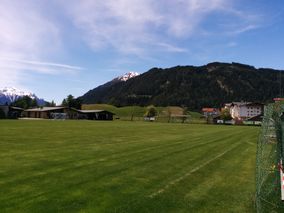
A soccer ground was least expected around here.
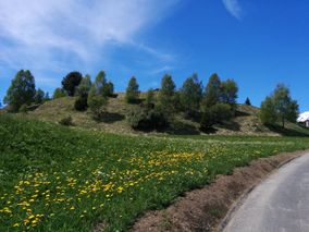
Approaching the hashpoint.
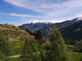
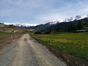
Beautiful mountain view from the hashpoint.
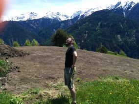
Thumbs up, Izzy.
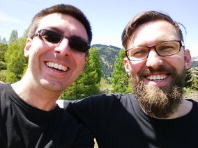
Stupid grin (tm).
Proof.
More Proof.


Achievements
B2c earned the 2016 Geohashing Day achievement
|
Izzy earned the 2016 Geohashing Day achievement
|