Difference between revisions of "2016-05-31 52 -3"
From Geohashing
imported>Sourcerer m (Arrived. [http://www.openstreetmap.org/?lat=52.13417172&lon=-3.68457198&zoom=16&layers=B000FTF @52.1342,-3.6846]) |
imported>Sourcerer m (→New expedition) |
||
| Line 1: | Line 1: | ||
| − | |||
| − | |||
| − | |||
| − | |||
| − | |||
| − | |||
| − | |||
| − | |||
| − | |||
| − | |||
{{meetup graticule | {{meetup graticule | ||
| lat=52 | | lat=52 | ||
| Line 14: | Line 4: | ||
| date=2016-05-31 | | date=2016-05-31 | ||
}} | }} | ||
| − | |||
| − | |||
__NOTOC__ | __NOTOC__ | ||
== Location == | == Location == | ||
| − | + | ||
| + | Between and west of Llanwrtyd and Abergwesyn, Powys, Cwmry. | ||
== Participants == | == Participants == | ||
| − | + | ||
| − | + | [[User:Sourcerer|Sourcerer]] | |
== Plans == | == Plans == | ||
| − | + | ||
| + | Set out as early as possible from friends in Colwyn Bay and head for mid Wales. | ||
== Expedition == | == Expedition == | ||
| − | |||
| − | + | I've washed off the dried blood. Here is the first draft. This was a long expedition. Road access to mid Wales is not great and the country is bigger that you might think. Setting out at 10:50 in beautiful sun shine, it took until 15:00 to reach the parking place. The outward walk in hazy sun and a stiff breeze took 1 hour 40 minutes. The return was the same but there was a good pause for sandwiches and a drink. The total distance walked was 9.1 km. The entire track log was 682 km. | |
| − | + | ||
| + | More to follow ... | ||
== Photos == | == Photos == | ||
| − | |||
| − | |||
| − | |||
<gallery perrow="5"> | <gallery perrow="5"> | ||
| − | |||
Image:2016-05-31_52_-3_Sourcerer_1464709016264.jpg | Arrived. [http://www.openstreetmap.org/?lat=52.13417172&lon=-3.68457198&zoom=16&layers=B000FTF @52.1342,-3.6846] | Image:2016-05-31_52_-3_Sourcerer_1464709016264.jpg | Arrived. [http://www.openstreetmap.org/?lat=52.13417172&lon=-3.68457198&zoom=16&layers=B000FTF @52.1342,-3.6846] | ||
| + | Image:2016-05-31 52 -3 Sourcerer Track 1.jpg | Entire Journey | ||
| + | Image:2016-05-31 52 -3 Sourcerer Track 2.jpg | Near the Hashpoint | ||
| + | Image:2016-05-31 52 -3 Sourcerer Track Stupidity.jpg | Stupidity Distance | ||
| + | Image:2016-05-31 52 -3 Sourcerer Profile.jpg | Altitude | ||
</gallery> | </gallery> | ||
== Achievements == | == Achievements == | ||
{{#vardefine:ribbonwidth|800px}} | {{#vardefine:ribbonwidth|800px}} | ||
| − | |||
| − | |||
| − | |||
| − | |||
| − | |||
| − | |||
| − | |||
| − | |||
| − | |||
| − | |||
| − | |||
| − | |||
| − | |||
[[Category:Expeditions]] | [[Category:Expeditions]] | ||
| − | |||
[[Category:Expeditions with photos]] | [[Category:Expeditions with photos]] | ||
| − | |||
| − | |||
| − | |||
| − | |||
| − | |||
[[Category:Coordinates reached]] | [[Category:Coordinates reached]] | ||
| − | |||
| − | |||
| − | |||
| − | |||
| − | |||
| − | |||
| − | |||
| − | |||
| − | |||
| − | |||
| − | |||
| − | |||
| − | |||
| − | |||
| − | |||
| − | |||
| − | |||
| − | |||
Revision as of 01:37, 1 June 2016
| Tue 31 May 2016 in 52,-3: 52.1324343, -3.6929796 geohashing.info google osm bing/os kml crox |
Location
Between and west of Llanwrtyd and Abergwesyn, Powys, Cwmry.
Participants
Plans
Set out as early as possible from friends in Colwyn Bay and head for mid Wales.
Expedition
I've washed off the dried blood. Here is the first draft. This was a long expedition. Road access to mid Wales is not great and the country is bigger that you might think. Setting out at 10:50 in beautiful sun shine, it took until 15:00 to reach the parking place. The outward walk in hazy sun and a stiff breeze took 1 hour 40 minutes. The return was the same but there was a good pause for sandwiches and a drink. The total distance walked was 9.1 km. The entire track log was 682 km.
More to follow ...
Photos
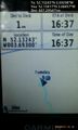
Arrived. @52.1342,-3.6846
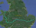
Entire Journey
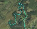
Near the Hashpoint
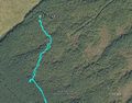
Stupidity Distance

Altitude


