Difference between revisions of "2016-06-07 52 1"
imported>Sourcerer m (→Plans) |
imported>FippeBot m (Location) |
||
| (6 intermediate revisions by one other user not shown) | |||
| Line 21: | Line 21: | ||
== Expedition == | == Expedition == | ||
| + | *Arrived. -- [[User:Sourcerer|Sourcerer]] ([[User talk:Sourcerer|talk]]) [http://www.openstreetmap.org/?lat=52.71115780&lon=1.70075119&zoom=16&layers=B000FTF @52.7112,1.7008] 20:14, 7 June 2016 (GMT+01:00) | ||
| + | This was pretty standard. Drive somewhere. Get carved up by an aggressive idiot competing for road space who then turned off returning him and me to our original places in the traffic. Walk a bit over a kilometre taking some pictures after the shuffle at the hashpoint. Enjoy the warmer weather. Wonder about the single large rain drop that fell earlier. The walk was a Tron. The drive home was not. | ||
== Photos == | == Photos == | ||
<gallery perrow="5"> | <gallery perrow="5"> | ||
| + | Image:2016-06-07_52_1_Sourcerer_1465326831491.jpg | Proof. [http://www.openstreetmap.org/?lat=52.71115780&lon=1.70075119&zoom=16&layers=B000FTF @52.7112,1.7008] | ||
| + | Image:2016-06-07 52 1 Sourcerer 1.jpg | Google Earth Track | ||
| + | Image:2016-06-07 52 1 Sourcerer 2.jpg | Hashpoint view | ||
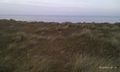
| + | Image:2016-06-07 52 1 Sourcerer 3.jpg | Hashpoint light house | ||
| + | Image:2016-06-07 52 1 Sourcerer 4.jpg | Hashpoint plants | ||
| + | Image:2016-06-07 52 1 Sourcerer 5.jpg | Hashpoint sea view | ||
| + | Image:2016-06-07 52 1 Sourcerer 6.jpg | Hashpoint sunset | ||
</gallery> | </gallery> | ||
| Line 35: | Line 44: | ||
| prev = 2016-06-02 52 1 | | prev = 2016-06-02 52 1 | ||
| curr = 2016-06-07 52 1 | | curr = 2016-06-07 52 1 | ||
| − | | next = 2016-06- | + | | next = 2016-06-09 52 0 |
| date = 2016-06-07 | | date = 2016-06-07 | ||
}} | }} | ||
| − | |||
| − | |||
[[Category:Expeditions]] | [[Category:Expeditions]] | ||
[[Category:Expeditions with photos]] | [[Category:Expeditions with photos]] | ||
[[Category:Coordinates reached]] | [[Category:Coordinates reached]] | ||
| − | + | {{location|GB|ENG|NFK}} | |
Latest revision as of 00:43, 16 August 2019
| Tue 7 Jun 2016 in Norwich, UK: 52.7111615, 1.7007459 geohashing.info google osm bing/os kml crox |
Location
Sand dunes south of Winterton-on-sea, Norfolk, UK.
Plans
Wait for the traffic to subside before heading for this one.
Participants
Expedition
- Arrived. -- Sourcerer (talk) @52.7112,1.7008 20:14, 7 June 2016 (GMT+01:00)
This was pretty standard. Drive somewhere. Get carved up by an aggressive idiot competing for road space who then turned off returning him and me to our original places in the traffic. Walk a bit over a kilometre taking some pictures after the shuffle at the hashpoint. Enjoy the warmer weather. Wonder about the single large rain drop that fell earlier. The walk was a Tron. The drive home was not.
Photos
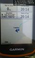
Proof. @52.7112,1.7008
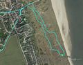
Google Earth Track
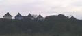
Hashpoint view
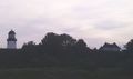
Hashpoint light house
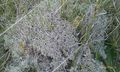
Hashpoint plants
Hashpoint sea view
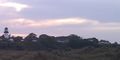
Hashpoint sunset


Achievements
Expeditions and Plans
| 2016-06-07 | ||
|---|---|---|
| Los Angeles, California | McKay | In a business complex in San Fernando Valley |
| Milano, Italy | Rmeht | Citta' Dei Mille Tennis Club |
| Mannheim, Germany | Q-Owl | In Reichenbach (Lautertal), Hesse. |
| Norwich, United Kingdom | Sourcerer | Sand dunes south of Winterton-on-sea, Norfolk, UK. |
| Nilsiä, Finland | Pastori, The Wife | Koppelo, Valtimo, at the side of the road. |
Sourcerer's Expedition Links
2016-06-02 52 1 - 2016-06-07 52 1 - 2016-06-09 52 0 - KML file download of Sourcerer's expeditions for use with Google Earth.