Difference between revisions of "2016-07-08 52 1"
From Geohashing
imported>Sourcerer m (→New expedition) |
imported>FippeBot m (Location) |
||
| Line 43: | Line 43: | ||
[[Category:Expeditions with photos]] | [[Category:Expeditions with photos]] | ||
[[Category:Coordinates reached]] | [[Category:Coordinates reached]] | ||
| + | {{location|GB|ENG|SFK}} | ||
Latest revision as of 00:56, 16 August 2019
| Fri 8 Jul 2016 in Norwich, UK: 52.0772587, 1.2192315 geohashing.info google osm bing/os kml crox |
Location
In a field between Rushmere St. Andrew and Playford, Suffolk, UK.
Participants
Plans
One of two spanning midnight - 2016-07-08 52 1 - 2016-07-09 52 1 - ETA 22:50.
Expedition
There was a parking place in the field entrance. Tractor tracks led very close to the hashpoint. The third track succeeded. The crop was nearly ripe barley.
Photos
- Photo Gallery
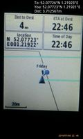
Arrived. @52.0772,1.2192
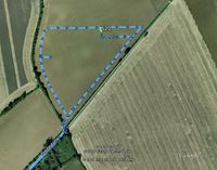
Google Earth Track


Achievements
Expeditions and Plans
| 2016-07-08 | ||
|---|---|---|
| Norwich, United Kingdom | Sourcerer | In a field between Rushmere St. Andrew and Playford, Suffolk, UK. |
| Groningen, Netherlands | FelixTheCat | In a forest in Wijnjewoude, Friesland. |
Sourcerer's Expedition Links
2016-07-05 52 1 - 2016-07-08 52 1 - 2016-07-09 52 1 - KML file download of Sourcerer's expeditions for use with Google Earth.