Difference between revisions of "2016-07-13 51 9"
From Geohashing
imported>GeorgDerReisende (new report) |
imported>FippeBot m (Location) |
||
| (One intermediate revision by one other user not shown) | |||
| Line 1: | Line 1: | ||
| − | |||
| − | |||
| − | |||
| − | |||
| − | |||
| − | |||
| − | |||
| − | |||
| − | |||
| − | |||
{{meetup graticule | {{meetup graticule | ||
| lat=51 | | lat=51 | ||
| Line 19: | Line 9: | ||
== Location == | == Location == | ||
| − | + | ||
| + | The hash lay on a field in Volkmarsen. | ||
== Participants == | == Participants == | ||
| − | + | ||
| − | + | [[User:GeorgDerReisende|GeorgDerReisende]] | |
== Plans == | == Plans == | ||
| − | + | ||
| + | Hitchhiking and walking. | ||
== Expedition == | == Expedition == | ||
| − | |||
| − | + | I left home at 9:15 and started to hitchhike at 10 o'clock. I arrived at Volkmarsen at noon. I walked to the hash and found it on a harvested oat field. On the field I found a dead velocicopter too. Then I walked around Volkmarsen and hitchhiked home. | |
| − | |||
== Photos == | == Photos == | ||
| − | |||
| − | |||
| − | |||
<gallery perrow="5"> | <gallery perrow="5"> | ||
| + | Image:2016-07-13 51 9 GeorgDerReisende 8073.jpg | the hash is near | ||
| + | Image:2016-07-13 51 9 GeorgDerReisende 8074.jpg | the hashfield | ||
| + | Image:2016-07-13 51 9 GeorgDerReisende 8076.jpg | proof | ||
| + | Image:2016-07-13 51 9 GeorgDerReisende 8078.jpg | west | ||
| + | Image:2016-07-13 51 9 GeorgDerReisende 8079.jpg | north, and the church of Volkmarsen | ||
| + | Image:2016-07-13 51 9 GeorgDerReisende 8080.jpg | east | ||
| + | Image:2016-07-13 51 9 GeorgDerReisende 8081.jpg | south | ||
| + | Image:2016-07-13 51 9 GeorgDerReisende 8082.jpg | the geohasher | ||
| + | Image:2016-07-13 51 9 GeorgDerReisende 8090.jpg | the dead velocicopter | ||
</gallery> | </gallery> | ||
| Line 45: | Line 41: | ||
<!-- Add any achievement ribbons you earned below, or remove this section --> | <!-- Add any achievement ribbons you earned below, or remove this section --> | ||
| − | + | {{Thumbs Up | latitude = 51 | longitude = 9 | date = 2016-07-13 | name = GeorgDerReisende }} | |
| − | |||
| − | |||
| − | + | {{Geotrash | latitude = 51 | longitude = 9 | date = 2016-07-13 | name = GeorgDerReisende }} | |
| − | + | [[Category:Expeditions]] | |
| − | |||
| − | [[Category: | ||
| − | |||
| − | + | [[Category:Expeditions with photos]] | |
| − | |||
| − | |||
| − | |||
| − | |||
| − | |||
| − | |||
| − | |||
| − | |||
| − | |||
[[Category:Coordinates reached]] | [[Category:Coordinates reached]] | ||
| − | + | {{location|DE|HE|WA}} | |
| − | |||
| − | |||
| − | |||
| − | |||
| − | |||
| − | |||
| − | |||
| − | |||
| − | |||
| − | |||
| − | |||
| − | |||
| − | |||
| − | |||
| − | |||
| − | |||
| − | |||
Latest revision as of 01:00, 16 August 2019
| Wed 13 Jul 2016 in 51,9: 51.3992122, 9.1119300 geohashing.info google osm bing/os kml crox |
Location
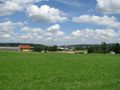
The hash lay on a field in Volkmarsen.
Participants
Plans
Hitchhiking and walking.
Expedition
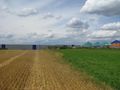
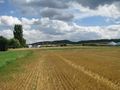
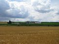
I left home at 9:15 and started to hitchhike at 10 o'clock. I arrived at Volkmarsen at noon. I walked to the hash and found it on a harvested oat field. On the field I found a dead velocicopter too. Then I walked around Volkmarsen and hitchhiked home.
Photos
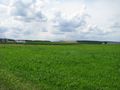
the hash is near
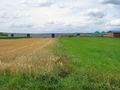
the hashfield
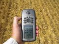
proof
west
north, and the church of Volkmarsen
east
south
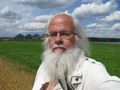
the geohasher
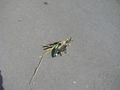
the dead velocicopter


Achievements
GeorgDerReisende earned the Thumbs Up Geohash Achievement
|
GeorgDerReisende earned the GeoTrash Geohash Achievement
|