Difference between revisions of "2016-08-01 51 6"
imported>Pah (create report) |
imported>FippeBot m (Location) |
||
| (4 intermediate revisions by one other user not shown) | |||
| Line 1: | Line 1: | ||
| − | |||
| − | |||
| − | |||
| − | |||
| − | |||
| − | |||
| − | |||
| − | |||
| − | |||
{{meetup graticule | {{meetup graticule | ||
| lat=51 | | lat=51 | ||
| Line 15: | Line 6: | ||
}} | }} | ||
| − | |||
__NOTOC__ | __NOTOC__ | ||
== Location == | == Location == | ||
| − | + | ||
| + | On a harvested and dunged field in [[wikipedia:Düsseldorf|Düsseldorf]] ([[wikipedia:Kaiserswerth|Kaiserswerth]]). | ||
== Participants == | == Participants == | ||
| − | + | ||
| − | -- | + | * [[User:Pah|pah]] [[File:U+110DB.png|middle|6px|link=User:Pah]] ([[2016-05-21 23 -82|prev]]|[[2016-08-02 51 6|next]]) |
== Plans == | == Plans == | ||
| − | + | ||
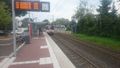
| + | Today's hash is very close to my daily commute path, just five urban railway stations away from work. | ||
| + | Plan: Jump off the train on my way home, take some pictures and enjoy the easy success! | ||
== Expedition == | == Expedition == | ||
| − | |||
| − | + | From the train station "Alte Landstraße" (old country road), the hash is less the 400 meters away on a field. After jumping off the train, it took me less then 10 minutes to walk to the field. The field turned out to be partly dunged by what looked like horse poo, so it smelled quite like countryside, too. | |
| − | + | ||
| + | The hash lies at the opposite side of the field, close to a fenced meadow. How lucky, that it was on "my" side of the fence! After taking some pictures, blessing the hash with some of my sacred coffee and collecting proof, I went back to take one of the next trains to go home. The whole extra trip took about half an hour in total, which to me sounds like a well-deserved [[Easy Geohash]]. | ||
== Photos == | == Photos == | ||
| − | |||
| − | |||
| − | |||
<gallery perrow="5"> | <gallery perrow="5"> | ||
| + | Image:2016-08-01_51_6_pah_001.jpg | Hashbug | ||
| + | Image:2016-08-01_51_6_pah_002.png | Detour at a glance | ||
| + | Image:2016-08-01_51_6_pah_003.jpg | Off the tram | ||
| + | Image:2016-08-01_51_6_pah_004.jpg | View towards the hash | ||
| + | Image:2016-08-01_51_6_pah_005.jpg | Close to the fence | ||
| + | Image:2016-08-01_51_6_pah_006.jpg | View back | ||
| + | Image:2016-08-01_51_6_pah_007.png | Proof #1 | ||
| + | Image:2016-08-01_51_6_pah_008.png | Proof #2 | ||
| + | Image:2016-08-01_51_6_pah_009.jpg | Coffee'n feet | ||
| + | Image:2016-08-01_51_6_pah_010.jpg | [[:Category:Grins|Stupid Grin™]] | ||
| + | Image:2016-08-01_51_6_pah_011.jpg | Going home | ||
</gallery> | </gallery> | ||
== Achievements == | == Achievements == | ||
{{#vardefine:ribbonwidth|800px}} | {{#vardefine:ribbonwidth|800px}} | ||
| − | |||
| − | + | {{Easy_geohash | |
| − | |||
| − | |||
| − | + | | latitude = 51 | |
| + | | longitude = 6 | ||
| + | | date = 2016-08-01 | ||
| + | | name = [[User:Pah|pah]] [[File:U+110DB.png|middle|6px|link=User:Pah]] | ||
| + | | image = 2016-08-01_51_6_pah_002.png | ||
| + | }} | ||
| + | {{Public transport geohash | ||
| + | | latitude = 51 | ||
| + | | longitude = 6 | ||
| + | | date = 2016-08-01 | ||
| + | | busline = U79 | ||
| + | | name = [[User:Pah|pah]] [[File:U+110DB.png|middle|6px|link=User:Pah]] | ||
| + | | image = 2016-08-01 51 6 pah 011.jpg | ||
| − | + | }} | |
| − | + | {{Last man standing | |
| − | [[ | + | | latitude = 51 |
| − | + | | longitude = 6 | |
| + | | date = 2016-08-01 | ||
| + | | name = [[User:Pah|pah]] [[File:U+110DB.png|middle|6px|link=User:Pah]] | ||
| + | }} | ||
| − | |||
| − | |||
[[Category:Expeditions]] | [[Category:Expeditions]] | ||
| − | |||
[[Category:Expeditions with photos]] | [[Category:Expeditions with photos]] | ||
| − | |||
| − | |||
| − | |||
| − | |||
| − | |||
[[Category:Coordinates reached]] | [[Category:Coordinates reached]] | ||
| − | + | {{location|DE|NW|D}} | |
| − | |||
| − | |||
| − | |||
| − | |||
| − | |||
| − | |||
| − | |||
| − | |||
| − | |||
| − | |||
| − | |||
| − | |||
| − | |||
| − | |||
| − | |||
| − | |||
| − | |||
Latest revision as of 01:08, 16 August 2019
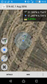
| Mon 1 Aug 2016 in 51,6: 51.2888062, 6.7339405 geohashing.info google osm bing/os kml crox |
Location
On a harvested and dunged field in Düsseldorf (Kaiserswerth).
Participants
Plans
Today's hash is very close to my daily commute path, just five urban railway stations away from work. Plan: Jump off the train on my way home, take some pictures and enjoy the easy success!
Expedition
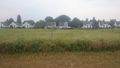
From the train station "Alte Landstraße" (old country road), the hash is less the 400 meters away on a field. After jumping off the train, it took me less then 10 minutes to walk to the field. The field turned out to be partly dunged by what looked like horse poo, so it smelled quite like countryside, too.
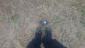
The hash lies at the opposite side of the field, close to a fenced meadow. How lucky, that it was on "my" side of the fence! After taking some pictures, blessing the hash with some of my sacred coffee and collecting proof, I went back to take one of the next trains to go home. The whole extra trip took about half an hour in total, which to me sounds like a well-deserved Easy Geohash.
Photos
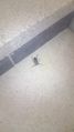
Hashbug
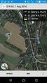
Detour at a glance
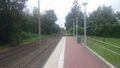
Off the tram
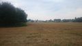
View towards the hash
Close to the fence
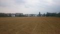
View back
Proof #1

Proof #2
Coffee'n feet
Going home


Achievements
pah
|
pah
|
pah
|