Difference between revisions of "2016-08-06 -13 131"
imported>Felix Dance (An expedition message sent via Geohash Droid for Android.) |
m (Location correction) |
||
| (9 intermediate revisions by 4 users not shown) | |||
| Line 1: | Line 1: | ||
| − | |||
| − | |||
| − | |||
| − | |||
| − | |||
| − | |||
| − | |||
| − | |||
| − | |||
{{meetup graticule | {{meetup graticule | ||
| lat=-13 | | lat=-13 | ||
| Line 15: | Line 6: | ||
}} | }} | ||
| − | + | ||
__NOTOC__ | __NOTOC__ | ||
== Location == | == Location == | ||
| − | + | ||
| + | In the bush next the Ghan Railway line, near Hayes Creek, south of Darwin. | ||
== Participants == | == Participants == | ||
| − | + | * [[User:Felix Dance|Felix Dance]] | |
| − | |||
| − | == | + | == Expedition == |
| − | + | I'm on this long 2500km ride from Darwin to Cairns, and I was only on day 3 when I got into reception to check the geohashes. Bingo, 20kms Away, right on the service track for the Great Ghan Railway Northern Australia Route Awesome. | |
| − | + | Spending about 2 seconds wondering if riding off for this one was really the right thing to do before quickly realising that it'd be a betrayal of everything I held dear to not do it, off I went. | |
| − | + | ||
| + | The problem was water. My meticulous planning had me running out of water 5 kms prior to reaching an old campsite which should have some. Adding about 10 kms to my route wasn't going to be nice, particularly as 10kms is over an hour on these roads. | ||
| + | |||
| + | Anyway, I rode off the main road into a gold mining region and then onto the 'No Entry' Railway service road. | ||
| + | |||
| + | Awful road: Full of corrugations, creek crossings, overgrown vegetation and ridiculous boulders. At one point I scared a herd of bulls and they destroyed their fence escaping from me and ran over the railway tracks (luckily, no train). | ||
| + | |||
| + | At last I arrived. I clambered under a barbed wire fence on the other side of the tracks and shooed away a bunch of wallabies. Took photos, headed back. It was a long, long ride to the campsite. | ||
| − | + | But I got there. Just as I was rationing the last sips of water by storing them in my mouth. And, as it turned out, I happened to turn up on the night of free camping, a massive free BBQ and at the same time as a bus load of five touring bands from Melbourne had arrived to put on a massive show. What a geohashing finale! | |
| − | |||
== Photos == | == Photos == | ||
| − | + | ||
| − | |||
| − | |||
<gallery perrow="5"> | <gallery perrow="5"> | ||
| + | |||
| + | Image:2016-08-06_-13_131_Felix Dance_1470461000510.jpg|Ghan Railway success! [http://www.openstreetmap.org/?lat=-13.45308940&lon=131.39316250&zoom=16&layers=B000FTF @-13.4531,131.3932] | ||
| + | |||
| + | Image:20160806145010 Bike.JPG|My bike near the hash | ||
| + | |||
| + | Image:20160806145015 Tracks.JPG|The fabled Ghan Railway | ||
</gallery> | </gallery> | ||
== Achievements == | == Achievements == | ||
{{#vardefine:ribbonwidth|800px}} | {{#vardefine:ribbonwidth|800px}} | ||
| − | |||
| − | |||
| − | |||
| − | |||
| − | + | {{Land geohash | |
| − | + | | latitude = -13 | |
| − | + | | longitude = 131 | |
| − | [[ | + | | date = 2016-08-06 |
| − | + | | name = [[User:Felix Dance|Felix Dance]] | |
| + | | image = 20160806145010 Bike.JPG | ||
| + | }} | ||
| − | + | {{bicycle geohash | |
| + | |||
| + | | latitude = -13 | ||
| + | | longitude = 131 | ||
| + | | date = 2016-08-06 | ||
| + | | name = [[User:Felix Dance|Felix Dance]] | ||
| + | | distance = about 10kms extra, 65kms for the day | ||
| + | | bothways = true | ||
| + | | image = 20160806145010 Bike.JPG | ||
| + | }} | ||
| − | |||
[[Category:Expeditions]] | [[Category:Expeditions]] | ||
| − | |||
[[Category:Expeditions with photos]] | [[Category:Expeditions with photos]] | ||
| − | |||
| − | |||
| − | |||
| − | |||
| − | |||
[[Category:Coordinates reached]] | [[Category:Coordinates reached]] | ||
| − | + | {{location|AU|NT|TE}} | |
| − | |||
| − | |||
| − | |||
| − | |||
| − | |||
| − | |||
| − | |||
| − | |||
| − | |||
| − | |||
| − | |||
| − | |||
| − | |||
| − | |||
| − | |||
| − | |||
| − | |||
Latest revision as of 14:33, 4 October 2020
| Sat 6 Aug 2016 in -13,131: -13.4530916, 131.3931888 geohashing.info google osm bing/os kml crox |
Location
In the bush next the Ghan Railway line, near Hayes Creek, south of Darwin.
Participants
Expedition
I'm on this long 2500km ride from Darwin to Cairns, and I was only on day 3 when I got into reception to check the geohashes. Bingo, 20kms Away, right on the service track for the Great Ghan Railway Northern Australia Route Awesome.
Spending about 2 seconds wondering if riding off for this one was really the right thing to do before quickly realising that it'd be a betrayal of everything I held dear to not do it, off I went.
The problem was water. My meticulous planning had me running out of water 5 kms prior to reaching an old campsite which should have some. Adding about 10 kms to my route wasn't going to be nice, particularly as 10kms is over an hour on these roads.
Anyway, I rode off the main road into a gold mining region and then onto the 'No Entry' Railway service road.
Awful road: Full of corrugations, creek crossings, overgrown vegetation and ridiculous boulders. At one point I scared a herd of bulls and they destroyed their fence escaping from me and ran over the railway tracks (luckily, no train).
At last I arrived. I clambered under a barbed wire fence on the other side of the tracks and shooed away a bunch of wallabies. Took photos, headed back. It was a long, long ride to the campsite.
But I got there. Just as I was rationing the last sips of water by storing them in my mouth. And, as it turned out, I happened to turn up on the night of free camping, a massive free BBQ and at the same time as a bus load of five touring bands from Melbourne had arrived to put on a massive show. What a geohashing finale!
Photos
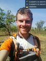
Ghan Railway success! @-13.4531,131.3932
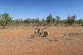
My bike near the hash
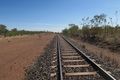
The fabled Ghan Railway


Achievements
Felix Dance earned the Land geohash achievement
|
Felix Dance earned the Bicycle geohash achievement
|