Difference between revisions of "2016-08-14 52 1"
From Geohashing
imported>Sourcerer m (→Achievements) |
imported>Sourcerer m ([live picture] Midnight. [http://www.openstreetmap.org/?lat=52.14332342&lon=1.11057401&zoom=16&layers=B000FTF @52.1433,1.1106]) |
||
| Line 27: | Line 27: | ||
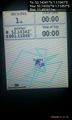
Image:2016-08-14_52_1_Sourcerer_1471128546701.jpg | Arrived early. [http://www.openstreetmap.org/?lat=52.14340925&lon=1.11048281&zoom=16&layers=B000FTF @52.1434,1.1105] | Image:2016-08-14_52_1_Sourcerer_1471128546701.jpg | Arrived early. [http://www.openstreetmap.org/?lat=52.14340925&lon=1.11048281&zoom=16&layers=B000FTF @52.1434,1.1105] | ||
| + | |||
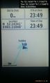
| + | Image:2016-08-14_52_1_Sourcerer_1471129151198.jpg | Midnight. [http://www.openstreetmap.org/?lat=52.14332342&lon=1.11057401&zoom=16&layers=B000FTF @52.1433,1.1106] | ||
</gallery> | </gallery> | ||
Revision as of 23:01, 13 August 2016
| Sun 14 Aug 2016 in Norwich, UK: 52.1434052, 1.1104725 geohashing.info google osm bing/os kml crox |
Location
Under a tree on a public footpath at Coddenham, Suffolk, UK.
Participants
Plans
Two of two spanning midnight - 2016-08-13 52 1 - 2016-08-14 52 1 - ETA 23:15.
Expedition
Photos
- Photo Gallery
Arrived early. @52.1434,1.1105
Midnight. @52.1433,1.1106


Achievements
Sourcerer earned the Midnight Geohash achievement
|
Expeditions and Plans
| 2016-08-14 | ||
|---|---|---|
| Passau, Germany | Q-Owl, Q-Owla | Between Uttendorf and Mattighofen, Austria. |
| Norwich, United Kingdom | Sourcerer | Under a tree on a public footpath at Coddenham, Suffolk, UK. |
Sourcerer's Expedition Links
2016-08-13 52 1 - 2016-08-14 52 1 - 2016-08-15 52 1 - KML file download of Sourcerer's expeditions for use with Google Earth.