Difference between revisions of "2016-08-20 52 5"
imported>FelixTheCat |
imported>FippeBot m (Location) |
||
| (2 intermediate revisions by one other user not shown) | |||
| Line 12: | Line 12: | ||
== Expedition == | == Expedition == | ||
| − | Today looked like a nice day to hash. The weather was nice, and today's location was in a residential area of the city of Baarn. I thought it would be interesting to visit a hash in a built-up area for a change, since I usually hash in forests and fields. So off to Baarn I went and found the location pretty quickly. It was located in a park-like area between two rows of houses. I took a few pictures and then explored the area a bit. About 1 km to the south there was a monument to the [https://en.wikipedia.org/wiki/Battle_of_Quatre_Bras | + | Today looked like a nice day to hash. The weather was nice, and today's location was in a residential area of the city of Baarn. I thought it would be interesting to visit a hash in a built-up area for a change, since I usually hash in forests and fields. So off to Baarn I went and found the location pretty quickly. It was located in a park-like area between two rows of houses. I took a few pictures and then explored the area a bit. About 1 km to the south there was a monument to the 1815 [https://en.wikipedia.org/wiki/Battle_of_Quatre_Bras Battle of Quatre Bras], in which the British-Dutch-Prussian alliance managed to defeat the French near Brussels, paving the way to Napoleon's defeat at Waterloo. |
== Photos == | == Photos == | ||
| Line 25: | Line 25: | ||
== Achievements == | == Achievements == | ||
{{#vardefine:ribbonwidth|800px}} | {{#vardefine:ribbonwidth|800px}} | ||
| − | {{ | + | {{Two to the N achievement |
| + | | count = 4 | ||
| + | | date = 2016-08-20 | ||
| latitude = 52 | | latitude = 52 | ||
| longitude = 5 | | longitude = 5 | ||
| − | |||
| name = [[User:FelixTheCat|FelixTheCat]] ([[User talk:FelixTheCat|talk]]) | | name = [[User:FelixTheCat|FelixTheCat]] ([[User talk:FelixTheCat|talk]]) | ||
| − | }} | + | | reached = true |
| + | }} | ||
[[Category:Expeditions]] | [[Category:Expeditions]] | ||
[[Category:Expeditions with photos]] | [[Category:Expeditions with photos]] | ||
[[Category:Coordinates reached]] | [[Category:Coordinates reached]] | ||
| + | {{location|NL|UT}} | ||
Latest revision as of 01:16, 16 August 2019
| Sat 20 Aug 2016 in 52,5: 52.2013648, 5.2970473 geohashing.info google osm bing/os kml crox |
Location
A residential area in Baarn.
Participants
Expedition
Today looked like a nice day to hash. The weather was nice, and today's location was in a residential area of the city of Baarn. I thought it would be interesting to visit a hash in a built-up area for a change, since I usually hash in forests and fields. So off to Baarn I went and found the location pretty quickly. It was located in a park-like area between two rows of houses. I took a few pictures and then explored the area a bit. About 1 km to the south there was a monument to the 1815 Battle of Quatre Bras, in which the British-Dutch-Prussian alliance managed to defeat the French near Brussels, paving the way to Napoleon's defeat at Waterloo.
Photos
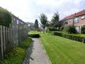
The hash is somewhere in the hedge up ahead.
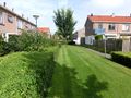
Somewhere around where I'm standing right now, that is.
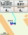
A bit tricky to get a low enough reading, but this should qualify...
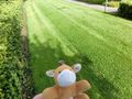
Lloyd posing at the hedge.
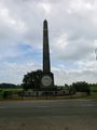
The monument.


Achievements
