Difference between revisions of "2016-08-27 47 -122"
imported>Jiml m (Appease APBot) |
imported>Thomcat (Added success category) |
||
| Line 1: | Line 1: | ||
| − | |||
| − | |||
| − | |||
| − | |||
| − | |||
| − | |||
| − | |||
| − | |||
| − | |||
| − | |||
{{meetup graticule | {{meetup graticule | ||
| lat=47 | | lat=47 | ||
| lon=-122 | | lon=-122 | ||
| date=2016-08-27 | | date=2016-08-27 | ||
| + | | graticule_name=Seattle | ||
| + | | graticule_link=Seattle, Washington | ||
}} | }} | ||
| − | |||
<!-- edit as necessary --> | <!-- edit as necessary --> | ||
__NOTOC__ | __NOTOC__ | ||
== Location == | == Location == | ||
| − | + | In Lincoln park, West Seattle, between three different paths. | |
| − | |||
| − | |||
== Participants == | == Participants == | ||
| − | + | * [[User:Thomcat|Thomcat]] | |
| − | * Thomcat | ||
* [[User:Zebburkeconte|Zebburkeconte]] and | * [[User:Zebburkeconte|Zebburkeconte]] and | ||
* dad, | * dad, | ||
| Line 35: | Line 23: | ||
== Expedition == | == Expedition == | ||
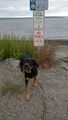
| − | + | [[User:Thomcat|Thomcat]] went unannounced in the morning with the dog, being an excellent day for walking said companion. Yes, West Seattle is a little further than the neighborhood park around the corner, but there was a geohash to be had! Also, previous thoughts of visiting said geohash with the family around 4pm had fallen through. | |
| + | |||
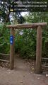
| + | We walked along the path, snapping pictures and sniffing and staring at abundant squirrels. Many of the wild spaces between paths are eminently crossable, but the geohash area proved to be a bit wilder than that. | ||
| + | |||
| + | Still, following the lead of my faithful companion, I went gently into that good undergrowth. Probably saved the [[User:Zebburkeconte|Zebburkeconte]] family from a few spider bites by knocking them all down :) Trees caused a lot more geohash dance than usual. After a bit of back and forth and around said trees, we found the spot and uploaded appropriate pictures. | ||
| + | |||
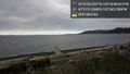
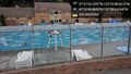
| + | We then returned to the path and continued on to one of Seattle's outdoor swimming pools, situated right next to the beach and the Puget Sound. Looping south past the ferry dock, we returned to the car and a trip north - where the rest of the family was still fast asleep. | ||
| + | |||
== Tracklog == | == Tracklog == | ||
| Line 85: | Line 80: | ||
<!-- Add any achievement ribbons you earned below, or remove this section --> | <!-- Add any achievement ribbons you earned below, or remove this section --> | ||
| − | |||
| − | |||
| − | |||
| − | |||
| − | |||
| − | |||
| − | |||
| − | |||
| − | |||
[[Category:Expeditions]] | [[Category:Expeditions]] | ||
[[Category:Expeditions with photos]] | [[Category:Expeditions with photos]] | ||
| − | |||
| − | |||
| − | |||
[[Category:Coordinates reached]] | [[Category:Coordinates reached]] | ||
| − | |||
| − | |||
| − | |||
| − | |||
| − | |||
| − | |||
| − | |||
| − | |||
| − | |||
| − | |||
| − | |||
| − | |||
| − | |||
| − | |||
| − | |||
| − | |||
| − | |||
| − | |||
Revision as of 04:51, 29 August 2016
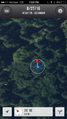
| Sat 27 Aug 2016 in Seattle: 47.5311749, -122.3968392 geohashing.info google osm bing/os kml crox |
Location
In Lincoln park, West Seattle, between three different paths.
Participants
- Thomcat
- Zebburkeconte and
- dad,
- dad's wife and
- her kids (6 people in total!)
Plans
Expedition
Thomcat went unannounced in the morning with the dog, being an excellent day for walking said companion. Yes, West Seattle is a little further than the neighborhood park around the corner, but there was a geohash to be had! Also, previous thoughts of visiting said geohash with the family around 4pm had fallen through.
We walked along the path, snapping pictures and sniffing and staring at abundant squirrels. Many of the wild spaces between paths are eminently crossable, but the geohash area proved to be a bit wilder than that.
Still, following the lead of my faithful companion, I went gently into that good undergrowth. Probably saved the Zebburkeconte family from a few spider bites by knocking them all down :) Trees caused a lot more geohash dance than usual. After a bit of back and forth and around said trees, we found the spot and uploaded appropriate pictures.
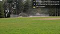
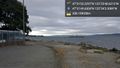
We then returned to the path and continued on to one of Seattle's outdoor swimming pools, situated right next to the beach and the Puget Sound. Looping south past the ferry dock, we returned to the car and a trip north - where the rest of the family was still fast asleep.
Tracklog
Photos
Thomcat
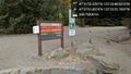
Almost there @47.5311,-122.3933
Dragging the diamond @47.5328,-122.3946
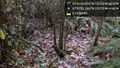
Lots of brush & webs @47.5311,-122.3968

Geohasher @47.5311,-122.3969

Lots of trees too @47.5312,-122.3969
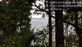
View of the sound @47.5310,-122.3987
Beach trail @47.5297,-122.3990
Beach @47.5308,-122.4011
Swimmin @47.5305,-122.4013
No dogs
Ferry @47.5305,-122.4015


zebburkeconte
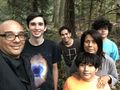
There were a bunch of us
Right on top of it! (This is from my dad's phone, mine never looked quite this good)

