Difference between revisions of "2016-09-16 49 8"
imported>Rincewind (→Photos) |
imported>FippeBot m (Location) |
||
| (6 intermediate revisions by 2 users not shown) | |||
| Line 1: | Line 1: | ||
| − | |||
| − | |||
| − | |||
| − | |||
| − | |||
| − | |||
| − | |||
| − | |||
| − | |||
{{meetup graticule | {{meetup graticule | ||
| lat=49 | | lat=49 | ||
| Line 15: | Line 6: | ||
}} | }} | ||
| − | |||
__NOTOC__ | __NOTOC__ | ||
== Location == | == Location == | ||
At the very edge of a small lake near Dieburg. | At the very edge of a small lake near Dieburg. | ||
| + | |||
This is a popular area for barbecues and letting the kids roam to play soccer or do other outdoor activities. | This is a popular area for barbecues and letting the kids roam to play soccer or do other outdoor activities. | ||
== Participants == | == Participants == | ||
| − | + | * [[User:Yakamoz|Yakamoz]] and | |
| − | + | * [[User:Rincewind|Rincewind]] | |
== Plans == | == Plans == | ||
| Line 32: | Line 23: | ||
== Expedition == | == Expedition == | ||
We drove there following satnav and just walked a hundred meters or so from the recreation area's parking spaces along the road. | We drove there following satnav and just walked a hundred meters or so from the recreation area's parking spaces along the road. | ||
| − | The | + | |
| + | The hashpoint was straight ahead, just at the very edge of the lake. | ||
Rincewind got a "1m shot" on the Garmin and didn't want to step further in the weed and bushes for fear of taking an unexpected bath. Those weeds proved to be experts at clinging their seed to trousers and other clothes... | Rincewind got a "1m shot" on the Garmin and didn't want to step further in the weed and bushes for fear of taking an unexpected bath. Those weeds proved to be experts at clinging their seed to trousers and other clothes... | ||
After a long time, hash success, again! :) | After a long time, hash success, again! :) | ||
| − | |||
| − | |||
== Photos == | == Photos == | ||
| − | + | ||
| − | |||
| − | |||
<gallery perrow="5"> | <gallery perrow="5"> | ||
Image:2016-09-16_49_8_Rincewind_1474050185693.jpg|an idyllic geohash point | Image:2016-09-16_49_8_Rincewind_1474050185693.jpg|an idyllic geohash point | ||
| − | |||
Image:2016-09-16_49_8_Rincewind_1474050448826.jpg|coordinates reached | Image:2016-09-16_49_8_Rincewind_1474050448826.jpg|coordinates reached | ||
| − | |||
Image:2016-09-16_49_8_Rincewind_1474050472153.jpg|stupid grin | Image:2016-09-16_49_8_Rincewind_1474050472153.jpg|stupid grin | ||
| − | |||
Image:2016-09-16_49_8_Rincewind_1474050505522.jpg|another view | Image:2016-09-16_49_8_Rincewind_1474050505522.jpg|another view | ||
Image:2016-09-16_49_8 hashproof.jpg|Screenshots from the GPS thingy... | Image:2016-09-16_49_8 hashproof.jpg|Screenshots from the GPS thingy... | ||
| Line 60: | Line 45: | ||
== Achievements == | == Achievements == | ||
{{#vardefine:ribbonwidth|800px}} | {{#vardefine:ribbonwidth|800px}} | ||
| − | |||
| − | + | {{land geohash | |
| − | + | | latitude = 49 | |
| − | [[ | + | | longitude = 8 |
| + | | date = 2016-09-16 | ||
| + | | name = [[User:Yakamoz|Yakamoz]] and [[User:Rincewind|Rincewind]] | ||
| + | }} | ||
| + | |||
| + | {{Easy_geohash | ||
| − | + | | latitude = 49 | |
| + | | longitude = 8 | ||
| + | | date = 2016-09-16 | ||
| + | | name = [[User:Yakamoz|Yakamoz]] and [[User:Rincewind|Rincewind]] | ||
| + | }} | ||
| − | |||
| − | |||
| − | |||
| − | |||
| − | |||
| − | |||
| − | |||
| − | |||
[[Category:Expeditions]] | [[Category:Expeditions]] | ||
| − | |||
[[Category:Expeditions with photos]] | [[Category:Expeditions with photos]] | ||
| − | |||
| − | |||
| − | |||
| − | |||
| − | |||
[[Category:Coordinates reached]] | [[Category:Coordinates reached]] | ||
| − | + | {{location|DE|HE|DA}} | |
| − | |||
| − | |||
| − | |||
| − | |||
| − | |||
| − | |||
| − | |||
| − | |||
| − | |||
| − | |||
| − | |||
| − | |||
| − | |||
| − | |||
| − | |||
| − | |||
| − | |||
Latest revision as of 01:28, 16 August 2019
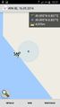
| Fri 16 Sep 2016 in 49,8: 49.8950078, 8.8069499 geohashing.info google osm bing/os kml crox |
Location
At the very edge of a small lake near Dieburg.
This is a popular area for barbecues and letting the kids roam to play soccer or do other outdoor activities.
Participants
Plans
Rincewind and Yakamoz actually met in front of their flat when coming home and decided to go hashing, since Rincewind had an alarm going off in his Geohash Droid (Thanks, Nicholas) that the hash coordinates were near home. The plan was to go there and not be in water...
Expedition
We drove there following satnav and just walked a hundred meters or so from the recreation area's parking spaces along the road.
The hashpoint was straight ahead, just at the very edge of the lake. Rincewind got a "1m shot" on the Garmin and didn't want to step further in the weed and bushes for fear of taking an unexpected bath. Those weeds proved to be experts at clinging their seed to trousers and other clothes...
After a long time, hash success, again! :)
Photos
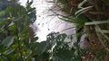
an idyllic geohash point
coordinates reached

stupid grin
another view
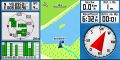
Screenshots from the GPS thingy...
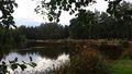
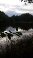
View over the hashpoint and the side of the lake towards the recreation area


Achievements
Yakamoz and Rincewind earned the Land geohash achievement
|
Yakamoz and Rincewind has visited an Easy Geohash
|