Difference between revisions of "2016-10-02 52 1"
From Geohashing
imported>Sourcerer m (→Planning) |
imported>FippeBot m (Location) |
||
| Line 42: | Line 42: | ||
[[Category:Expeditions with photos]] | [[Category:Expeditions with photos]] | ||
[[Category:Coordinates reached]] | [[Category:Coordinates reached]] | ||
| + | {{location|GB|ENG|SFK}} | ||
Latest revision as of 01:34, 16 August 2019
| Sun 2 Oct 2016 in Norwich, UK: 52.3241238, 1.3752673 geohashing.info google osm bing/os kml crox |
Location
A field between Swan Green and Cratfield, Suffolk, UK.
Participants
Plans
No plan as such. I set out after completing the chores of the day.
Expedition
There was field-side parking 100 metres from the hashpoint which was about 40 metres into a ploughed field. The moon had set and the stars were bright including the milky way, not often seen due to light pollution.
Photos
- Photo Gallery
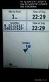
Arrived. @52.3241,1.3753
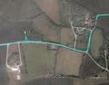
Google Earth Track


Achievements
Expeditions and Plans
| 2016-10-02 | ||
|---|---|---|
| Mannheim, Germany | DODO | The forest near Dudenhofen, just 3,5 kilometers from DODOs home. |
| Kassel, Germany | GeorgDerReisende | The hash lay on a meadow north of the Kastanienallee in Kassel. |
| Norwich, United Kingdom | Sourcerer | A field between Swan Green and Cratfield, Suffolk, UK. |
Sourcerer's Expedition Links
2016-09-21 52 1 - 2016-10-02 52 1 - 2016-10-20 52 1 - KML file download of Sourcerer's expeditions for use with Google Earth.