Difference between revisions of "2016-11-01 52 5"
From Geohashing
imported>JwB m (→Expedition) |
imported>FippeBot m (Location) |
||
| (4 intermediate revisions by 2 users not shown) | |||
| Line 33: | Line 33: | ||
<!-- if your GPS device keeps a log, you may post a link here --> | <!-- if your GPS device keeps a log, you may post a link here --> | ||
| − | == Photos == | + | == Photos == |
| − | + | ||
| − | |||
| − | |||
<gallery perrow="5"> | <gallery perrow="5"> | ||
| + | Image: Proof161101.png | there | ||
| + | Image: IMG_20161101_085136455.jpg | parking lot | ||
</gallery> | </gallery> | ||
== Achievements == | == Achievements == | ||
{{#vardefine:ribbonwidth|800px}} | {{#vardefine:ribbonwidth|800px}} | ||
| − | |||
| − | |||
| − | |||
| − | |||
| − | |||
| − | |||
| − | |||
| − | + | {{bicycle geohash | |
| − | + | | latitude = 52 | |
| − | + | | longitude = 5 | |
| − | + | | date = 2016-11-01 | |
| + | | name = JwB | ||
| + | | distance = 15 km | ||
| + | | bothways = false | ||
| + | }} | ||
| − | + | {{Tron | |
| + | | latitude = 52 | ||
| + | | longitude = 5 | ||
| + | | date = 2016-11-01 | ||
| + | | tracklog = | ||
| + | | possessive = his | ||
| + | | name = JwB | ||
| + | }} | ||
| − | |||
[[Category:Expeditions]] | [[Category:Expeditions]] | ||
| − | |||
[[Category:Expeditions with photos]] | [[Category:Expeditions with photos]] | ||
| − | |||
| − | |||
| − | |||
| − | |||
| − | |||
[[Category:Coordinates reached]] | [[Category:Coordinates reached]] | ||
| − | + | {{location|NL|UT}} | |
| − | |||
| − | |||
| − | |||
| − | |||
| − | |||
| − | |||
| − | |||
| − | |||
| − | |||
| − | |||
| − | |||
| − | |||
| − | |||
| − | |||
| − | |||
| − | |||
| − | |||
Latest revision as of 18:16, 26 July 2019
| Tue 1 Nov 2016 in 52,5: 52.1286985, 5.0322144 geohashing.info google osm bing/os kml crox |
Location
Parking lot in a residential area in Maarssenboek
Participants
Plans
As I had to pick up some stuff quite near, I might as well detour on my way back home and cycle a few km more.
Expedition
Went as should have. Nice wheather, nice bikepath, nice ride. Easily found the spot, and as I had not yet crossed my tracks, detoured such that I made a Tron of the trip.
Tracklog
Photos
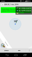
there
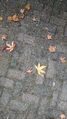
parking lot


Achievements
JwB earned the Bicycle geohash achievement
|
JwB earned the Tron achievement
|