Difference between revisions of "2016-11-22 48 9"
From Geohashing
imported>RecentlyChanged (First write up of my girlfriends first autonomous hash (more in the discussion)) |
m (→Participants) |
||
| (3 intermediate revisions by 2 users not shown) | |||
| Line 22: | Line 22: | ||
== Participants == | == Participants == | ||
| − | Miriam | + | *Miriam |
| − | == | + | ==Report== |
| + | She told me, she saw in the Hashdroid App, that the hash was nearby. | ||
| + | She had to go, because it was nearby. | ||
| + | So she took her car and went off into the dark. | ||
| + | (It was only around 5pm, but getting dark at least.) | ||
| + | |||
| + | With her car she got the distance to the hash down to about 50 meters. | ||
| + | Then she had to leave the car and walk into the forest. | ||
| + | She even saw a fox when leaving the car. | ||
| + | And it was a little bit scary. | ||
| + | But she did it. | ||
| + | She only remembered to take a screenshot as proof, but not the selfie. | ||
| + | |||
| + | |||
| + | I was surprised! | ||
| + | |||
| + | |||
| + | (She showed no interest at all in writing up her story, so I recalled it just now [[User:RecentlyChanged|RecentlyChanged]] ([[User_talk:RecentlyChanged|talk]]) 17:37, 5 January 2017 (UTC)) | ||
| − | |||
| − | |||
| Line 41: | Line 56: | ||
== Achievements == | == Achievements == | ||
{{#vardefine:ribbonwidth|800px}} | {{#vardefine:ribbonwidth|800px}} | ||
| − | + | {{land geohash | |
| + | | latitude = 48 | ||
| + | | longitude = 9 | ||
| + | | date = 2016-11-22 | ||
| + | }} | ||
| + | {{Minesweeper geohash | ||
| + | |||
| + | | graticule = Pforzheim, Germany | ||
| + | | ranknumber = 1 | ||
| + | | e = true if graticule to the east has been hashed (optional) | ||
| + | |||
| + | }} | ||
| + | {{Two to the N achievement | ||
| + | | count = 2 | ||
| + | | date = 2016-11-22 | ||
| + | | latitude = 48 | ||
| + | | longitude = 9 | ||
| + | }} | ||
[[Category:Expeditions]] | [[Category:Expeditions]] | ||
[[Category:Coordinates reached]] | [[Category:Coordinates reached]] | ||
| + | {{location|DE|BW|BC}} | ||
Latest revision as of 17:16, 1 June 2023
| Tue 22 Nov 2016 in 48,9: 48.1134004, 9.6958209 geohashing.info google osm bing/os kml crox |
Location
In the forest.
Participants
- Miriam
Report
She told me, she saw in the Hashdroid App, that the hash was nearby. She had to go, because it was nearby. So she took her car and went off into the dark. (It was only around 5pm, but getting dark at least.)
With her car she got the distance to the hash down to about 50 meters. Then she had to leave the car and walk into the forest. She even saw a fox when leaving the car. And it was a little bit scary. But she did it. She only remembered to take a screenshot as proof, but not the selfie.
I was surprised!
(She showed no interest at all in writing up her story, so I recalled it just now RecentlyChanged (talk) 17:37, 5 January 2017 (UTC))
Photos
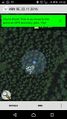
Screenshot of the map
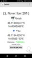
Screenshot of the coordinates


Achievements
This user earned the Land geohash achievement
|
This user achieved level 1 of the Minesweeper Geohash achievement
|

This user earned the Two to the N achievement
by attempting to reach 22 hashpoints on 2016-11-22 48 9 and is promoted to Level 2 (Expeditions).