Difference between revisions of "2016-11-24 52 1"
From Geohashing
imported>Sourcerer m ([live picture] Arrived. [http://www.openstreetmap.org/?lat=52.25638390&lon=1.10881448&zoom=16&layers=B000FTF @52.2564,1.1088]) |
imported>Sourcerer m (→New expedition) |
||
| Line 21: | Line 21: | ||
== Expedition == | == Expedition == | ||
| + | Very easy - empty main roads led close to the hashpoint. A combination of a public footpath and tractor tracks completed the expedition. | ||
== Photos == | == Photos == | ||
<gallery caption="Photo Gallery" perrow="3"> | <gallery caption="Photo Gallery" perrow="3"> | ||
| − | |||
Image:2016-11-24_52_1_Sourcerer_1480026331361.jpg | Arrived. [http://www.openstreetmap.org/?lat=52.25638390&lon=1.10881448&zoom=16&layers=B000FTF @52.2564,1.1088] | Image:2016-11-24_52_1_Sourcerer_1480026331361.jpg | Arrived. [http://www.openstreetmap.org/?lat=52.25638390&lon=1.10881448&zoom=16&layers=B000FTF @52.2564,1.1088] | ||
| + | Image:2016-11-24_52_1_Sourcerer.jpg | Google Earth Track | ||
</gallery> | </gallery> | ||
| Line 38: | Line 39: | ||
}} | }} | ||
| − | |||
| − | |||
[[Category:Expeditions]] | [[Category:Expeditions]] | ||
[[Category:Expeditions with photos]] | [[Category:Expeditions with photos]] | ||
[[Category:Coordinates reached]] | [[Category:Coordinates reached]] | ||
| − | |||
Revision as of 23:18, 24 November 2016
| Thu 24 Nov 2016 in Norwich, UK: 52.2563759, 1.1088294 geohashing.info google osm bing/os kml crox |
Location
A field east of Brockford Street, Suffolk, UK.
Participants
Plans
Go after the Waveney Ramblers AGM.
Expedition
Very easy - empty main roads led close to the hashpoint. A combination of a public footpath and tractor tracks completed the expedition.
Photos
- Photo Gallery
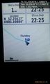
Arrived. @52.2564,1.1088
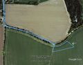
Google Earth Track


Achievements
Expeditions and Plans
| 2016-11-24 | ||
|---|---|---|
| Norwich, United Kingdom | Sourcerer | A field east of Brockford Street, Suffolk, UK. |
Sourcerer's Expedition Links
2016-11-20 52 1 - 2016-11-24 52 1 - 2016-11-26 52 1 - KML file download of Sourcerer's expeditions for use with Google Earth.