Difference between revisions of "2016-11-27 52 1"
imported>Sourcerer m (→Plans) |
imported>FippeBot m (Location) |
||
| (9 intermediate revisions by one other user not shown) | |||
| Line 9: | Line 9: | ||
== Location == | == Location == | ||
| − | A field near Mettingham, Suffolk, UK 600 metres from a retro point. | + | A field near Mettingham, Suffolk, UK, 600 metres from a retro point. |
== Participants == | == Participants == | ||
| Line 17: | Line 17: | ||
== Plans == | == Plans == | ||
| − | + | Four of four spanning midnight. | |
[[2015-09-11 52 1|2015-09-11 52 1 Retro]] - [[2016-11-26 52 1]] - [[2014-02-07 52 1|2014-02-07 52 1 Retro]] - [[2016-11-27 52 1]] - ETA 00:00. | [[2015-09-11 52 1|2015-09-11 52 1 Retro]] - [[2016-11-26 52 1]] - [[2014-02-07 52 1|2014-02-07 52 1 Retro]] - [[2016-11-27 52 1]] - ETA 00:00. | ||
| Line 23: | Line 23: | ||
== Expedition == | == Expedition == | ||
| + | === Midnight === | ||
| + | It was a damp evening with light drizzle. There was a handy parking place. A short trek along the Angles Way with a few orthogonal paces led to the hashpoint. My phone battery was flat, hence the lack of my usual live upload. | ||
| + | |||
| + | === Next morning === | ||
| + | |||
| + | So I had a craving for a pint of Weisen beer and a bacon, brie and cranberry baguette with some exercise thrown in. The weather was good for late November so I set out on an 11.5 mile walk. The hashpoint was about 18 metres off the Angles Way so re-doing the point was a no brainer. I had charged my phone so here's the delayed live upload. | ||
| + | |||
| + | *Arrived again! -- [[User:Sourcerer|Sourcerer]] ([[User talk:Sourcerer|talk]]) [http://www.openstreetmap.org/?lat=52.45448112&lon=1.46554291&zoom=16&layers=B000FTF @52.4545,1.4655] 10:29, 27 November 2016 (GMT) | ||
| + | |||
| + | It was a circular walk so a Tron Achievement was no problem. I limited myself to one pint in the pub in order not to cross my own path. | ||
| + | |||
| + | Now I only wonder why I bothered with the point last midnight? | ||
== Photos == | == Photos == | ||
<gallery caption="Photo Gallery" perrow="3"> | <gallery caption="Photo Gallery" perrow="3"> | ||
| + | Image:2016-11-27 52 1 Sourcerer Track.jpg | Google Earth Track - Midnight | ||
| + | Image:2016-11-27 52 1 Sourcerer Proof.jpg | Proof | ||
| + | Image:2016-11-27_52_1_Sourcerer_1480242603986.jpg | Re-proof. [http://www.openstreetmap.org/?lat=52.45448112&lon=1.46554828&zoom=16&layers=B000FTF @52.4545,1.4655] | ||
| + | Image:2016-11-27_52_1_Sourcerer_1480242567643.jpg | View. [http://www.openstreetmap.org/?lat=52.45448112&lon=1.46554828&zoom=16&layers=B000FTF @52.4545,1.4655] | ||
| + | Image:2016-11-27 52 1 Sourcerer Again.jpg | Google Earth Track - Day time | ||
| + | Image:2016-11-27 52 1 Sourcerer Tron.jpg | Tron Track | ||
</gallery> | </gallery> | ||
== Achievements == | == Achievements == | ||
{{#vardefine:ribbonwidth|800px}} | {{#vardefine:ribbonwidth|800px}} | ||
| + | |||
| + | {{Midnight geohash | ||
| + | | latitude = 52 | ||
| + | | longitude = 1 | ||
| + | | date = 2016-11-27 | ||
| + | | name = Sourcerer | ||
| + | }} | ||
| + | |||
| + | {{Walk geohash | ||
| + | | latitude = 52 | ||
| + | | longitude = 1 | ||
| + | | date = 2016-11-27 | ||
| + | | name = Sourcerer | ||
| + | | distance = 11.5 miles | ||
| + | }} | ||
| + | |||
| + | {{Tron | ||
| + | | latitude = 52 | ||
| + | | longitude = 1 | ||
| + | | date = 2016-11-27 | ||
| + | | name = Sourcerer | ||
| + | | tracklog = http://www.wikiloc.com/wikiloc/view.do?id=15628014 | ||
| + | | possessive = his | ||
| + | }} | ||
{{Sourcerer_links | {{Sourcerer_links | ||
| Line 39: | Line 81: | ||
}} | }} | ||
| − | |||
| − | |||
[[Category:Expeditions]] | [[Category:Expeditions]] | ||
[[Category:Expeditions with photos]] | [[Category:Expeditions with photos]] | ||
[[Category:Coordinates reached]] | [[Category:Coordinates reached]] | ||
| − | + | {{location|GB|ENG|SFK}} | |
Latest revision as of 01:47, 16 August 2019
| Sun 27 Nov 2016 in Norwich, UK: 52.4544855, 1.4655670 geohashing.info google osm bing/os kml crox |
Location
A field near Mettingham, Suffolk, UK, 600 metres from a retro point.
Participants
Plans
Four of four spanning midnight.
2015-09-11 52 1 Retro - 2016-11-26 52 1 - 2014-02-07 52 1 Retro - 2016-11-27 52 1 - ETA 00:00.
Expedition
Midnight
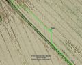
It was a damp evening with light drizzle. There was a handy parking place. A short trek along the Angles Way with a few orthogonal paces led to the hashpoint. My phone battery was flat, hence the lack of my usual live upload.
Next morning
So I had a craving for a pint of Weisen beer and a bacon, brie and cranberry baguette with some exercise thrown in. The weather was good for late November so I set out on an 11.5 mile walk. The hashpoint was about 18 metres off the Angles Way so re-doing the point was a no brainer. I had charged my phone so here's the delayed live upload.
- Arrived again! -- Sourcerer (talk) @52.4545,1.4655 10:29, 27 November 2016 (GMT)
It was a circular walk so a Tron Achievement was no problem. I limited myself to one pint in the pub in order not to cross my own path.
Now I only wonder why I bothered with the point last midnight?
Photos
- Photo Gallery
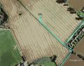
Google Earth Track - Midnight
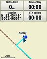
Proof
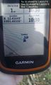
Re-proof. @52.4545,1.4655
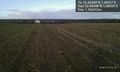
View. @52.4545,1.4655
Google Earth Track - Day time
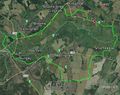
Tron Track


Achievements
Sourcerer earned the Midnight Geohash achievement
|
Sourcerer earned the Walk geohash Achievement
|
Sourcerer earned the Tron achievement
|
Expeditions and Plans
| 2016-11-27 | ||
|---|---|---|
| Providence, Rhode Island | Ghostbusters | Across Tower Hill Road from South County Commons. Easy hash. |
| Landshut, Germany | TheOneRing | on a field near Vilsbiburg. |
| Norwich, United Kingdom | Sourcerer | A field near Mettingham, Suffolk, UK, 600 metres from a retro point. |
Sourcerer's Expedition Links
2016-11-26 52 1 - 2016-11-27 52 1 - 2016-11-28 52 1 - KML file download of Sourcerer's expeditions for use with Google Earth.