Difference between revisions of "2016-11-28 52 1"
imported>Sourcerer m ([live picture] Arrived. [http://www.openstreetmap.org/?lat=52.78998792&lon=1.03717268&zoom=16&layers=B000FTF @52.7900,1.0372]) |
imported>Sourcerer m (→New expedition) |
||
| Line 17: | Line 17: | ||
== Plans == | == Plans == | ||
| − | ETA 23:30. | + | One of two spanning midnight - [[2016-11-28 52 1]] - [[2016-11-29 52 1]] - ETA 23:30. |
== Expedition == | == Expedition == | ||
| + | This was easy enough and the first frozen geohash of the year. There was no wind so the cold did not penetrate. There was space to park at the field entrance and a perimeter path and tractor tracks led to the hashpoint with a small deviation around a bomb crater pool. There was a crisp grass frost. | ||
| + | In the Google Earth image, you can see four aligned bomb craters left over from World War Two. There were many airfields in the region and most of them got bombed, not always with great accuracy. | ||
== Photos == | == Photos == | ||
<gallery caption="Photo Gallery" perrow="3"> | <gallery caption="Photo Gallery" perrow="3"> | ||
| − | |||
Image:2016-11-28_52_1_Sourcerer_1480372680575.jpg | Arrived. [http://www.openstreetmap.org/?lat=52.78998792&lon=1.03717268&zoom=16&layers=B000FTF @52.7900,1.0372] | Image:2016-11-28_52_1_Sourcerer_1480372680575.jpg | Arrived. [http://www.openstreetmap.org/?lat=52.78998792&lon=1.03717268&zoom=16&layers=B000FTF @52.7900,1.0372] | ||
| + | Image:2016-11-28_52_1_Sourcerer.jpg | Google Earth Track | ||
| + | Image:2016-11-28_52_1_Sourcerer Frozen.jpg | Frozen Geohash | ||
</gallery> | </gallery> | ||
| Line 39: | Line 42: | ||
}} | }} | ||
| − | + | ||
| − | |||
[[Category:Expeditions]] | [[Category:Expeditions]] | ||
[[Category:Expeditions with photos]] | [[Category:Expeditions with photos]] | ||
[[Category:Coordinates reached]] | [[Category:Coordinates reached]] | ||
| − | |||
Revision as of 00:53, 29 November 2016
| Mon 28 Nov 2016 in Norwich, UK: 52.7899887, 1.0371662 geohashing.info google osm bing/os kml crox |
Location
A field east of Foulsham, Norfolk, UK.
Participants
Plans
One of two spanning midnight - 2016-11-28 52 1 - 2016-11-29 52 1 - ETA 23:30.
Expedition
This was easy enough and the first frozen geohash of the year. There was no wind so the cold did not penetrate. There was space to park at the field entrance and a perimeter path and tractor tracks led to the hashpoint with a small deviation around a bomb crater pool. There was a crisp grass frost.
In the Google Earth image, you can see four aligned bomb craters left over from World War Two. There were many airfields in the region and most of them got bombed, not always with great accuracy.
Photos
- Photo Gallery
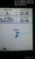
Arrived. @52.7900,1.0372
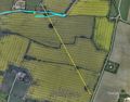
Google Earth Track
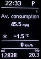
Frozen Geohash


Achievements
Expeditions and Plans
| 2016-11-28 | ||
|---|---|---|
| Norwich, United Kingdom | Sourcerer | A field east of Foulsham, Norfolk, UK. |
Sourcerer's Expedition Links
2016-11-27 52 1 - 2016-11-28 52 1 - 2016-11-29 52 1 - KML file download of Sourcerer's expeditions for use with Google Earth.