| Mon 5 Dec 2016 in Norwich, UK: 52.2814757, 1.5953862 geohashing.info google osm bing/os kml crox |
Location
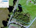
A field in Dunwich Forest near Potton Hall, Suffolk, UK.
Participants
Plans
Go during the day and plan a route for the Waveney Ramblers on the same expedition.
Expedition - Fail
The five mile walk was good apart from diversions due to forestry work. On Google, the hashpoint looked as though it was in a meadow. In real life there was a new fence and it was in impenetrable dense gorse on the wrong side. Nothing less than a chain saw would get you into that tangled mess.
Photos
- Photo Gallery
Google Earth Track
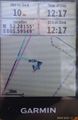
Proof
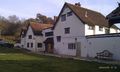
Potton Hall


Achievements
Expeditions and Plans
| 2016-12-05 | ||
|---|---|---|
| Kassel, Germany | GeorgDerReisende | The hash lay on a field at Niederkaufungen. |
| Norwich, United Kingdom | Sourcerer | A field in Dunwich Forest near Potton Hall, Suffolk, UK. |
Sourcerer's Expedition Links
2016-12-03 52 1 - 2016-12-05 52 1 - 2016-12-10 52 1 - KML file download of Sourcerer's expeditions for use with Google Earth.